by Joseph P. Farrell, Giza Death Star: Regular readers of this website, and even more so the paying members, know that I am a devotee of the works of C.S. Lewis, the famous Oxford don and Christian apologist , member of the “Inklings” with other famous (and Christian) authors, J.R.R. Tolkien, Charles Williams, and so […]
Day: August 22, 2024
Beyoncé ‘Never Scheduled’ to Perform at the DNC, Rep Says
Pop singer Beyoncé was “never scheduled” to perform on the last night of the DNC despite reports that were circulating on Thursday.
The post Beyoncé ‘Never Scheduled’ to Perform at the DNC, Rep Says appeared first on Breitbart.
Tropical Storm Hone Public Advisory
…HONE CONTINUING TO MOVE WESTWARD TO THE EAST-SOUTHEAST OF THE HAWAIIAN ISLANDS… …TROPICAL STORM WATCH ISSUED FOR THE BIG ISLAND…
As of 5:00 PM HST Thu Aug 22
the center of Hone was located near 15.8, -143.4
with movement W at 16 mph.
The minimum central pressure was 1004 mb
with maximum sustained winds of about 40 mph.
Tropical Storm Hone Forecast Advisory
Issued at 0300 UTC FRI AUG 23 2024
216 WTPA21 PHFO 230249 TCMCP1 TROPICAL STORM HONE FORECAST/ADVISORY NUMBER 3 NWS CENTRAL PACIFIC HURRICANE CENTER HONOLULU HI CP012024 0300 UTC FRI AUG 23 2024 NOTICE... LAND-BASED TROPICAL CYCLONE WATCHES AND WARNINGS ARE NO LONGER INCLUDED IN THE TROPICAL CYCLONE FORECAST/ADVISORY...(TCM). CURRENT LAND-BASED COASTAL WATCHES AND WARNINGS CAN BE FOUND IN THE MOST RECENTLY ISSUED TROPICAL CYCLONE PUBLIC ADVISORY...(TCP). TROPICAL STORM CENTER LOCATED NEAR 15.8N 143.4W AT 23/0300Z POSITION ACCURATE WITHIN 30 NM PRESENT MOVEMENT TOWARD THE WEST OR 275 DEGREES AT 14 KT ESTIMATED MINIMUM CENTRAL PRESSURE 1004 MB MAX SUSTAINED WINDS 35 KT WITH GUSTS TO 45 KT. 34 KT....... 25NE 0SE 0SW 25NW. 12 FT SEAS..125NE 25SE 0SW 200NW. WINDS AND SEAS VARY GREATLY IN EACH QUADRANT. RADII IN NAUTICAL MILES ARE THE LARGEST RADII EXPECTED ANYWHERE IN THAT QUADRANT. REPEAT...CENTER LOCATED NEAR 15.8N 143.4W AT 23/0300Z AT 23/0000Z CENTER WAS LOCATED NEAR 15.7N 142.8W FORECAST VALID 23/1200Z 16.1N 145.4W MAX WIND 40 KT...GUSTS 50 KT. 34 KT... 35NE 20SE 0SW 35NW. FORECAST VALID 24/0000Z 16.4N 147.9W MAX WIND 45 KT...GUSTS 55 KT. 34 KT... 40NE 20SE 0SW 40NW. FORECAST VALID 24/1200Z 16.8N 150.6W MAX WIND 50 KT...GUSTS 60 KT. 50 KT... 15NE 0SE 0SW 15NW. 34 KT... 60NE 30SE 20SW 50NW. FORECAST VALID 25/0000Z 17.1N 152.9W MAX WIND 55 KT...GUSTS 65 KT. 50 KT... 20NE 0SE 0SW 20NW. 34 KT... 80NE 50SE 40SW 70NW. FORECAST VALID 25/1200Z 17.3N 155.2W MAX WIND 60 KT...GUSTS 75 KT. 50 KT... 20NE 20SE 0SW 20NW. 34 KT... 80NE 50SE 40SW 80NW. FORECAST VALID 26/0000Z 17.7N 157.1W MAX WIND 60 KT...GUSTS 75 KT. 50 KT... 30NE 20SE 20SW 30NW. 34 KT... 80NE 50SE 40SW 80NW. EXTENDED OUTLOOK. NOTE...ERRORS FOR TRACK HAVE AVERAGED NEAR 150 NM ON DAY 4 AND 200 NM ON DAY 5...AND FOR INTENSITY NEAR 20 KT EACH DAY OUTLOOK VALID 27/0000Z 18.6N 159.7W MAX WIND 60 KT...GUSTS 75 KT. 50 KT... 30NE 20SE 20SW 30NW. 34 KT... 80NE 50SE 40SW 80NW. OUTLOOK VALID 28/0000Z 19.5N 162.2W MAX WIND 50 KT...GUSTS 60 KT. 50 KT... 20NE 0SE 0SW 20NW. 34 KT... 70NE 40SE 30SW 60NW. REQUEST FOR 3 HOURLY SHIP REPORTS WITHIN 300 MILES OF 15.8N 143.4W NEXT ADVISORY AT 23/0900Z $$ FORECASTER M BALLARD
Hurricane Gilma Forecast Discussion
Issued at 500 PM HST Thu Aug 22 2024
Hurricane Gilma Wind Speed Probabilities
Issued at 0300 UTC FRI AUG 23 2024
Hurricane Gilma Public Advisory
…GILMA EXPECTED TO REMAIN A MAJOR HURRICANE INTO FRIDAY BUT MORE WEAKENING LIES AHEAD…
As of 5:00 PM HST Thu Aug 22
the center of Gilma was located near 17.3, -125.5
with movement WNW at 6 mph.
The minimum central pressure was 959 mb
with maximum sustained winds of about 120 mph.
Hurricane Gilma Forecast Advisory
Issued at 0300 UTC FRI AUG 23 2024
000 WTPZ22 KNHC 230232 TCMEP2 HURRICANE GILMA FORECAST/ADVISORY NUMBER 19 NWS NATIONAL HURRICANE CENTER MIAMI FL EP072024 0300 UTC FRI AUG 23 2024 HURRICANE CENTER LOCATED NEAR 17.3N 125.5W AT 23/0300Z POSITION ACCURATE WITHIN 20 NM PRESENT MOVEMENT TOWARD THE WEST-NORTHWEST OR 295 DEGREES AT 5 KT ESTIMATED MINIMUM CENTRAL PRESSURE 959 MB EYE DIAMETER 10 NM MAX SUSTAINED WINDS 105 KT WITH GUSTS TO 130 KT. 64 KT....... 30NE 25SE 25SW 30NW. 50 KT....... 50NE 40SE 40SW 50NW. 34 KT.......100NE 90SE 80SW 100NW. 12 FT SEAS..150NE 180SE 180SW 180NW. WINDS AND SEAS VARY GREATLY IN EACH QUADRANT. RADII IN NAUTICAL MILES ARE THE LARGEST RADII EXPECTED ANYWHERE IN THAT QUADRANT. REPEAT...CENTER LOCATED NEAR 17.3N 125.5W AT 23/0300Z AT 23/0000Z CENTER WAS LOCATED NEAR 17.2N 125.2W FORECAST VALID 23/1200Z 17.6N 126.6W MAX WIND 100 KT...GUSTS 120 KT. 64 KT... 30NE 25SE 20SW 25NW. 50 KT... 50NE 40SE 40SW 50NW. 34 KT...100NE 80SE 80SW 100NW. FORECAST VALID 24/0000Z 18.0N 128.1W MAX WIND 95 KT...GUSTS 115 KT. 64 KT... 30NE 25SE 20SW 25NW. 50 KT... 50NE 40SE 30SW 40NW. 34 KT... 90NE 70SE 70SW 90NW. FORECAST VALID 24/1200Z 18.4N 129.8W MAX WIND 90 KT...GUSTS 110 KT. 64 KT... 30NE 25SE 20SW 25NW. 50 KT... 50NE 40SE 30SW 40NW. 34 KT... 90NE 60SE 60SW 90NW. FORECAST VALID 25/0000Z 18.8N 131.5W MAX WIND 85 KT...GUSTS 105 KT. 64 KT... 25NE 20SE 20SW 25NW. 50 KT... 40NE 30SE 30SW 40NW. 34 KT... 90NE 60SE 60SW 90NW. FORECAST VALID 25/1200Z 19.0N 133.3W MAX WIND 80 KT...GUSTS 100 KT. 50 KT... 40NE 30SE 30SW 40NW. 34 KT... 90NE 60SE 60SW 90NW. FORECAST VALID 26/0000Z 19.2N 135.3W MAX WIND 70 KT...GUSTS 85 KT. 50 KT... 40NE 30SE 20SW 40NW. 34 KT... 90NE 60SE 50SW 80NW. EXTENDED OUTLOOK. NOTE...ERRORS FOR TRACK HAVE AVERAGED NEAR 100 NM ON DAY 4 AND 125 NM ON DAY 5...AND FOR INTENSITY NEAR 15 KT EACH DAY OUTLOOK VALID 27/0000Z 19.8N 139.8W MAX WIND 55 KT...GUSTS 65 KT. 50 KT... 30NE 0SE 0SW 30NW. 34 KT... 70NE 40SE 30SW 70NW. OUTLOOK VALID 28/0000Z 20.5N 145.3W...POST-TROPICAL MAX WIND 35 KT...GUSTS 45 KT. 34 KT... 50NE 0SE 0SW 50NW. REQUEST FOR 3 HOURLY SHIP REPORTS WITHIN 300 MILES OF 17.3N 125.5W NEXT ADVISORY AT 23/0900Z $$ FORECASTER BERG
This Is The Chart That Keeps Japanese Policymakers Up At Night
Japan has a demographic crisis that started in 2017 and picked up steam in 2020 and will accelerate from there into at least 2050… as a high life expectancy and a low birth rate has created an unprecedented aging population.
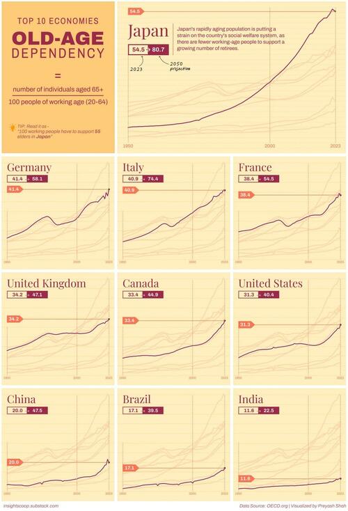
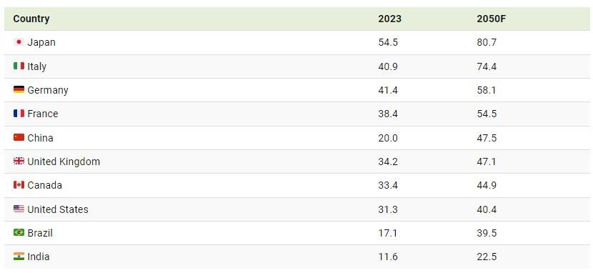
As a simple and effective measure of that ‘crisis’, we look at the old-age dependency ratio measures the number of people over the retirement age of 65 for every 100 working-age people.
The higher dependency ratio means fewer workers are supporting a growing number of retirees, which strains social security systems, healthcare, and pension funds. This situation could lead to economic stagnation or decline unless addressed through policy changes like increasing immigration or boosting birth rates.
In charts by creator Preyash Shad, Visual Capitalist looks at old-age dependency ratios of the top 10 economies based on data from the Organisation for Economic Co-operation and Development (OECD).
Japan in Trouble
Japan has had a rapidly rising old-age dependency ratio for several decades and has the highest ratio currently at 54.5.
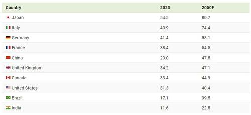
Meanwhile, Germany is the runner-up in the top 10 economies with a distant second-place dependency ratio of 41.4.
At the same time, the United States maintains a relatively low old-age dependency, with a ratio of 31.3, which places it seventh among the top 10 economies.
India, now the world’s most populous country, has the lowest ratio of 11.6, in large part because it also has the youngest population.
Projections for 2050
By 2050, Japan will maintain the highest old-age dependency ratio of the group, moving from 54.5 to a staggering 80.7.
In an effort to head-off such a high ratio, Japan is has put policies in pace to attract young immigrants and migrant workers.
However, despite government incentives, cultural shifts towards later marriages, fewer children, and more women entering the workforce have not significantly reversed the trend in Japan (or many other nations).
Italy, which is facing similar demographic pressures, will move from distant third to a close second, moving from a ratio of 40.9 to 74.4.
China, because of the results of the one-child policy and low immigration, could surpass the U.S. by 2050 with a ratio of 47.5.
Tyler Durden
Thu, 08/22/2024 – 20:30
*** DNC Livewire Night 4 *** It’s Kamala’s Turn: Harris to Speak to Dysfunctional Convention
Vice President Kamala Harris will complete her coup against President Joe Biden on Thursday night when she addresses the Democratic National Convention (DNC), the dysfunctional gathering of Democrats in Chicago, Illinois.
The post *** DNC Livewire Night 4 *** It’s Kamala’s Turn: Harris to Speak to Dysfunctional Convention appeared first on Breitbart.