


COVID-19: The Preventable Pandemic | ZeroHedge
Authored by Jeff M. Smith via RealClearWorld,
When the Heritage Foundation released its comprehensive report on the origins of the Covid-19 pandemic, headlines tended to focus on the cost to the U.S. That’s not surprising: At an eye-popping $18 trillion, it’s almost 10 times the projected 2024 budget deficit.
Arguably, however, the Commission’s most infuriating conclusion was this: The global pandemic was “totally preventable,” in the words of Commissioner Dr. Robert Redfield, an experienced virologist who headed the CDC during the outbreak.
Had the Chinese government been more transparent and cooperative at the outset of the pandemic, millions of lives and trillions of dollars could have been spared. The pandemic’s “proximal origin,” the Commission found, was the Chinese government’s “aggressive opposition to honesty, transparency, and accountability” along with its “systemic cover up.”
The Cover-Up
The Commission—a blue-ribbon team of experts led by former Director of National Intelligence John Ratcliffe and supported by data scientists, economists, and lawyers—concluded that the SARS-CoV-2 virus began circulating months before Beijing warned the world, likely in August-September 2019. The Chinese government then not only withheld key details, it engaged in an elaborate and deadly coverup.
Dr. Jamie Metzl—one of the Commission’s Democrats who served at the National Security Council, U.S. Senate, and State Department—condemned Beijing for having “destroyed samples, hidden records, imprisoned Chinese citizen journalists, gagged Chinese scientists, blocked any meaningful international investigations, and cynically sandbagged the World Health Organization.”
Ratcliffe described China’s behavior during this period as “frankly inexcusable.”
Added Metzl: “There can be, in our view, little doubt that China’s government is primarily responsible for the COVID-19 pandemic. But for the unique pathologies of the Chinese state, there very likely would have been no pandemic at all.”
The Cost
Worldwide, the COVID-19 pandemic is considered one of the seven deadliest plagues in human history, with excess deaths topping 28 million, according to some estimates. The World Bank has characterized the economic upheaval caused by the pandemic as “the largest global economic crisis in more than a century,” with low-income countries hit the hardest.
The Commission’s assessment that the pandemic cost the U.S. alone $18 trillion includes $8.6 trillion in “excess deaths,” $1.8 trillion in income lost, $6 trillion in chronic conditions like “long COVID,” $1.1 trillion in mental health costs, and $400 million in education losses.
The Origin
While the origin of the pandemic wasn’t the focus of the Commission, notably all nine Commissioners concluded, without dissent, that the pandemic “very likely stemmed from a research-related incident in Wuhan.”
Indeed, evidence continues to emerge further strengthening the “lab leak” theory and casting greater doubt on the “natural spillover” theory. The Wuhan Institute of Virology (WIV) was at the time conducting dangerous gain of function experiments to make coronaviruses more transmissible to humans, and it was doing so in alarmingly unsafe conditions.
The WIV experienced an unspecified “incident” in 2019, when several lab workers fell sick, the Chinese military abruptly assumed control of the lab, the lab mysteriously deleted its online database of over 10,000 bat virus samples at 2:00am, and ordered an expensive new air incinerator. A Chinese military scientist then produced a vaccine with logic-defying speed before suddenly going missing and being scrubbed from government records.
In recent months, new details have emerged about a 2018 grant proposal that sought funding to manipulate coronaviruses at the WIV in very specific ways—ways that exactly match the highly unusual features of the SARS-CoV-2 virus that have never been seen in nature.
At the event unveiling the Heritage report, Dr. Redfield contended SARS-CoV-2 shows “clear signs of engineering” and its origin “had nothing to do with” a natural spillover event at a Wuhan animal market. The full Commission report concludes that despite four years of extensive hypothesis testing, today “there is no evidentiary basis” for the theory of natural spillover. The handful of early pandemic academic papers advancing the natural spillover theory have since been hollowed out by fatal challenges to their underlying methods and conclusions.
Rather than a viral leap from animal to humans, Dr. Redfield contended that the pandemic was “a direct consequence of scientific arrogance, with the scientists that were intentionally teaching this virus how to infect humans never recognizing something would ever go wrong. And, in fact, unfortunately this virus did escape.”
Preventing Another Pandemic
To avoid a future pandemic and hold the Chinese government accountable, the Commission report concluded with several practical recommendations for the U.S. government:
-
Establish a bipartisan national COVID commission to conduct “a review of China’s negligence and cover-up as well as an evaluation of domestic policies that were implemented” in response to the pandemic;
-
Create a bipartisan reparations or compensation task force to cover claims against the Chinese government;
-
Facilitate the filing of civil claims against China to allow civilians harmed by COVID to receive compensation by amending the Foreign Sovereign Immunities Act;
-
Decouple U.S. government and commercial supply chains from Chinese state-backed companies;
-
Audit all U.S. government funding for biomedical research and related research activities in China;
-
Impose economic sanctions on Chinese officials and entities who were complicit in or supported the “distortion and concealment” of information related to the COVID pandemic.
The COVID-19 pandemic was almost certainly the deadliest and costliest event of the 21st century. Beijing’s ability to escape virtually any accountability—and the global media’s relative disinterest in the pandemic’s origins, cost, and China’s culpability—are equal parts confounding and infuriating.
“China’s response to SARS1 20 years ago was abysmal,” Dr. Metzl argued at the Heritage event. “China’s response to SARS2, 20 years later despite all these international processes, was even worse. And the reason…is there was no accountability for all the obfuscation in the first case. With 28 million people dead as a result of COVID-19 and tens of trillions of dollars in damages it simply unacceptable, and frankly unimaginable, that every stone should not be overturned examining what went wrong.”
Loading…
Originally Posted at; https://www.zerohedge.com//
Stay Updated with news.freeptomaineradio.com’s Daily Newsletter
Stay informed! Subscribe to our daily newsletter to receive updates on our latest blog posts directly in your inbox. Don’t let important information get buried by big tech.
Current subscribers:
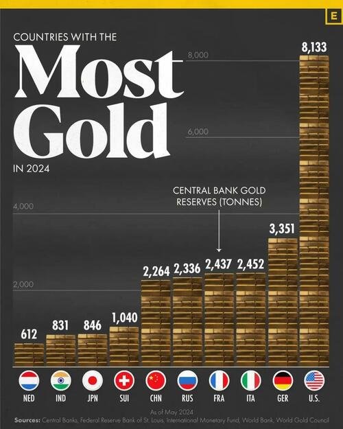
The Top 10 Countries By Gold Reserves In 2024 (& Who’s Adding Most)
Central banks hold gold reserves due to their safety, liquidity, and return characteristics.
They are significant owners of gold, accounting for approximately a fifth of all the gold mined throughout history.
The country with the most gold is the United States, with 8,133 tonnes, which has a value of $579 billion.
The top ten countries in total gold reserves (tonnes) as of May 2024.
These figures come from the World Gold Council.
Amid escalating geopolitical tensions, increased sanctions, and discussions around de-dollarization, interest in gold purchases is rising.
But which countries are leading the charge in increasing their gold reserves?
This graphic, via Visual Capitalist’s Bruno Venditti, ranks the top 10 countries by the change in gold reserves over the past decade (2013-2023).

The figures, measured in tonnes, were compiled by the World Gold Council.
Russia and China Lead in Gold Purchases
Central banks, particularly those of Russia and China, have bought gold at the fastest pace as countries seek to diversify their reserves away from the dollar.

Russia’s reserves jumped from 1,035 tonnes in 2013 to 2,333 in 2023. China’s reserves rose from 1,054 tonnes to 2,235 in 2023.
In third place in our ranking of central bank gold additions, Türkiye increased its reserves from 116 tonnes in 2013 to 540 tonnes in 2023.
Loading…
Originally Posted at; https://www.zerohedge.com//
Stay Updated with news.freeptomaineradio.com’s Daily Newsletter
Stay informed! Subscribe to our daily newsletter to receive updates on our latest blog posts directly in your inbox. Don’t let important information get buried by big tech.
Current subscribers:
Hurricane Gilma Wind Speed Probabilities
000
FOPZ12 KNHC 240232
PWSEP2

HURRICANE GILMA WIND SPEED PROBABILITIES NUMBER  23
NWS NATIONAL HURRICANE CENTER MIAMI FL       EP072024
0300 UTC SAT AUG 24 2024

AT 0300Z THE CENTER OF HURRICANE GILMA WAS LOCATED NEAR LATITUDE
17.5 NORTH...LONGITUDE 128.4 WEST WITH MAXIMUM SUSTAINED WINDS NEAR
90 KTS...105 MPH...165 KM/H.

Z INDICATES COORDINATED UNIVERSAL TIME (GREENWICH)
   PACIFIC  DAYLIGHT TIME (PDT)...SUBTRACT 7 HOURS FROM Z TIME
   HAWAIIAN STANDARD TIME (HST)...SUBTRACT 10 HOURS FROM Z TIME

WIND SPEED PROBABILITY TABLE FOR SPECIFIC LOCATIONS

CHANCES OF SUSTAINED (1-MINUTE AVERAGE) WIND SPEEDS OF AT LEAST
   ...34 KT (39 MPH... 63 KM/H)...
   ...50 KT (58 MPH... 93 KM/H)...
   ...64 KT (74 MPH...119 KM/H)...
FOR LOCATIONS AND TIME PERIODS DURING THE NEXT 5 DAYS

PROBABILITIES FOR LOCATIONS ARE GIVEN AS OP(CP) WHERE
    OP  IS THE PROBABILITY OF THE EVENT BEGINNING DURING
        AN INDIVIDUAL TIME PERIOD (ONSET PROBABILITY)
   (CP) IS THE PROBABILITY OF THE EVENT OCCURRING BETWEEN
        00Z SAT AND THE FORECAST HOUR (CUMULATIVE PROBABILITY)

PROBABILITIES ARE GIVEN IN PERCENT
X INDICATES PROBABILITIES LESS THAN 1 PERCENT
PROBABILITIES FOR 34 KT AND 50 KT ARE SHOWN AT A GIVEN LOCATION WHEN
THE 5-DAY CUMULATIVE PROBABILITY IS AT LEAST 3 PERCENT.
PROBABILITIES FOR 34...50...64 KT SHOWN WHEN THE 5-DAY
64-KT CUMULATIVE PROBABILITY IS AT LEAST 1 PERCENT.


  - - - - WIND SPEED PROBABILITIES FOR SELECTED LOCATIONS - - - -

               FROM    FROM    FROM    FROM    FROM    FROM    FROM
  TIME       00Z SAT 12Z SAT 00Z SUN 12Z SUN 00Z MON 00Z TUE 00Z WED
PERIODS         TO      TO      TO      TO      TO      TO      TO
             12Z SAT 00Z SUN 12Z SUN 00Z MON 00Z TUE 00Z WED 00Z THU

FORECAST HOUR    (12)   (24)    (36)    (48)    (72)    (96)   (120)
- - - - - - - - - - - - - - - - - - - - - - - - - - - - - - - - - -
LOCATION       KT

15N 130W       34  3   3( 6)   2( 8)   1( 9)   X( 9)   X( 9)   X( 9)

20N 130W       34  9  12(21)   2(23)   1(24)   X(24)   X(24)   X(24)

15N 135W       34  X   2( 2)   3( 5)   3( 8)   3(11)   X(11)   X(11)

20N 135W       34  X   4( 4)  21(25)  27(52)   5(57)   X(57)   X(57)
20N 135W       50  X   X( X)   2( 2)  10(12)   2(14)   X(14)   X(14)
20N 135W       64  X   X( X)   X( X)   4( 4)   1( 5)   X( 5)   X( 5)

15N 140W       34  X   X( X)   X( X)   X( X)   4( 4)   1( 5)   X( 5)

20N 140W       34  X   X( X)   X( X)   3( 3)  24(27)  12(39)   X(39)
20N 140W       50  X   X( X)   X( X)   X( X)   6( 6)   3( 9)   X( 9)
20N 140W       64  X   X( X)   X( X)   X( X)   1( 1)   1( 2)   X( 2)

20N 145W       34  X   X( X)   X( X)   X( X)   X( X)  12(12)   6(18)
20N 145W       50  X   X( X)   X( X)   X( X)   X( X)   2( 2)   1( 3)

20N 150W       34  X   X( X)   X( X)   X( X)   X( X)   X( X)   4( 4)

20N 151W       34  X   X( X)   X( X)   X( X)   X( X)   X( X)   3( 3)

$$
FORECASTER KELLY
Originally Posted at:
NATIONAL HURRICANE CENTER and CENTRAL PACIFIC HURRICANE CENTER
At The NATIONAL OCEANIC AND ATMOSPHERIC ADMINISTRATION
Stay Updated with news.freeptomaineradio.com’s Daily Newsletter
Stay informed! Subscribe to our daily newsletter to receive updates on our latest blog posts directly in your inbox. Don’t let important information get buried by big tech.
Current subscribers:
Hurricane Gilma Forecast Discussion
000
WTPZ42 KNHC 240232
TCDEP2

Hurricane Gilma Discussion Number  23
NWS National Hurricane Center Miami FL       EP072024
500 PM HST Fri Aug 23 2024

Gilma's satellite depiction has changed very little since earlier
today, as the eye has become filled and now the center resides
beneath the central dense overcast (CDO) on both visible and
infrared imagery. Deep convection continues to burst within the
inner core with cold cloud tops to near -80 C, with generally good
outflow in all directions. The subjective and objective intensity
estimates have remained steady with this advisory as well, with a
current intensity (CI) of 5.0 from both SAB and TAFB. Given the
steady state of satellite imagery and the intensity estimates, the
initial intensity is held at 90 kt for this advisory.

The hurricane is continuing to move generally westward at an initial
motion of 280/8 kt.  A ridge has started to build to the north of
Gilma, which will keep the system on a generally westward track,
with a gradual increase in forward motion. The track model guidance
is in fairly good agreement with the general direction the system
moves, however how fast that increase in forward speed occurs leads
to some along-track differences in the model suite, particularly at
the end of the forecast period. The official NHC track forecast is
near the previous forecast, just nudged slightly southward and
faster, near the consensus aids.

Gilma is in a low wind shear environment, however the system is
about to run into cooler sea surface temperatures with very little
ocean heat content beyond the next 24 h or so. As the system moves
over cooler waters it will also encounter a much drier and stable
airmass. These changes in oceanic and atmospheric conditions will
lead to gradual weakening over the next 24 hours followed by an
increasing rate of weakening through the end of the period. Towards
the end of the forecast period, conditions continue to become
unfavorable with upper-level westerly wind shear increasing, and
the GFS depicts the system struggling to produce convection,
becoming a remnant low at 120 h. The official NHC intensity forecast
is similar to the previous advisory, near the simple consensus
intensity aids.


FORECAST POSITIONS AND MAX WINDS

INIT  24/0300Z 17.5N 128.4W   90 KT 105 MPH
 12H  24/1200Z 17.7N 129.7W   85 KT 100 MPH
 24H  25/0000Z 18.0N 131.5W   80 KT  90 MPH
 36H  25/1200Z 18.2N 133.4W   75 KT  85 MPH
 48H  26/0000Z 18.4N 135.1W   70 KT  80 MPH
 60H  26/1200Z 18.6N 137.0W   60 KT  70 MPH
 72H  27/0000Z 18.9N 139.0W   50 KT  60 MPH
 96H  28/0000Z 19.4N 143.7W   40 KT  45 MPH
120H  29/0000Z 20.3N 148.7W   30 KT  35 MPH...POST-TROP/REMNT LOW

$$
Forecaster Kelly
Originally Posted at:
NATIONAL HURRICANE CENTER and CENTRAL PACIFIC HURRICANE CENTER
At The NATIONAL OCEANIC AND ATMOSPHERIC ADMINISTRATION
Stay Updated with news.freeptomaineradio.com’s Daily Newsletter
Stay informed! Subscribe to our daily newsletter to receive updates on our latest blog posts directly in your inbox. Don’t let important information get buried by big tech.
Current subscribers:
Tropical Storm Hone Forecast Advisory
716
WTPA21 PHFO 240232
TCMCP1

TROPICAL STORM HONE FORECAST/ADVISORY NUMBER   7
NWS CENTRAL PACIFIC HURRICANE CENTER HONOLULU HI   CP012024
0300 UTC SAT AUG 24 2024

NOTICE... LAND-BASED TROPICAL CYCLONE WATCHES AND WARNINGS ARE NO
LONGER INCLUDED IN THE TROPICAL CYCLONE FORECAST/ADVISORY...(TCM).
CURRENT LAND-BASED COASTAL WATCHES AND WARNINGS CAN BE FOUND IN THE
MOST RECENTLY ISSUED TROPICAL CYCLONE PUBLIC ADVISORY...(TCP).

TROPICAL STORM CENTER LOCATED NEAR 16.9N 149.3W AT 24/0300Z
POSITION ACCURATE WITHIN  20 NM

PRESENT MOVEMENT TOWARD THE WEST OR 280 DEGREES AT  14 KT

ESTIMATED MINIMUM CENTRAL PRESSURE 1000 MB
MAX SUSTAINED WINDS  45 KT WITH GUSTS TO  55 KT.
34 KT.......100NE  40SE  50SW  90NW.
12 FT SEAS..230NE  60SE  60SW 230NW.
WINDS AND SEAS VARY GREATLY IN EACH QUADRANT.  RADII IN NAUTICAL
MILES ARE THE LARGEST RADII EXPECTED ANYWHERE IN THAT QUADRANT.

REPEAT...CENTER LOCATED NEAR 16.9N 149.3W AT 24/0300Z
AT 24/0000Z CENTER WAS LOCATED NEAR 16.8N 148.6W

FORECAST VALID 24/1200Z 17.3N 151.4W
MAX WIND  50 KT...GUSTS  60 KT.
50 KT... 10NE   0SE   0SW   0NW.
34 KT... 90NE  40SE  40SW  80NW.

FORECAST VALID 25/0000Z 17.6N 154.1W
MAX WIND  55 KT...GUSTS  65 KT.
50 KT... 20NE   0SE   0SW  10NW.
34 KT... 90NE  40SE  40SW  70NW.

FORECAST VALID 25/1200Z 17.9N 156.4W
MAX WIND  60 KT...GUSTS  75 KT.
50 KT... 20NE   0SE   0SW  20NW.
34 KT... 80NE  60SE  40SW  80NW.

FORECAST VALID 26/0000Z 18.2N 158.5W
MAX WIND  65 KT...GUSTS  80 KT.
64 KT... 20NE   0SE   0SW  10NW.
50 KT... 30NE  10SE  10SW  20NW.
34 KT... 90NE  60SE  40SW  90NW.

FORECAST VALID 26/1200Z 18.6N 160.6W
MAX WIND  60 KT...GUSTS  75 KT.
50 KT... 30NE  10SE  10SW  20NW.
34 KT... 90NE  60SE  40SW  90NW.

FORECAST VALID 27/0000Z 19.0N 162.5W
MAX WIND  55 KT...GUSTS  65 KT.
50 KT... 20NE   0SE   0SW  10NW.
34 KT... 80NE  50SE  40SW  70NW.

EXTENDED OUTLOOK. NOTE...ERRORS FOR TRACK HAVE AVERAGED NEAR 150 NM
ON DAY 4 AND 200 NM ON DAY 5...AND FOR INTENSITY NEAR 20 KT EACH DAY

OUTLOOK VALID 28/0000Z 19.7N 165.7W
MAX WIND  50 KT...GUSTS  60 KT.
50 KT... 10NE   0SE   0SW   0NW.
34 KT... 70NE  50SE  40SW  60NW.

OUTLOOK VALID 29/0000Z 20.4N 168.8W
MAX WIND  35 KT...GUSTS  45 KT.
34 KT... 40NE  10SE  10SW  20NW.

REQUEST FOR 3 HOURLY SHIP REPORTS WITHIN 300 MILES OF 16.9N 149.3W

INTERMEDIATE PUBLIC ADVISORY...WTNT31 PHFO/HFOTCPCP1...AT 24/0600Z

NEXT ADVISORY AT 24/0900Z

$$
FORECASTER WROE
Originally Posted at:
NATIONAL HURRICANE CENTER and CENTRAL PACIFIC HURRICANE CENTER
At The NATIONAL OCEANIC AND ATMOSPHERIC ADMINISTRATION
Stay Updated with news.freeptomaineradio.com’s Daily Newsletter
Stay informed! Subscribe to our daily newsletter to receive updates on our latest blog posts directly in your inbox. Don’t let important information get buried by big tech.
Current subscribers:
Hurricane Gilma Forecast Advisory
000
WTPZ22 KNHC 240231
TCMEP2

HURRICANE GILMA FORECAST/ADVISORY NUMBER  23
NWS NATIONAL HURRICANE CENTER MIAMI FL       EP072024
0300 UTC SAT AUG 24 2024

HURRICANE CENTER LOCATED NEAR 17.5N 128.4W AT 24/0300Z
POSITION ACCURATE WITHIN  20 NM

PRESENT MOVEMENT TOWARD THE WEST OR 280 DEGREES AT   8 KT

ESTIMATED MINIMUM CENTRAL PRESSURE  970 MB
MAX SUSTAINED WINDS  90 KT WITH GUSTS TO 110 KT.
64 KT....... 30NE  25SE  25SW  30NW.
50 KT....... 50NE  40SE  40SW  50NW.
34 KT.......100NE  90SE  80SW 100NW.
12 FT SEAS..180NE 150SE 180SW 150NW.
WINDS AND SEAS VARY GREATLY IN EACH QUADRANT.  RADII IN NAUTICAL
MILES ARE THE LARGEST RADII EXPECTED ANYWHERE IN THAT QUADRANT.

REPEAT...CENTER LOCATED NEAR 17.5N 128.4W AT 24/0300Z
AT 24/0000Z CENTER WAS LOCATED NEAR 17.4N 128.0W

FORECAST VALID 24/1200Z 17.7N 129.7W
MAX WIND  85 KT...GUSTS 105 KT.
64 KT... 25NE  20SE  20SW  25NW.
50 KT... 50NE  40SE  40SW  50NW.
34 KT... 90NE  80SE  80SW  90NW.

FORECAST VALID 25/0000Z 18.0N 131.5W
MAX WIND  80 KT...GUSTS 100 KT.
64 KT... 25NE  20SE  20SW  25NW.
50 KT... 40NE  30SE  30SW  40NW.
34 KT... 90NE  70SE  70SW  90NW.

FORECAST VALID 25/1200Z 18.2N 133.4W
MAX WIND  75 KT...GUSTS  90 KT.
64 KT... 20NE  15SE  15SW  20NW.
50 KT... 40NE  30SE  30SW  40NW.
34 KT... 90NE  60SE  60SW  90NW.

FORECAST VALID 26/0000Z 18.4N 135.1W
MAX WIND  70 KT...GUSTS  85 KT.
64 KT... 20NE  10SE  10SW  20NW.
50 KT... 40NE  30SE  30SW  40NW.
34 KT... 80NE  50SE  50SW  80NW.

FORECAST VALID 26/1200Z 18.6N 137.0W
MAX WIND  60 KT...GUSTS  75 KT.
50 KT... 30NE  20SE  20SW  30NW.
34 KT... 80NE  50SE  40SW  70NW.

FORECAST VALID 27/0000Z 18.9N 139.0W
MAX WIND  50 KT...GUSTS  60 KT.
50 KT... 30NE  20SE  20SW  30NW.
34 KT... 70NE  40SE  40SW  70NW.

EXTENDED OUTLOOK. NOTE...ERRORS FOR TRACK HAVE AVERAGED NEAR 100 NM
ON DAY 4 AND 125 NM ON DAY 5...AND FOR INTENSITY NEAR 15 KT EACH DAY

OUTLOOK VALID 28/0000Z 19.4N 143.7W
MAX WIND  40 KT...GUSTS  50 KT.
34 KT... 60NE  30SE  30SW  60NW.

OUTLOOK VALID 29/0000Z 20.3N 148.7W...POST-TROP/REMNT LOW
MAX WIND  30 KT...GUSTS  40 KT.

REQUEST FOR 3 HOURLY SHIP REPORTS WITHIN 300 MILES OF 17.5N 128.4W

NEXT ADVISORY AT 24/0900Z

$$
FORECASTER KELLY
Originally Posted at:
NATIONAL HURRICANE CENTER and CENTRAL PACIFIC HURRICANE CENTER
At The NATIONAL OCEANIC AND ATMOSPHERIC ADMINISTRATION
Stay Updated with news.freeptomaineradio.com’s Daily Newsletter
Stay informed! Subscribe to our daily newsletter to receive updates on our latest blog posts directly in your inbox. Don’t let important information get buried by big tech.
Current subscribers:
Tropical Storm Hone Public Advisory
000
WTPA31 PHFO 240231
TCPCP1

BULLETIN
Tropical Storm Hone Advisory Number   7
NWS Central Pacific Hurricane Center Honolulu HI   CP012024
500 PM HST Fri Aug 23 2024

...HONE CONTINUES WESTWARD TOWARD THE HAWAIIAN ISLANDS...
...TROPICAL STORM WARNING ISSUED FOR THE BIG ISLAND OF HAWAII...


SUMMARY OF 500 PM HST...0300 UTC...INFORMATION
----------------------------------------------
LOCATION...16.9N 149.3W
ABOUT 425 MI...685 KM ESE OF HILO HAWAII
ABOUT 640 MI...1025 KM ESE OF HONOLULU HAWAII
MAXIMUM SUSTAINED WINDS...50 MPH...85 KM/H
PRESENT MOVEMENT...W OR 280 DEGREES AT 16 MPH...26 KM/H
MINIMUM CENTRAL PRESSURE...1000 MB...29.53 INCHES


WATCHES AND WARNINGS
--------------------
CHANGES WITH THIS ADVISORY:

A Tropical Storm Warning has been issued for Hawaii County.

SUMMARY OF WATCHES AND WARNINGS IN EFFECT:

A Tropical Storm Warning is in effect for...
* Hawaii County

A Tropical Storm Warning means that tropical storm conditions are
expected somewhere within the warning area within 36 hours.

Interests elsewhere in Hawaii should monitor the progress of Hone.

For storm information specific to your area, please monitor
products issued by the National Weather Service office in
Honolulu Hawaii.


DISCUSSION AND OUTLOOK
----------------------
At 500 PM HST (0300 UTC), the center of Tropical Storm Hone was
located near latitude 16.9 North, longitude 149.3 West. Hone is
moving toward the west near 16 mph (26 km/h). This motion toward the
west is expected to continue over the next several days as the
forward speed gradually slows. On the forecast track, the center of
Hone is expected to pass near or south of the Big Island Saturday
night into early Sunday.

Maximum sustained winds are near 50 mph (85 km/h) with higher gusts.
Strengthening is forecast during the next 48 hours, and may become
a hurricane by Sunday, followed by weakening late Sunday and beyond.

Tropical-storm-force winds extend outward up to 115 miles (185 km)
from the center.

The estimated minimum central pressure is 1000 mb (29.53 inches).


HAZARDS AFFECTING LAND
----------------------
Key messages for Tropical Storm Hone can be found in the
Tropical Cyclone Discussion under AWIPS header TCDCP1 and WMO
header WTPA41 PHFO, and on the web at
hurricanes.gov/text/HFOTCDCP1.shtml.

WIND: Tropical storm conditions are expected in the warning area as
early as Saturday afternoon and continuing into Sunday. Winds are
expected to be strongest where they blow downslope from higher
terrain, over headlands, and through passes.

RAINFALL: Hone is expected to produce storm total rainfall of 5 to
10 inches over mainly windward and southeast facing slopes of the
Big Island, with locally higher amounts possible. Rainfall totals
of 2 to 4 inches will be possible over portions of the smaller
islands, mainly windward.

SURF: Swells generated by Tropical Storm Hone will move across
waters around the eastern end of the Hawaiian Islands on Saturday,
mainly near the Big Island of Hawaii. The large swells will spread
across the other portions of the island chain Saturday night and
Sunday, producing life-threatening surf and rip currents.


NEXT ADVISORY
-------------
Next intermediate advisory at 800 PM HST.
Next complete advisory at 1100 PM HST.

$$
Forecaster Wroe
Originally Posted at:
NATIONAL HURRICANE CENTER and CENTRAL PACIFIC HURRICANE CENTER
At The NATIONAL OCEANIC AND ATMOSPHERIC ADMINISTRATION
Stay Updated with news.freeptomaineradio.com’s Daily Newsletter
Stay informed! Subscribe to our daily newsletter to receive updates on our latest blog posts directly in your inbox. Don’t let important information get buried by big tech.
Current subscribers:
Hurricane Gilma Public Advisory
000
WTPZ32 KNHC 240231
TCPEP2

BULLETIN
Hurricane Gilma Advisory Number  23
NWS National Hurricane Center Miami FL       EP072024
500 PM HST Fri Aug 23 2024

...GILMA CONTINUES MOVING WESTWARD...


SUMMARY OF 500 PM HST...0300 UTC...INFORMATION
----------------------------------------------
LOCATION...17.5N 128.4W
ABOUT 1255 MI...2020 KM WSW OF THE SOUTHERN TIP OF BAJA CALIFORNIA
ABOUT 1750 MI...2820 KM E OF HILO HAWAII
MAXIMUM SUSTAINED WINDS...105 MPH...165 KM/H
PRESENT MOVEMENT...W OR 280 DEGREES AT 9 MPH...15 KM/H
MINIMUM CENTRAL PRESSURE...970 MB...28.65 INCHES


WATCHES AND WARNINGS
--------------------
There are no coastal watches or warnings in effect.


DISCUSSION AND OUTLOOK
----------------------
At 500 PM HST (0300 UTC), the center of Hurricane Gilma was located
near latitude 17.5 North, longitude 128.4 West. Gilma is moving
toward the west near 9 mph (15 km/h). A generally westward motion
with an increase in forward speed is expected during the next
couple of days.

Maximum sustained winds are near 105 mph (165 km/h) with higher
gusts. Weakening is forecast during the next several days, but Gilma
is expected to remain a hurricane through the weekend.

Hurricane-force winds extend outward up to 35 miles (55 km) from the
center and tropical-storm-force winds extend outward up to 115 miles
(185 km).

The estimated minimum central pressure is 970 mb (28.65 inches).


HAZARDS AFFECTING LAND
----------------------
None


NEXT ADVISORY
-------------
Next complete advisory at 1100 PM HST.

$$
Forecaster Kelly
Originally Posted at:
NATIONAL HURRICANE CENTER and CENTRAL PACIFIC HURRICANE CENTER At The NATIONAL OCEANIC AND ATMOSPHERIC ADMINISTRATION
Stay Updated with news.freeptomaineradio.com’s Daily Newsletter
Stay informed! Subscribe to our daily newsletter to receive updates on our latest blog posts directly in your inbox. Don’t let important information get buried by big tech.
Current subscribers:
Trump Steals Kamala’s ‘Joy,’ Obama’s ‘Hope’: Harris Must Be Defeated
Donald Trump is riding high after Democrats’ failure to utilize the Democratic National Convention (DNC) to springboard Vice President Kamala Harris’s struggling campaign.
The emboldened Republican nominee even stole President Barack Obama and Vice President Kamala Harris’s trademark one-word campaign slogans in laying out his American agenda and calling to arms the crowd to vote for him in November.
“Everyone will prosper, every family will thrive, and every day will be filled with joy and opportunity and hope, but for that to happen, we must defeat Kamala Harris,” Trump told the crowd near the end of his remarks.
“We must stop her country-destroying liberal agenda once and for all,” he added.
Obama’s historic use of “Hope,” indisputable charm, and call to become the first black president elevated him to the White House over a lackluster candidate in John McCain.
Yet Harris seems content to use her “Joy” as the theme of a vibe-focused campaign that, so far, has lacked any significant substance or discussion of the issues.
The celebrity-powered DNC had its moments but never recreated the enthusiasm of Obama’s two conventions — a sentiment seemingly fueling Trump’s elevated mood.
Former President Trump seemed noticeably cheerful during events on Friday, charming crowds with his characteristic humor while hammering Democrats’ agenda.
The Arizona rally focused on border security, with Trump blasting “border czar” Kamala Harris for failing to stem the escalating tide of migrants flooding illegally into the nation.
“You’ve been the worst vice president in the history of our country. You’re fired! You’re fired! Get out. Get out! Get out, Kamala,’” Trump said as the crowd erupted.
Surprise guest Robert F. Kennedy Jr.’s appearance provided an unforgettable and historic moment. Kennedy endorsed Trump earlier in the afternoon, and his appearance on stage launched the crowd into a frenzy with chants of “Bobby!”
Trump’s rally attracted 16,200 attendees, according to event organizer Charlie Kirk. Kirk’s Turning Point Action cohosted the rally.
Hey, Kamala. Unlike you, we can actually fill up an arena. You had to cover the top row because you couldn’t fill it. We checked with the venue, and they say your rally got 10,200 people. We just got 16,200 for ours. Same venue, with LESS notice.
And we didn’t have to pay to bus… https://t.co/PspIT47D8a pic.twitter.com/GNsldblssf
— Charlie Kirk (@charliekirk11) August 24, 2024
“Hey, Kamala. Unlike you, we can actually fill up an arena.” Kirk posted on X. “You had to cover the top row because you couldn’t fill it. We checked with the venue, and they say your rally got 10,200 people. We just got 16,200 for ours. Same venue, with LESS notice. And we didn’t have to pay to bus people in!”
Harris’s campaign had goaded Trump — seemingly too soon — for attendance at a prior Harris rally in the same arena on August 9.
Bradley Jaye is a Capitol Hill Correspondent for Breitbart News. Follow him on X/Twitter at @BradleyAJaye.
Originally Posted At www.breitbart.com
Stay Updated with news.freeptomaineradio.com’s Daily Newsletter
Stay informed! Subscribe to our daily newsletter to receive updates on our latest blog posts directly in your inbox. Don’t let important information get buried by big tech.
Current subscribers:
BREAKING: Robert F Kennedy Jr. officially drops out of the presidential race and endorses Donald Trump.
BREAKING: Robert F Kennedy Jr. officially drops out of the presidential race and endorses Donald Trump.
🔥🔥🔥
“I throw my support behind Donald Trump.”
RFK absolutely ripped the Democratic Party in during his speech.
“Democrats stood against authoritarianism, against… pic.twitter.com/mXbrCRVKzP
— Collin Rugg (@CollinRugg) August 23, 2024
Originally Posted at https://www.sgtreport.com
Stay Updated with news.freeptomaineradio.com’s Daily Newsletter
Stay informed! Subscribe to our daily newsletter to receive updates on our latest blog posts directly in your inbox. Don’t let important information get buried by big tech.
Current subscribers: