Hurricane Hone Forecast Discussion
000
WTPA41 PHFO 260256
TCDCP1

Hurricane Hone Discussion Number  15
NWS Central Pacific Hurricane Center Honolulu HI   CP012024
500 PM HST Sun Aug 25 2024

Around noon today, high-resolution visible satellite imagery
revealed Hone's partially exposed low-level circulation center
emerging from the northwest edge of the deep convection, and it
remains exposed at this time. As this was occurring, a U.S. Air
Force Reserve Hurricane Hunter aircraft was completing their final
mission into Hone, reporting maximum flight-level winds near 70
kt, and peak SFMR winds near 70 kt. Although Hone's structure and
current satellite appearance are not exactly what one would expect
with a hurricane, in deference to the aircraft data, the initial
intensity for this advisory is estimated to be 65 kt.

The initial motion estimate is 280/11kt, with Hone being steered by
a low- to mid-level ridge to the north. Water vapor imagery and UW-
CIMSS shear analyses indicate that Hone is on the verge of entering
a hostile atmospheric environment, with increasingly westerly shear
and dry mid-levels along the forecast track. In response, Hone is
expected to gradually weaken and become increasingly shallow,
steered steadily west-northwestward by the low-level high to the
north. Simulated satellite imagery indicates that Hone will produce
periods of sporadic convection over the next couple of days as SSTs
steadily increase along the forecast track, but the persistent shear
will likely lead to dissipation on or before day 5. The updated
track forecast closely follows the previous, and the dynamical
consensus guidance. The intensity forecast is informed by the FSSE,
the intensity consenus IVCN, and SHIPS guidance.


FORECAST POSITIONS AND MAX WINDS

INIT  26/0300Z 19.1N 158.6W   65 KT  75 MPH
 12H  26/1200Z 19.2N 160.2W   55 KT  65 MPH
 24H  27/0000Z 19.3N 162.3W   50 KT  60 MPH
 36H  27/1200Z 19.5N 164.7W   45 KT  50 MPH
 48H  28/0000Z 19.8N 167.1W   45 KT  50 MPH
 60H  28/1200Z 20.2N 169.5W   45 KT  50 MPH
 72H  29/0000Z 20.6N 171.7W   40 KT  45 MPH
 96H  30/0000Z 21.2N 176.2W   30 KT  35 MPH...POST-TROP/REMNT LOW
120H  31/0000Z...DISSIPATED

$$
Forecaster Birchard
Originally Posted at:
NATIONAL HURRICANE CENTER and CENTRAL PACIFIC HURRICANE CENTER
At The NATIONAL OCEANIC AND ATMOSPHERIC ADMINISTRATION
Stay Updated with news.freeptomaineradio.com’s Daily Newsletter
Stay informed! Subscribe to our daily newsletter to receive updates on our latest blog posts directly in your inbox. Don’t let important information get buried by big tech.
Current subscribers:
Tropical Storm Hector Public Advisory
602
WTPZ33 KNHC 260241
TCPEP3

BULLETIN
Tropical Storm Hector Advisory Number   2
NWS National Hurricane Center Miami FL       EP082024
500 PM HST Sun Aug 25 2024

...HECTOR HEADING WESTWARD...


SUMMARY OF 500 PM HST...0300 UTC...INFORMATION
----------------------------------------------
LOCATION...16.2N 123.2W
ABOUT 980 MI...1580 KM WSW OF THE SOUTHERN TIP OF BAJA CALIFORNIA
MAXIMUM SUSTAINED WINDS...45 MPH...75 KM/H
PRESENT MOVEMENT...W OR 275 DEGREES AT 12 MPH...19 KM/H
MINIMUM CENTRAL PRESSURE...1001 MB...29.56 INCHES


WATCHES AND WARNINGS
--------------------
There are no coastal watches or warnings in effect.


DISCUSSION AND OUTLOOK
----------------------
At 500 PM HST (0300 UTC), the center of Tropical Storm Hector was
located near latitude 16.2 North, longitude 123.2 West. Hector is
moving toward the west near 12 mph (19 km/h),  and a
west-northwestward to westward motion at about the same forward
speed is expected for the next few days.

Maximum sustained winds are near 45 mph (75 km/h) with higher gusts.
Some slow strengthening is forecast during the next day or two.

Tropical-storm-force winds extend outward up to 105 miles (165 km)
from the center.

The estimated minimum central pressure is 1001 mb (29.56 inches).


HAZARDS AFFECTING LAND
----------------------
None


NEXT ADVISORY
-------------
Next complete advisory at 1100 PM HST.

$$
Forecaster Bucci
Originally Posted at:
NATIONAL HURRICANE CENTER and CENTRAL PACIFIC HURRICANE CENTER
At The NATIONAL OCEANIC AND ATMOSPHERIC ADMINISTRATION
Stay Updated with news.freeptomaineradio.com’s Daily Newsletter
Stay informed! Subscribe to our daily newsletter to receive updates on our latest blog posts directly in your inbox. Don’t let important information get buried by big tech.
Current subscribers:
Hurricane Gilma Forecast Advisory
911
WTPZ22 KNHC 260239
TCMEP2

HURRICANE GILMA FORECAST/ADVISORY NUMBER  32
NWS NATIONAL HURRICANE CENTER MIAMI FL       EP072024
0300 UTC MON AUG 26 2024

HURRICANE CENTER LOCATED NEAR 18.1N 135.1W AT 26/0300Z
POSITION ACCURATE WITHIN  15 NM

PRESENT MOVEMENT TOWARD THE WEST OR 275 DEGREES AT   8 KT

ESTIMATED MINIMUM CENTRAL PRESSURE  972 MB
EYE DIAMETER  10 NM
MAX SUSTAINED WINDS  90 KT WITH GUSTS TO 110 KT.
64 KT....... 15NE  15SE  10SW  10NW.
50 KT....... 30NE  30SE  20SW  20NW.
34 KT....... 60NE  50SE  40SW  60NW.
12 FT SEAS..165NE 120SE 150SW 180NW.
WINDS AND SEAS VARY GREATLY IN EACH QUADRANT.  RADII IN NAUTICAL
MILES ARE THE LARGEST RADII EXPECTED ANYWHERE IN THAT QUADRANT.

REPEAT...CENTER LOCATED NEAR 18.1N 135.1W AT 26/0300Z
AT 26/0000Z CENTER WAS LOCATED NEAR 18.0N 134.7W

FORECAST VALID 26/1200Z 18.2N 136.4W
MAX WIND  85 KT...GUSTS 105 KT.
64 KT... 15NE  15SE  10SW  10NW.
50 KT... 30NE  30SE  20SW  20NW.
34 KT... 60NE  50SE  40SW  60NW.

FORECAST VALID 27/0000Z 18.4N 138.1W
MAX WIND  75 KT...GUSTS  90 KT.
64 KT... 15NE  15SE  10SW  10NW.
50 KT... 30NE  30SE  20SW  20NW.
34 KT... 60NE  50SE  40SW  60NW.

FORECAST VALID 27/1200Z 18.6N 139.8W
MAX WIND  70 KT...GUSTS  85 KT.
64 KT... 15NE  15SE  10SW  10NW.
50 KT... 30NE  30SE  20SW  20NW.
34 KT... 60NE  50SE  40SW  60NW.

FORECAST VALID 28/0000Z 18.9N 141.8W
MAX WIND  65 KT...GUSTS  80 KT.
64 KT... 15NE  15SE  10SW  10NW.
50 KT... 30NE  30SE  20SW  20NW.
34 KT... 60NE  50SE  40SW  60NW.

FORECAST VALID 28/1200Z 19.2N 143.7W
MAX WIND  55 KT...GUSTS  65 KT.
50 KT... 30NE  20SE   0SW  20NW.
34 KT... 60NE  50SE  40SW  60NW.

FORECAST VALID 29/0000Z 19.6N 145.5W
MAX WIND  50 KT...GUSTS  60 KT.
50 KT... 20NE   0SE   0SW  20NW.
34 KT... 60NE  40SE  40SW  60NW.

EXTENDED OUTLOOK. NOTE...ERRORS FOR TRACK HAVE AVERAGED NEAR 100 NM
ON DAY 4 AND 125 NM ON DAY 5...AND FOR INTENSITY NEAR 15 KT EACH DAY

OUTLOOK VALID 30/0000Z 20.3N 149.3W...POST-TROPICAL
MAX WIND  35 KT...GUSTS  45 KT.
34 KT... 50NE   0SE   0SW  40NW.

OUTLOOK VALID 31/0000Z 21.1N 153.6W...POST-TROP/REMNT LOW
MAX WIND  30 KT...GUSTS  40 KT.

REQUEST FOR 3 HOURLY SHIP REPORTS WITHIN 300 MILES OF 18.1N 135.1W

NEXT ADVISORY AT 26/0900Z

$$
FORECASTER BROWN
Originally Posted at:
NATIONAL HURRICANE CENTER and CENTRAL PACIFIC HURRICANE CENTER
At The NATIONAL OCEANIC AND ATMOSPHERIC ADMINISTRATION
Stay Updated with news.freeptomaineradio.com’s Daily Newsletter
Stay informed! Subscribe to our daily newsletter to receive updates on our latest blog posts directly in your inbox. Don’t let important information get buried by big tech.
Current subscribers:
Hurricane Gilma Public Advisory
910
WTPZ32 KNHC 260239
TCPEP2

BULLETIN
Hurricane Gilma Advisory Number  32
NWS National Hurricane Center Miami FL       EP072024
500 PM HST Sun Aug 25 2024

...GILMA EXPECTED TO MAINTAIN HURRICANE STRENGTH WHILE IT NEARS THE
CENTRAL PACIFIC BASIN...


SUMMARY OF 500 PM HST...0300 UTC...INFORMATION
----------------------------------------------
LOCATION...18.1N 135.1W
ABOUT 1310 MI...2110 KM E OF HILO HAWAII
MAXIMUM SUSTAINED WINDS...105 MPH...165 KM/H
PRESENT MOVEMENT...W OR 275 DEGREES AT 9 MPH...15 KM/H
MINIMUM CENTRAL PRESSURE...972 MB...28.71 INCHES


WATCHES AND WARNINGS
--------------------
There are no coastal watches or warnings in effect.


DISCUSSION AND OUTLOOK
----------------------
At 500 PM HST (0300 UTC), the center of Hurricane Gilma was located
near latitude 18.1 North, longitude 135.1 West. Gilma is moving
toward the west near 9 mph (15 km/h).  A westward to
west-northwestward motion at a similar forward speed is expected
during the next several days.

Maximum sustained winds have decreased to near 105 mph (165 km/h)
with higher gusts.  Although gradual weakening is forecast during
the next couple of days, Gilma is forecast to remain a hurricane as
it approaches the central Pacific basin.

Hurricane-force winds extend outward up to 15 miles (30 km) from the
center and tropical-storm-force winds extend outward up to 70 miles
(110 km).

The estimated minimum central pressure is 972 mb (28.71 inches).


HAZARDS AFFECTING LAND
----------------------
None


NEXT ADVISORY
-------------
Next complete advisory at 1100 PM HST.

$$
Forecaster Brown
Originally Posted at:
NATIONAL HURRICANE CENTER and CENTRAL PACIFIC HURRICANE CENTER At The NATIONAL OCEANIC AND ATMOSPHERIC ADMINISTRATION
Stay Updated with news.freeptomaineradio.com’s Daily Newsletter
Stay informed! Subscribe to our daily newsletter to receive updates on our latest blog posts directly in your inbox. Don’t let important information get buried by big tech.
Current subscribers:
Hurricane Hone Public Advisory
000
WTPA31 PHFO 260239
TCPCP1

BULLETIN
Hurricane Hone Advisory Number  15
NWS Central Pacific Hurricane Center Honolulu HI   CP012024
500 PM HST Sun Aug 25 2024

...HONE WEAKENING BUT STILL A HURRICANE AS IT MOVES AWAY FROM
THE BIG ISLAND...


SUMMARY OF 500 PM HST...0300 UTC...INFORMATION
----------------------------------------------
LOCATION...19.1N 158.6W
ABOUT 175 MI...280 KM W OF KAILUA-KONA HAWAII
ABOUT 160 MI...255 KM SSW OF HONOLULU HAWAII
MAXIMUM SUSTAINED WINDS...75 MPH...120 KM/H
PRESENT MOVEMENT...W OR 280 DEGREES AT 13 MPH...20 KM/H
MINIMUM CENTRAL PRESSURE...994 MB...29.36 INCHES


WATCHES AND WARNINGS
--------------------
There are no coastal watches or warnings in effect.


DISCUSSION AND OUTLOOK
----------------------
At 500 PM HST (0300 UTC), the center of Hurricane Hone was located
near latitude 19.1 North, longitude 158.6 West. Hone is moving
toward the west near 13 mph (20 km/h), and this motion is expected
to continue for the next few days. On the forecast track, Hone will
pass well south of Oahu and Kauai through Monday morning. Hone is
expected to pass well north of Johnston Island around midweek.

Maximum sustained winds are near 75 mph (120 km/h) with higher
gusts.  Weakening is forecast during the next couple of days, and
Hone is expected to become a tropical storm by early Monday.

Hurricane-force winds extend outward up to 10 miles (20 km) from the
center and tropical-storm-force winds extend outward up to 90 miles
(150 km).

The estimated minimum central pressure is 994 mb (29.36 inches).


HAZARDS AFFECTING LAND
----------------------
RAINFALL: Rain bands associated with Hone will continue to
bring widespread rainfall to portions of the Hawaiian islands
this evening, with the rainfall potential gradually diminishing
overnight.


NEXT ADVISORY
-------------
Next complete advisory at 1100 PM HST.

$$
Forecaster Birchard
Originally Posted at:
NATIONAL HURRICANE CENTER and CENTRAL PACIFIC HURRICANE CENTER
At The NATIONAL OCEANIC AND ATMOSPHERIC ADMINISTRATION
Stay Updated with news.freeptomaineradio.com’s Daily Newsletter
Stay informed! Subscribe to our daily newsletter to receive updates on our latest blog posts directly in your inbox. Don’t let important information get buried by big tech.
Current subscribers:
Hurricane Hone Wind Speed Probabilities
000
FOPA11 PHFO 260234
PWSCP1

HURRICANE HONE WIND SPEED PROBABILITIES NUMBER  15
NWS CENTRAL PACIFIC HURRICANE CENTER HONOLULU HI   CP012024
0300 UTC MON AUG 26 2024

AT 0300Z THE CENTER OF HURRICANE HONE WAS LOCATED NEAR LATITUDE 19.1
NORTH...LONGITUDE 158.6 WEST WITH MAXIMUM SUSTAINED WINDS NEAR 65
KTS...75 MPH...120 KM/H.

Z INDICATES COORDINATED UNIVERSAL TIME (GREENWICH)
   PACIFIC  DAYLIGHT TIME (PDT)...SUBTRACT 7 HOURS FROM Z TIME
   HAWAIIAN STANDARD TIME (HST)...SUBTRACT 10 HOURS FROM Z TIME

WIND SPEED PROBABILITY TABLE FOR SPECIFIC LOCATIONS

CHANCES OF SUSTAINED (1-MINUTE AVERAGE) WIND SPEEDS OF AT LEAST
   ...34 KT (39 MPH... 63 KM/H)...
   ...50 KT (58 MPH... 93 KM/H)...
   ...64 KT (74 MPH...119 KM/H)...
FOR LOCATIONS AND TIME PERIODS DURING THE NEXT 5 DAYS

PROBABILITIES FOR LOCATIONS ARE GIVEN AS OP(CP) WHERE
    OP  IS THE PROBABILITY OF THE EVENT BEGINNING DURING
        AN INDIVIDUAL TIME PERIOD (ONSET PROBABILITY)
   (CP) IS THE PROBABILITY OF THE EVENT OCCURRING BETWEEN
        00Z MON AND THE FORECAST HOUR (CUMULATIVE PROBABILITY)

PROBABILITIES ARE GIVEN IN PERCENT
X INDICATES PROBABILITIES LESS THAN 1 PERCENT
PROBABILITIES FOR 34 KT AND 50 KT ARE SHOWN AT A GIVEN LOCATION WHEN
THE 5-DAY CUMULATIVE PROBABILITY IS AT LEAST 3 PERCENT.
PROBABILITIES FOR 34...50...64 KT SHOWN WHEN THE 5-DAY
64-KT CUMULATIVE PROBABILITY IS AT LEAST 1 PERCENT.


  - - - - WIND SPEED PROBABILITIES FOR SELECTED LOCATIONS - - - -

               FROM    FROM    FROM    FROM    FROM    FROM    FROM
  TIME       00Z MON 12Z MON 00Z TUE 12Z TUE 00Z WED 00Z THU 00Z FRI
PERIODS         TO      TO      TO      TO      TO      TO      TO
             12Z MON 00Z TUE 12Z TUE 00Z WED 00Z THU 00Z FRI 00Z SAT

FORECAST HOUR    (12)   (24)    (36)    (48)    (72)    (96)   (120)
- - - - - - - - - - - - - - - - - - - - - - - - - - - - - - - - - -
LOCATION       KT

BARKING SANDS  34  1   1( 2)   1( 3)   X( 3)   X( 3)   X( 3)   X( 3)

20N 160W       34 62   4(66)   X(66)   X(66)   X(66)   X(66)   X(66)
20N 160W       50  2   2( 4)   X( 4)   X( 4)   X( 4)   X( 4)   X( 4)

NIIHAU         34  1   2( 3)   X( 3)   X( 3)   X( 3)   X( 3)   X( 3)

21N 160W       34  3   2( 5)   X( 5)   X( 5)   X( 5)   X( 5)   X( 5)

BUOY 51003     34 63  30(93)   X(93)   X(93)   X(93)   X(93)   X(93)
BUOY 51003     50  5  29(34)   X(34)   X(34)   X(34)   X(34)   X(34)
BUOY 51003     64  X   2( 2)   X( 2)   X( 2)   X( 2)   X( 2)   X( 2)

22N 164W       34  1   1( 2)   2( 4)   1( 5)   X( 5)   X( 5)   X( 5)

20N 165W       34  X   3( 3)  34(37)  12(49)   1(50)   X(50)   X(50)
20N 165W       50  X   X( X)   6( 6)   3( 9)   1(10)   X(10)   X(10)
20N 165W       64  X   X( X)   1( 1)   X( 1)   X( 1)   X( 1)   X( 1)

20N 170W       34  X   X( X)   X( X)   3( 3)  31(34)   X(34)   X(34)
20N 170W       50  X   X( X)   X( X)   X( X)   6( 6)   X( 6)   X( 6)

20N 175W       34  X   X( X)   X( X)   X( X)   2( 2)   5( 7)   X( 7)

$$
FORECASTER BIRCHARD
Originally Posted at:
NATIONAL HURRICANE CENTER and CENTRAL PACIFIC HURRICANE CENTER
At The NATIONAL OCEANIC AND ATMOSPHERIC ADMINISTRATION
Stay Updated with news.freeptomaineradio.com’s Daily Newsletter
Stay informed! Subscribe to our daily newsletter to receive updates on our latest blog posts directly in your inbox. Don’t let important information get buried by big tech.
Current subscribers:
Hurricane Hone Forecast Advisory
178
WTPA21 PHFO 260232
TCMCP1

HURRICANE HONE FORECAST/ADVISORY NUMBER  15
NWS CENTRAL PACIFIC HURRICANE CENTER HONOLULU HI   CP012024
0300 UTC MON AUG 26 2024

NOTICE... LAND-BASED TROPICAL CYCLONE WATCHES AND WARNINGS ARE NO
LONGER INCLUDED IN THE TROPICAL CYCLONE FORECAST/ADVISORY...(TCM).
CURRENT LAND-BASED COASTAL WATCHES AND WARNINGS CAN BE FOUND IN THE
MOST RECENTLY ISSUED TROPICAL CYCLONE PUBLIC ADVISORY...(TCP).

HURRICANE CENTER LOCATED NEAR 19.1N 158.6W AT 26/0300Z
POSITION ACCURATE WITHIN  15 NM

PRESENT MOVEMENT TOWARD THE WEST OR 280 DEGREES AT  11 KT

ESTIMATED MINIMUM CENTRAL PRESSURE  994 MB
MAX SUSTAINED WINDS  65 KT WITH GUSTS TO  80 KT.
64 KT....... 10NE   0SE   0SW   0NW.
50 KT....... 30NE  20SE   0SW  10NW.
34 KT....... 80NE  70SE  30SW  50NW.
12 FT SEAS..200NE  70SE  60SW 200NW.
WINDS AND SEAS VARY GREATLY IN EACH QUADRANT.  RADII IN NAUTICAL
MILES ARE THE LARGEST RADII EXPECTED ANYWHERE IN THAT QUADRANT.

REPEAT...CENTER LOCATED NEAR 19.1N 158.6W AT 26/0300Z
AT 26/0000Z CENTER WAS LOCATED NEAR 18.9N 157.9W

FORECAST VALID 26/1200Z 19.2N 160.2W
MAX WIND  55 KT...GUSTS  65 KT.
50 KT... 20NE  10SE   0SW  10NW.
34 KT... 80NE  60SE  10SW  50NW.

FORECAST VALID 27/0000Z 19.3N 162.3W
MAX WIND  50 KT...GUSTS  60 KT.
50 KT... 10NE   0SE   0SW  10NW.
34 KT... 80NE  40SE  10SW  60NW.

FORECAST VALID 27/1200Z 19.5N 164.7W
MAX WIND  45 KT...GUSTS  55 KT.
34 KT... 70NE  40SE   0SW  70NW.

FORECAST VALID 28/0000Z 19.8N 167.1W
MAX WIND  45 KT...GUSTS  55 KT.
34 KT... 70NE  40SE   0SW  70NW.

FORECAST VALID 28/1200Z 20.2N 169.5W
MAX WIND  45 KT...GUSTS  55 KT.
34 KT... 70NE  40SE   0SW  70NW.

FORECAST VALID 29/0000Z 20.6N 171.7W
MAX WIND  40 KT...GUSTS  50 KT.
34 KT... 60NE  30SE   0SW  60NW.

EXTENDED OUTLOOK. NOTE...ERRORS FOR TRACK HAVE AVERAGED NEAR 150 NM
ON DAY 4 AND 200 NM ON DAY 5...AND FOR INTENSITY NEAR 20 KT EACH DAY

OUTLOOK VALID 30/0000Z 21.2N 176.2W...POST-TROP/REMNT LOW
MAX WIND  30 KT...GUSTS  40 KT.

OUTLOOK VALID 31/0000Z...DISSIPATED

REQUEST FOR 3 HOURLY SHIP REPORTS WITHIN 300 MILES OF 19.1N 158.6W

NEXT ADVISORY AT 26/0900Z

$$
FORECASTER BIRCHARD
Originally Posted at:
NATIONAL HURRICANE CENTER and CENTRAL PACIFIC HURRICANE CENTER
At The NATIONAL OCEANIC AND ATMOSPHERIC ADMINISTRATION
Stay Updated with news.freeptomaineradio.com’s Daily Newsletter
Stay informed! Subscribe to our daily newsletter to receive updates on our latest blog posts directly in your inbox. Don’t let important information get buried by big tech.
Current subscribers:
CBP’s Migrant App Faces Tech Glitches, Security Flaws: Report
Authored by Katabella Roberts via The Epoch Times,
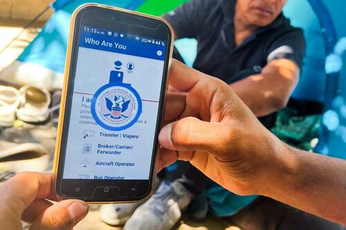
The official app which allows illegal immigrants to schedule appointments with the agency at U.S. ports of entry is plagued with technical issues and security vulnerabilities, according to a new report by the Homeland Security watchdog.
The report into the U.S. Customs and Border Protection’s (CBP) phone appointment app known as CBP One was published on Aug. 19 and sent to Congress.
The Department of Homeland Security’s Office of Inspector General (OIG) report examined whether or not CBP adequately planned and implemented the phone app to process migrants who arrive at the southwest border seeking entry into the United States.
The OIG found that while CBP initially addressed weaknesses in the app after its implementation, the agency failed to formally assess and mitigate the “technological risks involved with expanding the application” to allow immigrants to schedule appointments to present themselves for processing at the Southwest Border.”
“We found that CBP did not initially consider critical factors such as the design of the CBP One Genuine Presence functionality, adequacy of supporting application infrastructure, sufficiency of language translations, and equity of appointment distribution,” the report states.
“As a result, noncitizens initially using the new feature experienced application crashes, received frequent error messages, faced language barriers, and may not have always had an equal opportunity to secure an appointment,” it continues.
CBP’s One phone app was created in 2020 to serve as a single portal for various CBP services.
However, it was expanded in January 2023 under President Joe Biden’s administration to allow immigrants seeking to enter the United States to submit information and schedule appointments before arriving at one of eight points of entry along the southwest border.
The expansion was part of the administration’s efforts to discourage illegal border crossings by providing legal pathways.
According to a July press release from CBP, the app has “increased CBP’s capacity to process immigrants more efficiently and orderly while cutting out unscrupulous smugglers who endanger and profit from vulnerable migrants.”
In July alone, the federal agency processed over 38,000 individuals with appointments at ports of entry through the app.
Since the app’s appointment-scheduling function was introduced in January 2023 through the end of July 2024, more than 765,000 individuals have “successfully scheduled appointments to present at ports of entry instead of risking their lives in the hands of smugglers,” CBP said.
Security Vulnerabilities, Identical Address Claims
However, the OIG said it found CBP may also be failing to use information submitted to the app by immigrants before they arrive at the border to improve pre-arrival vetting procedures.
While the agency uses biographic and biometric information submitted into the app in advance to determine whether arriving migrants have “derogatory records,” it “does not leverage the information to identify suspicious trends as part of its pre-arrival vetting procedures,” according to the report.
Elsewhere, the OIG said it had identified potentially unrelated immigrants who repeatedly claimed identical intended U.S. residences.
“CBP currently does not have a mechanism to routinely analyze CBP One data submitted across the eligible POEs [points of entry] for trends, which may be useful intelligence to help guide front-line CBP officers when interviewing noncitizens during appointment processing,” the report said.
Meanwhile, the OIG report found security vulnerabilities within the application and its supporting infrastructure operating systems.
“Without a process to ensure all corrective security patches are timely implemented and assets are properly configured, data on the app may be susceptible to exploitation or cyber-attacks,” the report found.
“This process is especially important as CBP continues to update the application,” it added.
In concluding its report, the OIG recommended that CBP develop and implement a formalized risk assessment process when developing, expanding, or modifying mobile applications.
It also recommended that it introduce a mechanism to analyze the app’s advanced information for trends and patterns of fraudulent behaviors by users and communicate those results to the eight ports of entry that process appointments booked through the app.
The OIG further recommended that CBP introduce a mechanism to routinely assess CBP applications and supporting infrastructure operating systems for vulnerabilities and ensure corrective actions are undertaken in a timely manner.
CBP concurred with all three recommendations and promised to take corrective actions, according to the report.
The Epoch Times has contacted CBP for comment.
Loading…
Originally Posted at; https://www.zerohedge.com//
Stay Updated with news.freeptomaineradio.com’s Daily Newsletter
Stay informed! Subscribe to our daily newsletter to receive updates on our latest blog posts directly in your inbox. Don’t let important information get buried by big tech.
Current subscribers:

Report: Trump Campaign to Ramp Up Strategy Ahead of Election
The Trump campaign is reportedly planning to ramp up its strategy in the 2024 presidential election and increase the former president’s events and debate skills, according to several sources.
Several sources familiar with the plan explained to CNN that the Trump campaign will be increasing events on former President Donald Trump’s schedule, working to improve his debate skills, among other things.
This comes as Robert F. Kennedy Jr. recently announced that he is suspending his campaign and endorsing Trump, and as the former president has held events in states such as Pennsylvania and Arizona.
One adviser predicted that Trump would hold “several events each week, if not daily.”
“Think Trump on steroids,” another adviser told the outlet. “It’ll be all hands on deck.”
The outlet noted that this week Trump would be holding an event in Detroit, Michigan, where he will speak at the National Guard Association of the United States conference, and he will also be in Wisconsin and Pennsylvania:
On Monday, the former president will address the National Guard Association’s conference in Detroit; on Thursday, he will travel to Michigan for a speech on the economy before participating in a town hall in Wisconsin that evening. On Friday, he will hold a rally in Pennsylvania, then head to Washington, DC, to speak at the “Joyful Warriors” summit, held by the conservative Moms for Liberty group.
The former president has reportedly also been taking part in “policy discussions” with lawmakers and policy experts ahead of the presidential debate between Trump and Vice President Kamala Harris on September 10, the sources explained to the outlet.
Another Trump adviser explained that the debate prep for Trump would not “be any different” than the debate prep Trump had gone through ahead of the presidential debate on June 27 between him and President Joe Biden.
“It won’t be any different this time around,” the adviser explained to the outlet. “It worked well for him last time. If it ain’t broke, don’t fix it.”
The sources added that former Rep. Tulsi Gabbard (I-HI) is reportedly helping Trump to prepare for his debate with Vice President Kamala Harris and “understand” her “debate style,” according to the outlet.
Trump initially suggested three dates for Harris and the former president to take part in. The Harris campaign later announced that the vice president had only promised to take part in two debates.
Harris and Trump will take part in the September 10 debate as well as another debate in October.
Originally Posted At www.breitbart.com
Stay Updated with news.freeptomaineradio.com’s Daily Newsletter
Stay informed! Subscribe to our daily newsletter to receive updates on our latest blog posts directly in your inbox. Don’t let important information get buried by big tech.
Current subscribers:

SpaceX to Rescue Astronauts Stranded in Space on Boeing Starliner
Elon Musk’s SpaceX will rescue two astronauts who have been stranded in space since June after their Boeing Starliner spacecraft encountered problems.
NASA administrator Bill Nelson announced at a press conference on Saturday that astronauts Butch Wilmore and Sunita Williams will return to Earth in February of next year on the SpaceX Crew-9 mission.
Wilmore and Williams have been stranded aboard the International Space Station (ISS) since their Starliner spacecraft experienced five thruster malfunctions and five helium leaks.
“NASA has decided that Butch and Sunni will return with Crew-9 next February, and that Starliner will return uncrewed,” Nelson explained.
The astronauts blasted off from Florida on June 5, and they were initially slated to return to Earth on June 13. However, NASA later announced on June 18 that they were looking to bring the astronauts home on June 26.
During the astronauts’ 25-hour flight to space, engineers realized that the Starliner spacecraft was experiencing problems with its thrusters and experiencing helium leaks.
“Space flight is risky, even at its safest and even at its most routine,” Nelson said. “And a test flight, by nature, is neither safe nor routine. The decision to keep Butch and Suni aboard the International Space Station, and bring the Boeing Starliner home, uncrewed, is the result of a commitment to safety.”
Boeing employees labeled the decision to have SpaceX rescue the NASA astronauts as being “shameful.”
“We have had so many embarrassments lately, we’re under a microscope,” one Boeing employee told the New York Post. “This just made it, like, 100 times worse.”
The employee added that the Boeing employees hate SpaceX and added that they “talk s**t about them all the time.”
“It’s shameful,” he added. “I’m embarrassed, I’m horrified.”
NASA previously announced at the beginning of August that it was “evaluating all options for the return” of Williams and Wilmore.
Originally Posted At www.breitbart.com
Stay Updated with news.freeptomaineradio.com’s Daily Newsletter
Stay informed! Subscribe to our daily newsletter to receive updates on our latest blog posts directly in your inbox. Don’t let important information get buried by big tech.
Current subscribers:


