
Arm yourself with the Wellness Company’s Contagion Emergency Kit and face the season with a healthy dose of skepticism and a solid plan.
The post Election Pandemic Playbook: Don’t Get Fooled Again appeared first on Breitbart.

Arm yourself with the Wellness Company’s Contagion Emergency Kit and face the season with a healthy dose of skepticism and a solid plan.
The post Election Pandemic Playbook: Don’t Get Fooled Again appeared first on Breitbart.

from Your News: NASA’s diversity, equity, and inclusion (DEI) training has come under fire for suggesting that traits like ‘objectivity’ and ‘individualism’ are linked to white supremacy, sparking widespread criticism. By yourNEWS Media Newsroom NASA’s diversity, equity, and inclusion (DEI) training is facing sharp criticism after a video surfaced online linking concepts such as ‘objectivity’ […]

The flurry of post-Watergate “reforms” supposedly were passed to counteract government abuse of citizens. Not surprisingly, the FISA program, which was aimed at reducing internal government spying became the means of massive growth of the surveillance state.

by Brian Shilhavy, Health Impact News: Before I start writing about the headline news event from this past weekend where the founder of the Telegram platform was arrested in France, I think it is helpful to first define a term that is being used with almost all of the coverage of this event in the […]
Just as the Harris/Walz campaign was looking for a boost from the content-free Democratic National Convention last week, real drama broke out.
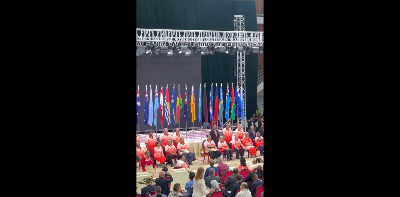
Pacific Island leaders endorsed a landmark regional policing plan Wednesday at a summit in Tonga, a contentious move seen as trying to limit China’s security role in the region. Leaders unveiled a plan to create up to four regional police training centres and a multinational crisis reaction force, backed by $271 million in initial funding […]
The post Pacific Island leaders endorse joint policing plan appeared first on Insider Paper.
Issued at 0900 UTC WED AUG 28 2024
…HONE CONTINUES WESTWARD WITH LITTLE CHANGE IN STRENGTH…
As of 11:00 PM HST Tue Aug 27
the center of Hone was located near 20.4, -167.8
with movement W at 10 mph.
The minimum central pressure was 1002 mb
with maximum sustained winds of about 50 mph.
Issued at 1100 PM HST Tue Aug 27 2024
296
WTPA41 PHFO 280847
TCDCP1

Tropical Storm Hone Discussion Number  24
NWS Central Pacific Hurricane Center Honolulu HI   CP012024
1100 PM HST Tue Aug 27 2024

The low-level circulation center of Hone became exposed earlier
this evening, due to increasingly strong westerly vertical wind
shear of around 35 knots. Even though the LLCC is displaced to the
west of the persistent deep convection, the latest subjective
Dvorak current intensity estimates remain between 2.5 (35 kt) and
3.5 (55 kt). As a result, the initial intensity has been held at 45
kt for this advisory.

Hone continues to move just north of due west or 280/9 kt. This
general motion is expected to continue during the next couple of
days as the cyclone is steered by a low to mid-level ridge to the
north. The motion is a bit more uncertain by the weekend as the
system begins to interact with a mid-level low near the
International Date Line. The track forecast calls for a slowing in
forward speed and a turn toward the northwest as a result of this
interaction. Little change was made to the track forecast during
the next couple days, followed by a nudge to the north over the
weekend to better align with the latest dynamical and consensus
guidance.

Strong westerly vertical wind shear of around 40 kt is forecast to
affect Hone during the next few days. This combined with dry
mid-level air surrounding the system should result in gradual
weakening despite the cyclone moving over increasingly warm sea
surface temperatures and higher ocean heat content. The intensity
forecast calls for slow weakening of the system, with Hone
forecast to become a post-tropical low by Friday, and dissipate on
Sunday. Little change was made to the intensity forecast which
remains closely aligned with the latest intensity consensus
guidance.


FORECAST POSITIONS AND MAX WINDS

INIT  28/0900Z 20.4N 167.8W   45 KT  50 MPH
 12H  28/1800Z 20.7N 169.1W   45 KT  50 MPH
 24H  29/0600Z 21.1N 170.9W   40 KT  45 MPH
 36H  29/1800Z 21.5N 172.7W   40 KT  45 MPH
 48H  30/0600Z 21.8N 174.3W   40 KT  45 MPH
 60H  30/1800Z 22.2N 175.5W   35 KT  40 MPH...POST-TROPICAL
 72H  31/0600Z 23.0N 176.5W   35 KT  40 MPH...POST-TROPICAL
 96H  01/0600Z 24.5N 178.0W   35 KT  40 MPH...POST-TROPICAL
120H  02/0600Z...DISSIPATED

$$
Forecaster Jelsema
Issued at 0900 UTC WED AUG 28 2024