


Former US Ambassador to USSR Says ‘Dangerous’ for US to Attempt Undeclared War With Russia
from Sputnik News:
WASHINGTON (Sputnik) – It is dangerous for the United States to attempt an undeclared war with Russia via Ukraine, former US Ambassador to the Soviet Union Jack Matlock said in an interview with the Schiller Institute.
“It seems to me that it is extremely dangerous to attempt what is, in effect, an undeclared war against a nuclear armed power, which perceives, rightly or wrongly, that its sovereignty and even its political existence are being threatened,” Matlock said in the interview, conducted on September 3 and released on Monday.
TRUTH LIVES on at https://sgtreport.tv/
Such a situation could result in a nuclear exchange between the United States and Russia because of mistakes, Matlock said.
US efforts to conduct diplomacy with Russia have disappeared and turned into feeding the conflict in Ukraine, Matlock said. Ukraine is on a “suicide course” by continuing hostilities with Russia, Matlock said.
Russia would not have launched its special military operation in Ukraine if the United States and NATO had given assurances that Ukraine would not join the alliance, Matlock said.
However, the United States has “grossly overcommitted” internationally by fueling de facto economic and military war against Russia, supporting Israel’s actions in the Middle East and preparing the US military for a war with China, Matlock said. The situation is sustainable neither economically nor militarily, Matlock also said.
Originally Posted at https://www.sgtreport.com
Stay Updated with news.freeptomaineradio.com’s Daily Newsletter
Stay informed! Subscribe to our daily newsletter to receive updates on our latest blog posts directly in your inbox. Don’t let important information get buried by big tech.
Current subscribers:

ABC News Fact-checked Trump 7 Times; Never Fact-checked Kamala Once
ABC News moderators Linsey Davis and David Muir intervened during Tuesday night’s presidential debate to “fact-check” former President Donald Trump at least seven times, but never did so with Vice President Kamala Harris.
Many of their fact-checks were incorrect or incomplete. A list of the seven most obvious examples follows (quotes taken from the ABC News transcript):
- LINSEY DAVIS: There is no state in this country where it is legal to kill a baby after it’s born. Madam vice president, I want to get your response to President Trump.
- DAVID MUIR: I just want to clarify here, you bring up Springfield, Ohio. And ABC News did reach out to the city manager there. He told us there have been no credible reports of specific claims of pets being harmed, injured or abused by individuals within the immigrant community
- DAVID MUIR: President Trump, as you know, the FBI says overall violent crime is coming down in this country…
- DAVID MUIR: The question was about you as president, not about Former Speaker Pelosi. But I do want Vice President Harris to respond here.
- DAVID MUIR: I did watch all of these pieces of video. I didn’t detect the sarcasm, lost by a whisker, we didn’t quite make it, and we should just point out as clarification, and you know this, you and your allies, 60 cases in front of many judges…
- DAVID MUIR: Mr. President, thank you. Vice President Harris, you heard the president there tonight. He said he didn’t say that he lost by a whisker. So he still believes he did not lose the election. That was won by President Biden and yourself.
- DAVID MUIR: President Trump, thank you. You did bring up something, you said she went to negotiate with Vladimir Putin. Vice President Harris, have you ever met Vladimir Putin, can you clarify tonight?
Harris resorted to many hoaxes in her remarks, notably the Charlottesville “very fine people” hoax, but neither Davis nor Muir bothered to intervene. The “fact-checking” was in one direction.
Joel B. Pollak is Senior Editor-at-Large at Breitbart News and the host of Breitbart News Sunday on Sirius XM Patriot on Sunday evenings from 7 p.m. to 10 p.m. ET (4 p.m. to 7 p.m. PT). He is the author of The Agenda: What Trump Should Do in His First 100 Days, available for pre-order on Amazon. He is also the author of The Trumpian Virtues: The Lessons and Legacy of Donald Trump’s Presidency, now available on Audible. He is a winner of the 2018 Robert Novak Journalism Alumni Fellowship. Follow him on Twitter at @joelpollak.
Originally Posted At www.breitbart.com
Stay Updated with news.freeptomaineradio.com’s Daily Newsletter
Stay informed! Subscribe to our daily newsletter to receive updates on our latest blog posts directly in your inbox. Don’t let important information get buried by big tech.
Current subscribers:
Hurricane Francine Public Advisory
000
WTNT31 KNHC 110854
TCPAT1

BULLETIN
Hurricane Francine Advisory Number  11
NWS National Hurricane Center Miami FL       AL062024
400 AM CDT Wed Sep 11 2024

...FRANCINE MOVING NORTHEASTWARD TOWARD THE LOUISIANA COAST...
...LIFE-THREATENING STORM SURGE AND HURRICANE-FORCE WINDS EXPECTED
TO BEGIN IN LOUISIANA LATER TODAY...


SUMMARY OF 400 AM CDT...0900 UTC...INFORMATION
----------------------------------------------
LOCATION...27.0N 93.8W
ABOUT 225 MI...360 KM ENE OF MOUTH OF THE RIO GRANDE
ABOUT 245 MI...395 KM SW OF MORGAN CITY LOUISIANA
MAXIMUM SUSTAINED WINDS...90 MPH...150 KM/H
PRESENT MOVEMENT...NE OR 35 DEGREES AT 10 MPH...17 KM/H
MINIMUM CENTRAL PRESSURE...977 MB...28.85 INCHES


WATCHES AND WARNINGS
--------------------
CHANGES WITH THIS ADVISORY:

None.

SUMMARY OF WATCHES AND WARNINGS IN EFFECT:

A Storm Surge Warning is in effect for...
* Cameron Louisiana to the Mississippi/Alabama Border
* Vermilion Bay
* Lake Maurepas
* Lake Pontchartrain

A Hurricane Warning is in effect for...
* The Louisiana coast from Vermilion/Cameron Line eastward to
Grand Isle

A Storm Surge Watch is in effect for...
* Mississippi/Alabama Border to the Alabama/Florida Border
* Mobile Bay

A Hurricane Watch is in effect for...
* Lake Maurepas and Lake Pontchartrain, including metropolitan New
Orleans

A Tropical Storm Warning is in effect for...
* Louisiana coast east of Sabine Pass to Vermilion/Cameron Line
* East of Grand Isle Louisiana to the Alabama/Florida border
* Lake Maurepas and Lake Pontchartrain, including metropolitan New
Orleans

A Storm Surge Warning means there is a danger of life-threatening
inundation, from rising water moving inland from the coastline,
during the next 36 hours in the indicated locations. A Storm Surge
Watch means there is a possibility of life-threatening inundation,
from rising water moving inland from the coastline, in the indicated
locations during the next 48 hours.

For a depiction of areas at risk, please see the National Weather
Service Storm Surge Watch/Warning Graphic, available at
hurricanes.gov.  This is a life-threatening situation.  Persons
located within these areas should take all necessary actions to
protect life and property from rising water and the potential for
other dangerous conditions.  Promptly follow evacuation and other
instructions from local officials.

A Hurricane Warning means that hurricane conditions are expected
somewhere within the warning area, in this case within 24 hours.
Preparations to protect life and property should be rushed to
completion.

A Hurricane Watch means that hurricane conditions are possible
within the watch area, in this case within 24 hours.

A Tropical Storm Warning means that tropical storm conditions are
expected somewhere within the warning area, in this case within
24 hours.

For storm information specific to your area, including possible
inland watches and warnings, please monitor products issued by your
local National Weather Service forecast office.


DISCUSSION AND OUTLOOK
----------------------
At 400 AM CDT (0900 UTC), the center of Hurricane Francine was
located near latitude 27.0 North, longitude 93.8 West. Francine is
moving toward the northeast near 10 mph (17 km/h). A faster
northeastward motion is expected today, and Francine is anticipated
to make landfall in Louisiana within the warning area this afternoon
or evening. After landfall, the center is expected to move northward
across Mississippi on Thursday and Thursday night.

Maximum sustained winds are near 90 mph (150 km/h) with higher
gusts. Some additional strengthening is expected this morning.
Francine is expected to weaken quickly after it moves inland.

Hurricane-force winds extend outward up to 40 miles (65 km) from the
center and tropical-storm-force winds extend outward up to 115 miles
(185 km).

The estimated minimum central pressure is 977 mb (28.85 inches).


HAZARDS AFFECTING LAND
----------------------
Key messages for Hurricane Francine can be found in the Tropical
Cyclone Discussion under AWIPS header MIATCDAT1 and WMO header
WTNT41 KNHC.

WIND:  Hurricane conditions are expected within the hurricane
warning area this afternoon, with tropical storm conditions arriving
in the warning area this morning. Hurricane conditions are possible
in the hurricane watch area this afternoon and tonight.

Tropical storm conditions are expected in the warning area along the
coasts of Louisiana, Mississippi, and Alabama today and tonight.

RAINFALL:  Francine is expected to bring storm total rainfall of 4
to 8 inches, with local amounts to 12 inches across southeastern
Louisiana, Mississippi, far southern Alabama, and the Florida
Panhandle through Thursday night. This rainfall could lead to
considerable flash and urban flooding.

For a complete depiction of forecast rainfall associated with
Francine, please see the National Weather Service Storm Total
Rainfall Graphic, available at
hurricanes.gov/graphics_at1.shtml?rainqpf and the Flash Flood Risk
graphic at hurricanes.gov/graphics_at1.shtml?ero.

STORM SURGE:  The combination of a dangerous storm surge and the
tide will cause normally dry areas near the coast to be flooded by
rising waters moving inland from the shoreline.  The water could
reach the following heights above ground somewhere in the indicated
areas if the peak surge occurs at the time of high tide...

Intracoastal City, LA to Port Fourchon, LA...5-10 ft
Vermilion Bay...5-10 ft
Port Fourchon, LA to Mouth of the Mississippi River, LA...4-7 ft
Mouth of the Pearl River, LA to Ocean Springs, MS...4-6 ft
Lake Pontchartrain...4-6 ft
Ocean Springs, MS to MS/AL Border...3-5 ft
Cameron, LA to Intracoastal City, LA...3-5 ft
Lake Maurepas...3-5 ft

The deepest water will occur along the immediate coast near and to
the east of the landfall location, where the surge will be
accompanied by large and dangerous waves.  Surge-related flooding
depends on the relative timing of the surge and the tidal cycle, and
can vary greatly over short distances.  Storm surge is not expected
to pose a threat to the risk reduction system levees.  However,
there may be some overtopping of local levees.  For information
specific to your area, please see products issued by your local
National Weather Service forecast office.

For a complete depiction of areas at risk of storm surge inundation,
please see the National Weather Service Peak Storm Surge Graphic,
available at hurricanes.gov/graphics_at1.shtml?peakSurge.

TORNADOES:  A few tornadoes are possible today and tonight across
parts of southeast Louisiana, southern Mississippi, southern
Alabama, and the Florida Panhandle.

SURF:  Swells generated by Francine are affecting much of the
northern and northwestern Gulf Coast, likely causing
life-threatening surf and rip current conditions. Please consult
products from your local weather office.


NEXT ADVISORY
-------------
Next intermediate advisory at 700 AM CDT.
Next complete advisory at 1000 AM CDT.

$$
Forecaster Reinhart
Originally Posted at:
NATIONAL HURRICANE CENTER and CENTRAL PACIFIC HURRICANE CENTER
At The NATIONAL OCEANIC AND ATMOSPHERIC ADMINISTRATION
Stay Updated with news.freeptomaineradio.com’s Daily Newsletter
Stay informed! Subscribe to our daily newsletter to receive updates on our latest blog posts directly in your inbox. Don’t let important information get buried by big tech.
Current subscribers:

Hurricane Francine Public Advisory
000
WTNT31 KNHC 110545
TCPAT1
BULLETIN
Hurricane Francine Intermediate Advisory Number 10A
National Weather Service National Hurricane Center Miami Florida AL062024
1:00 A.M. Central Daylight Time Wed Sep 11 2024
- FRANCINE A LITTLE STRONGER
- LIFE-THREATENING STORM SURGE AND HURRICANE-FORCE WINDS EXPECTED TO BEGIN IN LOUISIANA LATER TODAY
SUMMARY OF 1:00 A.M. Central Daylight Time 06:00 Coordinated Universal Time INFORMATION
LOCATION 26.6 NORTH 94.1 WEST
ABOUT 195 MILES, 315 KILOMETERS ENE OF MOUTH OF THE RIO GRANDE
ABOUT 275 MILES, 445 KILOMETERS SW OF MORGAN CITY LOUISIANA
MAXIMUM SUSTAINED WINDS 90 MILES PER HOUR 150 KILOMETERS PER HOUR
PRESENT MOVEMENT NE OR 35 DEGREES AT 10 MILES PER HOUR 17 KILOMETERS PER HOUR
MINIMUM CENTRAL PRESSURE 977 MILLIBAR, 28.85 INCHES
WATCHES AND WARNINGS
CHANGES WITH THIS ADVISORY:
None.
SUMMARY OF WATCHES AND WARNINGS IN EFFECT:
A Storm Surge Warning is in effect for
- Cameron Louisiana to the Mississippi/Alabama Border
- Vermilion Bay
- Lake Maurepas
- Lake Pontchartrain
A Hurricane Warning is in effect for
- The Louisiana coast from Vermilion/Cameron Line eastward to Grand Isle
A Storm Surge Watch is in effect for
- Mississippi/Alabama Border to the Alabama/Florida Border
- Mobile Bay
A Hurricane Watch is in effect for
- Lake Maurepas and Lake Pontchartrain, including metropolitan New Orleans
A Tropical Storm Warning is in effect for
- Louisiana coast east of Sabine Pass to Vermilion/Cameron Line
- East of Grand Isle Louisiana to the Alabama/Florida border
- Lake Maurepas and Lake Pontchartrain, including metropolitan New Orleans
- A Storm Surge Warning means there is a danger of life-threatening inundation, from rising water moving inland from the coastline, during the next 36 hours in the indicated locations.
- A Storm Surge Watch means there is a possibility of life-threatening inundation,from rising water moving inland from the coastline, in the indicated locations during the next 48 hours.
- For a depiction of areas at risk, please see the National Weather Service Storm Surge Watch/Warning Graphic, available at hurricanes.gov.
- This is a life-threatening situation.
- Persons located within these areas should take all necessary actions to protect life and property from rising water and the potential for other dangerous conditions.
- Promptly follow evacuation and other instructions from local officials.
- A Hurricane Warning means that hurricane conditions are expected somewhere within the warning area, in this case within 24 hours.
- Preparations to protect life and property should be rushed to completion.
- A Hurricane Watch means that hurricane conditions are possible within the watch area, in this case within 24 to 36 hours.
- A Tropical Storm Warning means that tropical storm conditions are expected somewhere within the warning area, in this case within 24 to 36 hours.
- For storm information specific to your area, including possible inland watches and warnings, please monitor products issued by your local National Weather Service forecast office.
DISCUSSION AND OUTLOOK
- At 1:00 A.M. Central Daylight Time (06:00 Coordinated Universal Time), the center of Hurricane Francine was located near latitude 26.6 North, longitude 94.1 West.
- Francine is moving toward the northeast near 10 MILESS PER HOUR (17 KILOMETERS PER HOUR).
- A faster northeastward motion is expected today, and Francine is anticipated to make landfall in Louisiana within the warning area this afternoon or evening.
- After landfall, the center is expected to move northward into Mississippi tonight and Thursday.
- Data from the Air Force Hurricane Hunters indicate that maximum sustained winds have increased to near 90 MILES PER HOUR (150 KILOMETERS PER HOUR) with higher gusts.
- Some additional strengthening is expected this morning.
- Francine is expected to weaken quickly after it moves inland.
- Hurricane-force winds extend outward up to 35 miles (55 KILOMETERS) from the center and tropical-storm-force winds extend outward up to 115 miles (185 KILOMETERS).
- The minimum central pressure based on data from the Air Force Hurricane Hunters is 977 MILLIBAR, (28.85 inches).
HAZARDS AFFECTING LAND
Key messages for Hurricane Francine can be found in the Tropical Cyclone Discussion under AWIPS header MIATCDAT1 and WMO header WTNT41 KNHC.
WIND:
- Hurricane conditions are expected within the hurricane warning area this afternoon, with tropical storm conditions arriving in the warning area this morning.
- Hurricane conditions are possible in the hurricane watch area this afternoon and tonight.
- Tropical storm conditions are expected in the warning area along the coasts of Louisiana, Mississippi, and Alabama today and tonight.
RAINFALL:
- Francine is expected to bring storm total rainfall of 4 to 8 inches, with local amounts to 12 inches across eastern Louisiana, Mississippi, far southern Alabama and the western Florida Panhandle through Friday morning.
- This rainfall could lead to considerable flash and urban flooding.
- For a complete depiction of forecast rainfall associated with Francine, please see the National Weather Service Storm Total Rainfall Graphic, available at
- and the Flash Flood Risk graphic at
STORM SURGE:
The combination of a dangerous storm surge and the tide will cause normally dry areas near the coast to be flooded by rising waters moving inland from the shoreline.
The water could reach the following heights above ground somewhere in the indicated areas if the peak surge occurs at the time of high tide
- Vermilion/Cameron Line, LOUISIANA to Port Fourchon, LOUISIANA 5 TO 10 feet
- Vermilion Bay 5 TO 10 feet
- Port Fourchon, LOUISIANA to Mouth of the Mississippi River, LOUISIANA 4 TO 7 feet
- Cameron, LOUISIANA to Vermilion/Cameron Line, LOUISIANA 3 TO 5 feet
- Pointe a la Hache, LOUISIANA to Mississippi/ALABAMA Border 3 TO 5 feet
- Lake Pontchartrain and Lake Maurepas 3 TO 5 feet
The deepest water will occur along the immediate coast near and to the east of the landfall location, where the surge will be accompanied by large and dangerous waves.
Surge-related flooding depends on the relative timing of the surge and the tidal cycle, and can vary greatly over short distances.
Storm surge is not expected to pose a threat to the risk reduction system levees.
However, there may be some overtopping of local levees.
For information specific to your area, please see products issued by your local National Weather Service forecast office.
For a complete depiction of areas at risk of storm surge inundation, please see the National Weather Service Peak Storm Surge Graphic, available at
TORNADOES:
- A few tornadoes are possible today into tonight across parts of southeast Louisiana, southern Mississippi, southern Alabama, and the Florida Panhandle.
SURF:
- Swells generated by Francine are affecting much of the northern and northwestern Gulf Coast, likely causing life-threatening surf and rip current conditions.
- Please consult products from your local weather office.
NEXT ADVISORY
Next complete advisory at 4:00 A.M. Central Daylight Time.
$$
Forecaster Reinhart
Originally Posted at:
NATIONAL HURRICANE CENTER and CENTRAL PACIFIC HURRICANE CENTER
At The NATIONAL OCEANIC AND ATMOSPHERIC ADMINISTRATION
Stay Updated with news.freeptomaineradio.com’s Daily Newsletter
Stay informed! Subscribe to our daily newsletter to receive updates on our latest blog posts directly in your inbox. Don’t let important information get buried by big tech.
Current subscribers:
Hurricane Francine Public Advisory
416
WTNT31 KNHC 110231
TCPAT1

BULLETIN
Hurricane Francine Advisory Number  10
NWS National Hurricane Center Miami FL       AL062024
1000 PM CDT Tue Sep 10 2024

...FRANCINE MOVING TOWARD THE LOUISIANA COAST...
...LIFE-THREATENING STORM SURGE AND HURRICANE-FORCE WINDS EXPECTED
TO BEGIN IN LOUISIANA ON WEDNESDAY...


SUMMARY OF 1000 PM CDT...0300 UTC...INFORMATION
-----------------------------------------------
LOCATION...26.4N 94.3W
ABOUT 185 MI...295 KM ENE OF MOUTH OF THE RIO GRANDE
ABOUT 295 MI...475 KM SW OF MORGAN CITY LOUISIANA
MAXIMUM SUSTAINED WINDS...75 MPH...120 KM/H
PRESENT MOVEMENT...NE OR 35 DEGREES AT 10 MPH...17 KM/H
MINIMUM CENTRAL PRESSURE...980 MB...28.94 INCHES


WATCHES AND WARNINGS
--------------------
CHANGES WITH THIS ADVISORY:

The Tropical Storm Warning from High Island to Sabine Pass has been
discontinued.  The Hurricane Warning from Cameron to the
Vermilion/Cameron Line has been replaced with a Tropical Storm
Warning.

The Storm Surge Warning has been discontinued west of Cameron
Louisiana.

SUMMARY OF WATCHES AND WARNINGS IN EFFECT:

A Storm Surge Warning is in effect for...
* Cameron Louisiana to the Mississippi/Alabama Border
* Vermilion Bay
* Lake Maurepas
* Lake Pontchartrain

A Hurricane Warning is in effect for...
* The Louisiana coast from Vermilion/Cameron Line eastward to
Grand Isle

A Storm Surge Watch is in effect for...
* Mississippi/Alabama Border to the Alabama/Florida Border
* Mobile Bay

A Hurricane Watch is in effect for...
* Lake Maurepas and Lake Pontchartrain, including metropolitan New
Orleans

A Tropical Storm Warning is in effect for...
* Louisiana coast east of Sabine Pass to Vermilion/Cameron Line
* East of Grand Isle Louisiana to the Alabama/Florida border
* Lake Maurepas and Lake Pontchartrain, including metropolitan New
Orleans

A Storm Surge Warning means there is a danger of life-threatening
inundation, from rising water moving inland from the coastline,
during the next 36 hours in the indicated locations. A Storm Surge
Watch means there is a possibility of life-threatening inundation,
from rising water moving inland from the coastline, in the indicated
locations during the next 48 hours.

For a depiction of areas at risk, please see the National Weather
Service Storm Surge Watch/Warning Graphic, available at
hurricanes.gov.  This is a life-threatening situation.  Persons
located within these areas should take all necessary actions to
protect life and property from rising water and the potential for
other dangerous conditions.  Promptly follow evacuation and other
instructions from local officials.

A Hurricane Warning means that hurricane conditions are expected
somewhere within the warning area.  A warning is typically issued 36
hours before the anticipated first occurrence of
tropical-storm-force winds, conditions that make outside
preparations difficult or dangerous.  Preparations to protect life
and property should be rushed to completion.

A Hurricane Watch means that hurricane conditions are possible
within the watch area, in this case within 24 to 36 hours.

A Tropical Storm Warning means that tropical storm conditions are
expected somewhere within the warning area within 36 hours.

For storm information specific to your area, including possible
inland watches and warnings, please monitor products issued by your
local National Weather Service forecast office.


DISCUSSION AND OUTLOOK
----------------------
At 1000 PM CDT (0300 UTC), the center of Hurricane Francine was
located near latitude 26.4 North, longitude 94.3 West. Francine is
moving toward the northeast near 10 mph (17 km/h).   A faster
northeastward motion is expected through Wednesday.  On the forecast
track, Francine is anticipated to make landfall in Louisiana
Wednesday afternoon or evening. After landfall, the center is
expected to move northward into Mississippi Wednesday night and
Thursday.

Maximum sustained winds are near 75 mph (120 km/h) with higher
gusts.  Additional strengthening is expected through Wednesday
morning.  Francine is expected to weaken quickly after it
moves inland.

Hurricane-force winds extend outward up to 35 miles (55 km) from the
center and tropical-storm-force winds extend outward up to 115 miles
(185 km).

The minimum central pressure based on data from the Air Force and
NOAA Hurricane Hunters is 980 mb (28.94 inches).


HAZARDS AFFECTING LAND
----------------------
Key messages for Hurricane Francine can be found in the
Tropical Cyclone Discussion under AWIPS header MIATCDAT1 and WMO
header WTNT41 KNHC.

WIND: Hurricane conditions are expected within the hurricane
warning area Wednesday afternoon, with tropical storm conditions
arriving in the warning area Wednesday morning. Hurricane
conditions are possible in the Hurricane Watch area Wednesday
afternoon and Wednesday night.

Tropical storm conditions are expected in the warning area along
the coasts of Louisiana, Mississippi, and Alabama Wednesday and
Wednesday night.

RAINFALL:  Francine is expected to bring storm total rainfall of 4
to 8 inches, with local amounts to 12 inches across eastern
Louisiana, Mississippi, far southern Alabama and the western
Florida Panhandle through Friday morning. This rainfall could lead
to considerable flash and urban flooding.

For a complete depiction of forecast rainfall associated with
Francine, please see the National Weather Service Storm Total
Rainfall Graphic, available at
hurricanes.gov/graphics_at1.shtml?rainqpf and the Flash Flood Risk
graphic at hurricanes.gov/graphics_at1.shtml?ero.

STORM SURGE:  The combination of a dangerous storm surge and the
tide will cause normally dry areas near the coast to be flooded by
rising waters moving inland from the shoreline.  The water could
reach the following heights above ground somewhere in the indicated
areas if the peak surge occurs at the time of high tide...

Vermilion/Cameron Line, LA to Port Fourchon, LA...5-10 ft
Vermilion Bay...5-10 ft
Port Fourchon, LA to Mouth of the Mississippi River, LA...4-7 ft
Cameron, LA to Vermilion/Cameron Line, LA...3-5 ft
Pointe a la Hache, LA to MS/AL Border...3-5 ft
Lake Pontchartrain and Lake Maurepas...3-5 ft

The deepest water will occur along the immediate coast near and to
the east of the landfall location, where the surge will be
accompanied by large and dangerous waves.  Surge-related flooding
depends on the relative timing of the surge and the tidal cycle, and
can vary greatly over short distances.  Storm surge is not expected
to pose a threat to the risk reduction system levees.  However,
there may be some overtopping of local levees.  For information
specific to your area, please see products issued by your local
National Weather Service forecast office.

For a complete depiction of areas at risk of storm surge
inundation, please see the National Weather Service Peak
Storm Surge Graphic, available at
hurricanes.gov/graphics_at1.shtml?peakSurge.

TORNADOES:  A few tornadoes are possible Wednesday into Wednesday
night across parts of southeast Louisiana, southern Mississippi,
southern Alabama, and the Florida Panhandle.

SURF:  Swells generated by Francine are affecting much of the
northern and northwestern Gulf Coast.  These swells are likely
to cause life-threatening surf and rip current conditions. Please
consult products from your local weather office.


NEXT ADVISORY
-------------
Next intermediate advisory at 100 AM CDT.
Next complete advisory at 400 AM CDT.

$$
Forecaster Cangialosi/Hagen
Originally Posted at:
NATIONAL HURRICANE CENTER and CENTRAL PACIFIC HURRICANE CENTER
At The NATIONAL OCEANIC AND ATMOSPHERIC ADMINISTRATION
Stay Updated with news.freeptomaineradio.com’s Daily Newsletter
Stay informed! Subscribe to our daily newsletter to receive updates on our latest blog posts directly in your inbox. Don’t let important information get buried by big tech.
Current subscribers:
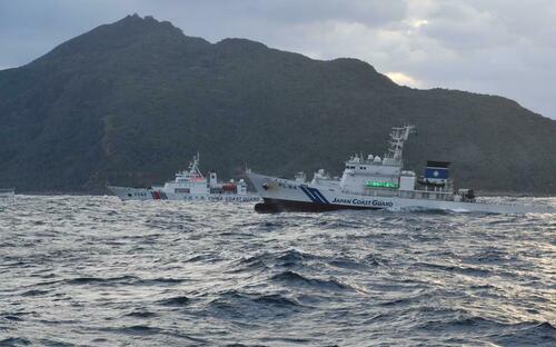
Japan Complains After Chinese Ships Armed With Machine Guns Sail Near Disputed Islets
By Keishi Koja of Stripes.com
Japan lodged another protest with China last week, its third in less than two weeks, after it said Chinese coast guard vessels entered waters around Japanese islets in the East China Sea.
Four vessels crossed the 12-mile territorial limit claimed by Japan around the Senkaku Islands between 4 p.m. and 4:06 p.m. Friday, according to a Japan coast guard news release that day.
Japan’s Foreign Affairs Ministry then lodged complaints with the Chinese Embassy in Japan and with the Chinese government in Beijing, a ministry spokesman told Stars and Stripes by phone Monday.
Some government officials in Japan are required to speak to the media only on condition of anonymity.
Two Chinese vessels approached Taisho Island from the northwest and entered the 12-mile limit at 4 p.m. and 4:06 p.m., according to the release.
Meanwhile, the remaining pair of Chinese vessels simultaneously entered the area around Uotsuri Island, also from the northwest.
The Chinese vessels appeared to be armed with deck-mounted machine guns and were met by a larger contingent of Japanese coast guard ships, a Japan coast guard spokesman told Stars and Stripes by phone Monday.
They warned the Chinese vessels to leave the area using radio and electronic message boards, he said.
“We do not know why the Chinese vessels intruded Japanese waters,” he said. “There were no Japanese fishing boats operating in the area.”
All four vessels left Japanese waters without incident by 6:01 p.m.
The incidents marked the 32nd and 33rd times this year that Chinese coast guard vessels intruded into Japan’s territorial waters around the Senkakus, the spokesman said. The last incident occurred Aug. 28.
The Senkakus are 105 miles east of Taiwan. The islets, whose surface area amounts to about 2½ square miles, are also claimed by China and Taiwan.
The incidents followed the intrusion of a Chinese military aircraft and a survey vessel into Japanese airspace and territorial waters around Kyushu, the southernmost of Japan’s four main islands, in late August.
A Chinese Y-9 surveillance plane flew into Japanese airspace on Aug. 26 just southeast of the Danjo Islands, about 100 miles southwest of Nagasaki. It was the first time a Chinese military aircraft breached Japan’s airspace.
The flight was a “grave violation” of Japan’s sovereignty and a threat to its security, Defense Minister Minoru Kihara said during a press conference Aug. 27.
“We filed extremely severe protests through diplomatic channels on the same day and strongly asked for measures to prevent recurrences,” he said.
Five days later, a Chinese naval survey vessel navigated into Japan’s territorial waters southwest of Kuchinoerabu Island, Kagoshima prefecture.
“We expressed strong concerns and filed a protest to the Chinese government through diplomatic channels on the same day,” Chief Cabinet Secretary Yoshimasa Hayashi said during a press conference Sept. 2.
U.S. Ambassador to Japan Rahm Emanuel questioned China’s intent on his account on social platform X.
“China says it’s still ‘investigating and verifying’ the recent violation of Japan’s airspace by one of its surveillance planes,” he wrote Sept. 3. “But with a Chinese survey ship sailing into Japanese waters only the other day, two territorial incursions in less than a week looks more intentional than accidental.”
Loading…
Originally Posted at; https://www.zerohedge.com//
Stay Updated with news.freeptomaineradio.com’s Daily Newsletter
Stay informed! Subscribe to our daily newsletter to receive updates on our latest blog posts directly in your inbox. Don’t let important information get buried by big tech.
Current subscribers:

Trump says it was his ‘best debate ever,’ accuses moderators of bias
Republican presidential candidate Donald Trump said his Tuesday showdown with Democrat Kamala Harris was his “best debate ever,” and accused the ABC network moderators of working against him.
“I thought that was my best Debate, EVER, especially since it was THREE ON ONE!” Trump posted on social media.
Stay Updated with news.freeptomaineradio.com’s Daily Newsletter
Stay informed! Subscribe to our daily newsletter to receive updates on our latest blog posts directly in your inbox. Don’t let important information get buried by big tech.
Current subscribers:

WATCH: Harris Makes Odd Facial Expressions While Debating Trump
Vice President Kamala Harris (D) exhibited odd facial expressions during the debate with former President Donald Trump on Tuesday in Philadelphia, Pennsylvania.
Social media users shared photos and videos that showed Harris’s reactions during the first half of the debate. One image caught the moment the vice president held her hand to her chin as she peered at Trump from across the stage:
In a video clip, Harris was seen throwing up her hand in reply as Trump spoke about policies. Harris appeared to say, “That’s not true, that’s not true,” while shaking her head:
In another clip, Harris was trying to emphasis a point about abortion when she lifted her eyebrows and moved her hands in a circular motion. She then turned to Trump with a scowl:
When Trump said, “She’s a Marxist, everybody knows she’s a Marxist,” Harris threw back her head as if to laugh off his comments:
A Quinnipiac poll released Monday showed Trump opened a four-point lead over Harris in Georgia, Breitbart News reported.
“The poll is significant because Harris is desperately trying to win Georgia to reduce Trump’s multiple paths to victory. Georgia was the first state Harris visited after the Democratic National Convention (DNC) in August,” the outlet said.
In addition, a poll published Tuesday showed Trump and Harris were neck and neck nationally. However, Trump has the momentum after surging three points in a month,” the Breitbart News article said.
Originally Posted At www.breitbart.com
Stay Updated with news.freeptomaineradio.com’s Daily Newsletter
Stay informed! Subscribe to our daily newsletter to receive updates on our latest blog posts directly in your inbox. Don’t let important information get buried by big tech.
Current subscribers:
Hurricane Francine Forecast Discussion
000
WTNT41 KNHC 110232
TCDAT1

Hurricane Francine Discussion Number  10
NWS National Hurricane Center Miami FL       AL062024
1000 PM CDT Tue Sep 10 2024

Both the NOAA and Air Force Hurricane Hunters have been
investigating Francine tonight, and the data they collected were the
basis for upgrading it to a hurricane a few hours ago.  The
maximum 700 mb flight-level wind measured was 76 kt, which supports
an intensity of about 65 kt.  The aircraft data also indicated that
the minimum pressure has fallen several millibars to 980 mb.  Deep
convection has been increasing near the center, and radar images
indicate that an inner core has developed.  There is still some dry
air, however, outside of the core region.

Francine is starting to move a little faster to the northeast, with
the latest initial motion estimated to be 035/9 kt.  A mid- to
upper-level trough over Texas is approaching the hurricane, and that
should cause it to accelerate northeastward toward the Louisiana
coast, with landfall expected there late Wednesday afternoon or
evening.  After Francine moves inland, a turn to the north-northeast
and a decrease in forward speed is predicted while it moves across
eastern Louisiana and Mississippi.  The models are in good
agreement, and little change was made to the previous track
forecast.

Now that Francine has a well organized core, significant
strengthening seems likely through Wednesday morning while the
system remains over very warm waters and in low wind shear
conditions.  The hurricane regional models are quite aggressive and
show Francine strengthening quickly, while the dynamical-statistical
models show much less intensification.  The NHC intensity forecast
is between those solutions and continues to show Francine nearing
category 2 strength Wednesday morning. A notable increase in shear
and intrusions of dry air should end the opportunity for
strengthening just before Francine reaches the coast. Rapid
weakening is expected after the cyclone moves inland.

An experimental cone graphic that includes inland Hurricane and
Tropical Storm Watches and Warnings in the U.S. is now available on
the NHC website. Due to the time needed to compile the inland watch
and warning information, the experimental cone graphic will not be
available as quickly as the operational cone. Once it is available,
the experimental cone graphic can be found from a red weblink above
the operational cone graphic at
www.nhc.noaa.gov/graphics_at1.shtml?cone#contents. Users are
encouraged to take the experimental product survey found below the
experimental cone.

KEY MESSAGES:

1. There is a danger of life-threatening storm surge on
Wednesday for the Louisiana and Mississippi coastlines, where a
Storm Surge Warning is in effect.  Residents in the warning area
should follow advice, including evacuation orders, given by local
officials.

2. Damaging and life-threatening hurricane-force winds are expected
in portions of southern Louisiana on Wednesday, where a Hurricane
Warning is in effect. Preparations to protect life and property
should be complete, since tropical storm conditions are expected to
begin within this area early Wednesday.

3. Francine is expected to bring heavy rainfall and the risk of
considerable flash and urban flooding across eastern Louisiana,
Mississippi, far southern Alabama and the western Florida Panhandle
through Thursday.  Flash and urban flooding is probable across the
Lower Tennessee Valley and Lower Mississippi Valley Wednesday night
into Friday morning.


FORECAST POSITIONS AND MAX WINDS

INIT  11/0300Z 26.4N  94.3W   65 KT  75 MPH
 12H  11/1200Z 27.7N  93.2W   80 KT  90 MPH
 24H  12/0000Z 29.7N  91.4W   80 KT  90 MPH...INLAND
 36H  12/1200Z 32.0N  90.2W   45 KT  50 MPH...INLAND
 48H  13/0000Z 34.2N  89.9W   30 KT  35 MPH...INLAND
 60H  13/1200Z 35.5N  89.9W   25 KT  30 MPH...POST-TROP/REMNT LOW
 72H  14/0000Z 36.3N  89.8W   25 KT  30 MPH...POST-TROP/REMNT LOW
 96H  15/0000Z...DISSIPATED

$$
Forecaster Cangialosi/Hagen
Originally Posted at:
NATIONAL HURRICANE CENTER and CENTRAL PACIFIC HURRICANE CENTER
At The NATIONAL OCEANIC AND ATMOSPHERIC ADMINISTRATION
Stay Updated with news.freeptomaineradio.com’s Daily Newsletter
Stay informed! Subscribe to our daily newsletter to receive updates on our latest blog posts directly in your inbox. Don’t let important information get buried by big tech.
Current subscribers:
Hurricane Francine Forecast Advisory
000
WTNT21 KNHC 110231
TCMAT1

HURRICANE FRANCINE FORECAST/ADVISORY NUMBER  10
NWS NATIONAL HURRICANE CENTER MIAMI FL       AL062024
0300 UTC WED SEP 11 2024

HURRICANE CENTER LOCATED NEAR 26.4N  94.3W AT 11/0300Z
POSITION ACCURATE WITHIN  20 NM

PRESENT MOVEMENT TOWARD THE NORTHEAST OR  35 DEGREES AT   9 KT

ESTIMATED MINIMUM CENTRAL PRESSURE  980 MB
MAX SUSTAINED WINDS  65 KT WITH GUSTS TO  80 KT.
64 KT....... 30NE  30SE   0SW   0NW.
50 KT....... 50NE  50SE  30SW  30NW.
34 KT....... 70NE 100SE  80SW  60NW.
12 FT SEAS..120NE 150SE 180SW 180NW.
WINDS AND SEAS VARY GREATLY IN EACH QUADRANT.  RADII IN NAUTICAL
MILES ARE THE LARGEST RADII EXPECTED ANYWHERE IN THAT QUADRANT.

REPEAT...CENTER LOCATED NEAR 26.4N  94.3W AT 11/0300Z
AT 11/0000Z CENTER WAS LOCATED NEAR 26.0N  94.7W

FORECAST VALID 11/1200Z 27.7N  93.2W
MAX WIND  80 KT...GUSTS 100 KT.
64 KT... 30NE  30SE  20SW  20NW.
50 KT... 50NE  50SE  40SW  40NW.
34 KT... 80NE 110SE  70SW  60NW.

FORECAST VALID 12/0000Z 29.7N  91.4W...INLAND
MAX WIND  80 KT...GUSTS 100 KT.
64 KT... 10NE  25SE  15SW   0NW.
50 KT... 40NE  50SE  40SW  20NW.
34 KT... 80NE 120SE  80SW  50NW.

FORECAST VALID 12/1200Z 32.0N  90.2W...INLAND
MAX WIND  45 KT...GUSTS  55 KT.
34 KT... 50NE 100SE   0SW   0NW.

FORECAST VALID 13/0000Z 34.2N  89.9W...INLAND
MAX WIND  30 KT...GUSTS  40 KT.

FORECAST VALID 13/1200Z 35.5N  89.9W...POST-TROP/REMNT LOW
MAX WIND  25 KT...GUSTS  35 KT.

FORECAST VALID 14/0000Z 36.3N  89.8W...POST-TROP/REMNT LOW
MAX WIND  25 KT...GUSTS  35 KT.

EXTENDED OUTLOOK. NOTE...ERRORS FOR TRACK HAVE AVERAGED NEAR 125 NM
ON DAY 4 AND 175 NM ON DAY 5...AND FOR INTENSITY NEAR 15 KT EACH DAY

OUTLOOK VALID 15/0000Z...DISSIPATED

REQUEST FOR 3 HOURLY SHIP REPORTS WITHIN 300 MILES OF 26.4N  94.3W

INTERMEDIATE PUBLIC ADVISORY...WTNT31 KNHC/MIATCPAT1...AT 11/0600Z

NEXT ADVISORY AT 11/0900Z

$$
FORECASTER CANGIALOSI
Originally Posted at:
NATIONAL HURRICANE CENTER and CENTRAL PACIFIC HURRICANE CENTER
At The NATIONAL OCEANIC AND ATMOSPHERIC ADMINISTRATION
Stay Updated with news.freeptomaineradio.com’s Daily Newsletter
Stay informed! Subscribe to our daily newsletter to receive updates on our latest blog posts directly in your inbox. Don’t let important information get buried by big tech.
Current subscribers: