


Our Moonshot Moment Is Here
Authored by Nadia Schadlow & Craig Mundie via The Epoch Times (emphasis ours),
American policymakers have spent years decrying the loss or impending loss of key competitive sectors to China, including 5G telecommunications networks, solar panels, advanced manufacturing, and quantum computing. Recently, it was reported that China was outspending the United States on fusion energy and that it could surpass U.S. fusion capabilities in three to four years. The United States can’t let this happen.
Fusion will provide reliable, carbon-free electricity for an expanding global economy. That will have profound geopolitical consequences. If we allow China to dominate fusion technology and to deploy it at scale at home and abroad, Beijing will hold a central position in the geopolitics of energy going forward.
Fusion occurs when two atoms combine into one, releasing astronomical amounts of energy. Some new fusion designs produce superheated plasma that can reach temperatures of up to 100 million degrees Celsius, producing energy with minimal radiation risks.
For generations, fusion has been the stuff of science fiction because of the challenge of recreating the physics of the sun in a controlled environment on earth. But in the last few years, scientists and engineers, working on competing models for producing fusion, have made transformational progress on several classes of daunting problems, faster than the public perceives. And faster than U.S. policy is reflecting.
Just as important as the physics behind these milestones are the advances in key “adjacent technologies” that help to manage the hot plasma at the heart of all fusion reactions. Advances in fiber optics, semiconductors, and computing, including AI, have been critical to progress. Power semiconductors have allowed the introduction of different fusion architectures, creating more opportunities and faster progress. Advanced fiber optics mean we don’t have to worry about electromagnetic interference. Powerful computers allow this intricate atomic ballet to be choreographed and repeated thousands of times per second.
Thanks to American innovation and determination, the fusion moment is here. When matched with private sector investment, it’s a potent force. But we could lose this moment to China unless the U.S. government takes steps now to accelerate manufacturing at scale and deployment.
First, fusion must be considered a considered a key part of the shift to clean energy. The focus for years has been almost exclusively on renewable solar and wind – which cannot solve the problem of intermittent energy. A Department of Energy report in 2022 advanced a U.S. strategy to secure supply chains for “Robust Clean Energy Transition” without mentioning fusion. The Biden Administration’s “Decadal Vision” for commercial fusion was a corrective, but fusion will need wider acceptance to take its place in the world’s energy mix.
Second, the U.S. government must create a regulatory environment that differentiates modern fusion technology from 20th century nuclear energy and that allows for scaled deployment. The Nuclear Regulatory Commission – which controls matters related to fission and fusion energy – has taken some important first steps. In April 2023, for example, it acknowledged that fusion energy should be treated as a technology separate from nuclear fission. Notably, the U.K. government also ruled on the “fundamental differences between nuclear fission and fusion” and that it would be “unnecessary to incorporate fusion energy facilities into nuclear regulation.” These are key steps toward a regulatory structure that would allow U.S. companies to produce fusion generators at scale. We can’t afford to wait 10 years to plan for power plants to come on-line. Just as our airline industry produces scores of airplane designs without having to separately approve each plane, U.S. fusion companies need to be able to manufacture generators in a repeatable way in large-scale factories to be effective.
Deploying fusion generators at scale will have the added benefit of catalyzing American manufacturing. But to achieve this, the U.S. needs to make the needed components. Most attention in the Act is focused on leading-edge microchips for computing – the kinds that are now primarily made in Taiwan. But it’s critical that the United States and its allies produce the kind of other semiconductors that enable the sophisticated physics synthesis required by fusion. Currently, a large majority of high-power semiconductor production and innovation takes place outside the United States.
Third, loan programs and tax incentives that apply to renewables need to be opened up to fusion. Currently for example, the production tax credit for manufacturing is geared towards renewables and does not include fusion. These programs and various Department of Energy efforts, while well-funded, need to prioritize fusion.
In the 19th century, the great powers scrambled to develop technology and secure petroleum supplies around the globe to ensure a secure foothold in the energy future. Today, a similar scramble is unfolding. Electrification for economic growth coupled with the new energy requirements of generative AI – which are immense – together will have critical geostrategic consequences. Beijing recognizes that fusion is a source of near-unlimited energy and that achieving it at scale will not only give China the energy independence it craves but also a leading position as supplier of these new sources of energy around the world.
Fusion is a moonshot opportunity. We can’t afford to miss it.
Nadia Schadlow is a Senior Fellow at the Hudson Institute. Craig Mundie was formerly the Chief Research and Strategy Officer at Microsoft. Both are strategic advisors to Helion Energy, a U.S. based fusion energy company.
Loading…
Originally Posted at; https://www.zerohedge.com//
Stay Updated with news.freeptomaineradio.com’s Daily Newsletter
Stay informed! Subscribe to our daily newsletter to receive updates on our latest blog posts directly in your inbox. Don’t let important information get buried by big tech.
Current subscribers:
Tropical Depression Seven Forecast Discussion
491
WTNT42 KNHC 130253
TCDAT2

Tropical Depression Seven Discussion Number   7
NWS National Hurricane Center Miami FL       AL072024
1100 PM AST Thu Sep 12 2024

The depression has been holding steady this evening.  After a lull
in the convective activity which exposed the low-level circulation,
thunderstorms have been building steadily to the east of the center.
Unfortunately, the scatterometer pass missed the core of the system
once again.  The initial intensity remains at 30 kt, close to the
subjective Dvorak estimates from TAFB and SAB.

A subtropical ridge to the north of the depression is steering the
system west-northwestward at about 14 kt.  As the ridge weakens
during the next few days, the cyclone should gradually slow and turn
more westward.  There is still a large spread in the track guidance
envelope early next week, which seems partially related to the depth
of the vortex.  The ECMWF solution shows a much stronger system that
turns the cyclone to the north sooner compared to the GFS and
GFS-based regional models showing a weaker system that moves faster
and stays in the low-level westerly flow.  The latest NHC track
forecast has been nudged a little to the south and lies between the
previous prediction and the consensus aids.

Marginal environmental conditions appear to be preventing the
depression from making any appreciable intensity changes.  Visible
satellite imagery from earlier today showed a band of Saharan dust
wrapping around the northern semicircle of the circulation.  The
intensity guidance has shifted downward again this cycle, with many
models showing a steady-to-weakening system over the next 3-4 days.
By the end of the forecast period, there is quite a bit of spread in
the intensity guidance as noted earlier.  The latest NHC intensity
forecast has been decreased slightly but remains on the high side of
the various aids.


FORECAST POSITIONS AND MAX WINDS

INIT  13/0300Z 18.7N  37.0W   30 KT  35 MPH
 12H  13/1200Z 19.1N  38.5W   35 KT  40 MPH
 24H  14/0000Z 19.4N  40.7W   35 KT  40 MPH
 36H  14/1200Z 19.7N  42.4W   35 KT  40 MPH
 48H  15/0000Z 19.7N  44.0W   35 KT  40 MPH
 60H  15/1200Z 19.7N  45.6W   35 KT  40 MPH
 72H  16/0000Z 19.6N  47.2W   35 KT  40 MPH
 96H  17/0000Z 19.8N  49.1W   40 KT  45 MPH
120H  18/0000Z 20.5N  50.0W   45 KT  50 MPH

$$
Forecaster Bucci
Originally Posted at:
NATIONAL HURRICANE CENTER and CENTRAL PACIFIC HURRICANE CENTER
At The NATIONAL OCEANIC AND ATMOSPHERIC ADMINISTRATION
Stay Updated with news.freeptomaineradio.com’s Daily Newsletter
Stay informed! Subscribe to our daily newsletter to receive updates on our latest blog posts directly in your inbox. Don’t let important information get buried by big tech.
Current subscribers:
Tropical Depression Seven Forecast Advisory
130
WTNT22 KNHC 130252
TCMAT2

TROPICAL DEPRESSION SEVEN FORECAST/ADVISORY NUMBER   7
NWS NATIONAL HURRICANE CENTER MIAMI FL       AL072024
0300 UTC FRI SEP 13 2024

TROPICAL DEPRESSION CENTER LOCATED NEAR 18.7N  37.0W AT 13/0300Z
POSITION ACCURATE WITHIN  30 NM

PRESENT MOVEMENT TOWARD THE WEST-NORTHWEST OR 290 DEGREES AT  14 KT

ESTIMATED MINIMUM CENTRAL PRESSURE 1007 MB
MAX SUSTAINED WINDS  30 KT WITH GUSTS TO  40 KT.
12 FT SEAS.. 60NE   0SE   0SW  60NW.
WINDS AND SEAS VARY GREATLY IN EACH QUADRANT.  RADII IN NAUTICAL
MILES ARE THE LARGEST RADII EXPECTED ANYWHERE IN THAT QUADRANT.

REPEAT...CENTER LOCATED NEAR 18.7N  37.0W AT 13/0300Z
AT 13/0000Z CENTER WAS LOCATED NEAR 18.5N  36.5W

FORECAST VALID 13/1200Z 19.1N  38.5W
MAX WIND  35 KT...GUSTS  45 KT.
34 KT... 50NE   0SE   0SW   0NW.

FORECAST VALID 14/0000Z 19.4N  40.7W
MAX WIND  35 KT...GUSTS  45 KT.
34 KT... 60NE   0SE   0SW   0NW.

FORECAST VALID 14/1200Z 19.7N  42.4W
MAX WIND  35 KT...GUSTS  45 KT.
34 KT... 70NE   0SE   0SW  40NW.

FORECAST VALID 15/0000Z 19.7N  44.0W
MAX WIND  35 KT...GUSTS  45 KT.
34 KT... 70NE   0SE   0SW  40NW.

FORECAST VALID 15/1200Z 19.7N  45.6W
MAX WIND  35 KT...GUSTS  45 KT.
34 KT... 70NE   0SE   0SW  40NW.

FORECAST VALID 16/0000Z 19.6N  47.2W
MAX WIND  35 KT...GUSTS  45 KT.
34 KT... 70NE   0SE   0SW  40NW.

EXTENDED OUTLOOK. NOTE...ERRORS FOR TRACK HAVE AVERAGED NEAR 125 NM
ON DAY 4 AND 175 NM ON DAY 5...AND FOR INTENSITY NEAR 15 KT EACH DAY

OUTLOOK VALID 17/0000Z 19.8N  49.1W
MAX WIND  40 KT...GUSTS  50 KT.
34 KT... 70NE  40SE   0SW  40NW.

OUTLOOK VALID 18/0000Z 20.5N  50.0W
MAX WIND  45 KT...GUSTS  55 KT.
34 KT... 70NE  50SE  30SW  50NW.

REQUEST FOR 3 HOURLY SHIP REPORTS WITHIN 300 MILES OF 18.7N  37.0W

NEXT ADVISORY AT 13/0900Z

$$
FORECASTER BUCCI
Originally Posted at:
NATIONAL HURRICANE CENTER and CENTRAL PACIFIC HURRICANE CENTER
At The NATIONAL OCEANIC AND ATMOSPHERIC ADMINISTRATION
Stay Updated with news.freeptomaineradio.com’s Daily Newsletter
Stay informed! Subscribe to our daily newsletter to receive updates on our latest blog posts directly in your inbox. Don’t let important information get buried by big tech.
Current subscribers:
Tropical Depression Seven Public Advisory
129
WTNT32 KNHC 130252
TCPAT2

BULLETIN
Tropical Depression Seven Advisory Number   7
NWS National Hurricane Center Miami FL       AL072024
1100 PM AST Thu Sep 12 2024

...DEPRESSION HOLDING STEADY OVER THE CENTRAL TROPICAL ATLANTIC
OCEAN...


SUMMARY OF 1100 PM AST...0300 UTC...INFORMATION
-----------------------------------------------
LOCATION...18.7N 37.0W
ABOUT 875 MI...1410 KM WNW OF THE CABO VERDE ISLANDS
MAXIMUM SUSTAINED WINDS...35 MPH...55 KM/H
PRESENT MOVEMENT...WNW OR 290 DEGREES AT 16 MPH...26 KM/H
MINIMUM CENTRAL PRESSURE...1007 MB...29.74 INCHES


WATCHES AND WARNINGS
--------------------
There are no coastal watches or warnings in effect.


DISCUSSION AND OUTLOOK
----------------------
At 1100 PM AST (0300 UTC), the center of Tropical Depression Seven
was located near latitude 18.7 North, longitude 37.0 West. The
depression is moving toward the west-northwest near 16 mph (26
km/h), and a west-northwest to west motion at a slower forward speed
is anticipated over the next few days.

Maximum sustained winds are near 35 mph (55 km/h) with higher gusts.
Some slight strengthening is forecast during the next day or so,
and the depression could become a tropical storm by Friday.

The estimated minimum central pressure is 1007 mb (29.74 inches).


HAZARDS AFFECTING LAND
----------------------
None.


NEXT ADVISORY
-------------
Next complete advisory at 500 AM AST.

$$
Forecaster Bucci
Originally Posted at:
NATIONAL HURRICANE CENTER and CENTRAL PACIFIC HURRICANE CENTER
At The NATIONAL OCEANIC AND ATMOSPHERIC ADMINISTRATION
Stay Updated with news.freeptomaineradio.com’s Daily Newsletter
Stay informed! Subscribe to our daily newsletter to receive updates on our latest blog posts directly in your inbox. Don’t let important information get buried by big tech.
Current subscribers:
Tropical Storm Ileana Public Advisory
000
WTPZ34 KNHC 130232
TCPEP4

BULLETIN
Tropical Storm Ileana Advisory Number   3
NWS National Hurricane Center Miami FL       EP092024
800 PM MST Thu Sep 12 2024

...ILEANA A LITTLE STRONGER...
...TROPICAL-STORM-FORCE WINDS AND HEAVY RAINS EXPECTED TO BEGIN
IN BAJA CALIFORNIA SUR ON FRIDAY...


SUMMARY OF 800 PM MST...0300 UTC...INFORMATION
----------------------------------------------
LOCATION...21.0N 108.5W
ABOUT 160 MI...255 KM SE OF CABO SAN LUCAS MEXICO
MAXIMUM SUSTAINED WINDS...45 MPH...75 KM/H
PRESENT MOVEMENT...NNW OR 335 DEGREES AT 12 MPH...19 KM/H
MINIMUM CENTRAL PRESSURE...999 MB...29.50 INCHES


WATCHES AND WARNINGS
--------------------
CHANGES WITH THIS ADVISORY:

None

SUMMARY OF WATCHES AND WARNINGS IN EFFECT:

A Tropical Storm Warning is in effect for...
* West coast of Baja California Sur Mexico from Santa Fe southward
* East coast of Baja California Sur Mexico from San Evaristo
southward

A Tropical Storm Watch is in effect for...
* East coast of Baja California Sur Mexico north of San Evaristo to
Loreto
* Mainland Mexico from Topolobampo to Huatabampito

A Tropical Storm Warning means that tropical storm conditions are
expected somewhere within the warning area within 36 hours.

A Tropical Storm Watch means that tropical storm conditions are
possible within the watch area, generally within 48 hours.

Interests elsewhere in the Mexican states of Baja California Sur,
Sinaloa, and Sonora should closely monitor the progress of Tropical
Storm Ileana.

For storm information specific to your area, please monitor
products issued by your national meteorological service.


DISCUSSION AND OUTLOOK
----------------------
At 800 PM MST (0300 UTC), the center of Tropical Storm Ileana was
located near latitude 21.0 North, longitude 108.5 West. Ileana is
moving toward the north-northwest near 12 mph (19 km/h).  A slower
north-northwestward to northward motion is expected during the next
few days.  On the forecast track, Ileana is expected to move across
the southern portion of the Baja California peninsula on Friday and
over the Gulf of California this weekend.

Maximum sustained winds have increased to near 45 mph (75 km/h)
with higher gusts.  Some additional strengthening is possible
before Ileana reaches the Baja California peninsula.  However,
weakening is expected to begin by late Friday.

Tropical-storm-force winds extend outward up to 90 miles (150 km)
from the center.

The estimated minimum central pressure is 999 mb (29.50 inches).


HAZARDS AFFECTING LAND
----------------------
Key messages for Ileana can be found in the Tropical Cyclone
Discussion under AWIPS header MIATCDEP4 and WMO header WTPZ44 KNHC.

RAINFALL: Tropical Storm Ileana is expected to produce 4-6 inches
with localized higher amounts up to 8 inches across the coastal
areas of Michoacan, Colima, and Jalisco through early Friday. From
Friday through Sunday, Tropical Storm Ileana may result in 4-6
inches, with localized higher amounts up to 8 inches, across
southern Baja California. For northwest coastal Sinaloa, Tropical
Storm Ileana may produce between 6-8 inches with localized higher
amounts up to 12 inches. This heavy rainfall will bring a risk of
flash flooding and mudslides to portions of the area.

WIND: Tropical storm conditions are expected to first reach
the coast of the southern Baja California Peninsula within the
warning area Friday morning, making outside preparations difficult
or dangerous. Tropical storm conditions are possible within the
watch area by early Saturday.

SURF: Swells generated by Tropical Storm Ileana will affect portions
of the coast of west-central Mexico and the coast of the southern
Baja California Peninsula during the next couple of days. These
swells are likely to cause life-threatening surf and rip current
conditions.  Please consult products from your local weather office.


NEXT ADVISORY
-------------
Next intermediate advisory at 1100 PM MST.
Next complete advisory at 200 AM MST.

$$
Forecaster Cangialosi
Originally Posted at:
NATIONAL HURRICANE CENTER and CENTRAL PACIFIC HURRICANE CENTER At The NATIONAL OCEANIC AND ATMOSPHERIC ADMINISTRATION
Stay Updated with news.freeptomaineradio.com’s Daily Newsletter
Stay informed! Subscribe to our daily newsletter to receive updates on our latest blog posts directly in your inbox. Don’t let important information get buried by big tech.
Current subscribers:
Tropical Storm Ileana Forecast Advisory
829
WTPZ24 KNHC 130231
TCMEP4

TROPICAL STORM ILEANA FORECAST/ADVISORY NUMBER   3
NWS NATIONAL HURRICANE CENTER MIAMI FL       EP092024
0300 UTC FRI SEP 13 2024

TROPICAL STORM CENTER LOCATED NEAR 21.0N 108.5W AT 13/0300Z
POSITION ACCURATE WITHIN  40 NM

PRESENT MOVEMENT TOWARD THE NORTH-NORTHWEST OR 335 DEGREES AT  10 KT

ESTIMATED MINIMUM CENTRAL PRESSURE  999 MB
MAX SUSTAINED WINDS  40 KT WITH GUSTS TO  50 KT.
34 KT....... 80NE  60SE   0SW   0NW.
12 FT SEAS.. 75NE  45SE   0SW   0NW.
WINDS AND SEAS VARY GREATLY IN EACH QUADRANT.  RADII IN NAUTICAL
MILES ARE THE LARGEST RADII EXPECTED ANYWHERE IN THAT QUADRANT.

REPEAT...CENTER LOCATED NEAR 21.0N 108.5W AT 13/0300Z
AT 13/0000Z CENTER WAS LOCATED NEAR 20.6N 108.3W

FORECAST VALID 13/1200Z 22.3N 109.3W
MAX WIND  45 KT...GUSTS  55 KT.
34 KT... 80NE  60SE   0SW  30NW.

FORECAST VALID 14/0000Z 23.7N 109.9W...INLAND
MAX WIND  40 KT...GUSTS  50 KT.
34 KT... 70NE  50SE  30SW  30NW.

FORECAST VALID 14/1200Z 25.0N 110.1W...OVER WATER
MAX WIND  40 KT...GUSTS  50 KT.
34 KT... 50NE  40SE  20SW  30NW.

FORECAST VALID 15/0000Z 26.1N 110.2W
MAX WIND  35 KT...GUSTS  45 KT.
34 KT... 40NE  30SE   0SW   0NW.

FORECAST VALID 15/1200Z 27.0N 110.6W...POST-TROPICAL
MAX WIND  30 KT...GUSTS  40 KT.

FORECAST VALID 16/0000Z 27.9N 111.2W...POST-TROP/REMNT LOW
MAX WIND  25 KT...GUSTS  35 KT.

EXTENDED OUTLOOK. NOTE...ERRORS FOR TRACK HAVE AVERAGED NEAR 100 NM
ON DAY 4 AND 125 NM ON DAY 5...AND FOR INTENSITY NEAR 15 KT EACH DAY

OUTLOOK VALID 17/0000Z...DISSIPATED

REQUEST FOR 3 HOURLY SHIP REPORTS WITHIN 300 MILES OF 21.0N 108.5W

INTERMEDIATE PUBLIC ADVISORY...WTNT34 KNHC/MIATCPEP4...AT 13/0600Z

NEXT ADVISORY AT 13/0900Z

$$
FORECASTER CANGIALOSI
Originally Posted at:
NATIONAL HURRICANE CENTER and CENTRAL PACIFIC HURRICANE CENTER
At The NATIONAL OCEANIC AND ATMOSPHERIC ADMINISTRATION
Stay Updated with news.freeptomaineradio.com’s Daily Newsletter
Stay informed! Subscribe to our daily newsletter to receive updates on our latest blog posts directly in your inbox. Don’t let important information get buried by big tech.
Current subscribers:
Post-Tropical Cyclone Francine Public Advisory
760
WTNT31 KWNH 130230
TCPAT1

BULLETIN
Post-Tropical Cyclone Francine Advisory Number  18
NWS Weather Prediction Center College Park MD   AL062024
1000 PM CDT Thu Sep 12 2024

...POST-TROPICAL FRANCINE MOVED NORTHWEST TO THE MISSISSIPPI
RIVER...
...HEAVY RAINFALL THREAT TO CONTINUE ACROSS PORTIONS OF THE
MISSISSIPPI DELTA, ALABAMA, WESTERN GEORGIA, AND THE FLORIDA
PANHANDLE...


SUMMARY OF 1000 PM CDT...0300 UTC...INFORMATION
-----------------------------------------------
LOCATION...35.2N 90.9W
ABOUT 50 MI...85 KM W OF MEMPHIS TENNESSEE
MAXIMUM SUSTAINED WINDS...30 MPH...45 KM/H
PRESENT MOVEMENT...NW OR 320 DEGREES AT 6 MPH...9 KM/H
MINIMUM CENTRAL PRESSURE...998 MB...29.47 INCHES


WATCHES AND WARNINGS
--------------------
SUMMARY OF WATCHES IN EFFECT:

Flood Watches and Wind Advisories are in effect for portions of the
Mississippi Delta, Tennessee Valley, and Southeast.


DISCUSSION AND OUTLOOK
----------------------
At 1000 PM CDT (0300 UTC), the center of Post-Tropical Cyclone
Francine was located near latitude 35.2 North, longitude 90.9 West.
The post-tropical cyclone is moving toward the northwest near 6 mph
(9 km/h) and this motion is expected to slow down before the
post-tropical storm dissipates on Friday.

Maximum sustained winds are near 30 mph (45 km/h) with higher gusts.
Little change in strength is forecast during the next 48 hours.

The estimated minimum central pressure is 998 mb (29.47 inches).


HAZARDS AFFECTING LAND
----------------------
Key messages for Francine can be found in the Tropical Cyclone
Discussion under AWIPS header MIATCDAT1 and WMO header WTNT41 KNHC.

RAINFALL: Post-Tropical Storm Francine is expected to bring
additional rainfall amounts of 4 to 6 inches with isolated totals
around 8 inches across portions of central and northern Alabama,
western Tennessee, and the Florida Panhandle. Elsewhere, 2 to 4
inches of additional rainfall is expected across parts of northern
Mississippi, northeast Arkansas, southwest Kentucky, and western
Georgia. This rainfall could lead to considerable flash and urban
flooding.

For a complete depiction of forecast rainfall associated with
Francine, please see the National Weather Service Storm Total
Rainfall Graphic, available at
hurricanes.gov/graphics_at1.shtml?rainqpf and the Flash Flood Risk
graphic at hurricanes.gov/graphics_at1.shtml?ero.  For a list of
rainfall observations (and wind reports) associated this storm, see
the companion storm summary at WBCSCCNS1 with the WMO header ACUS41
KWBC or at the following link:
www.wpc.ncep.noaa.gov/discussions/nfdscc1.html.

WIND:  Wind Advisories are in effect across portions of eastern
Arkansas, western Tennessee, northern Mississippi, central
and northern Alabama, and northwest Georgia. A few gusts to 40 mph
are possible.


NEXT ADVISORY
-------------
Next complete advisory at 400 AM CDT.

$$
Forecaster Hurley
Originally Posted at:
NATIONAL HURRICANE CENTER and CENTRAL PACIFIC HURRICANE CENTER
At The NATIONAL OCEANIC AND ATMOSPHERIC ADMINISTRATION
Stay Updated with news.freeptomaineradio.com’s Daily Newsletter
Stay informed! Subscribe to our daily newsletter to receive updates on our latest blog posts directly in your inbox. Don’t let important information get buried by big tech.
Current subscribers:

Japan says scrambled jets after Russia aircraft circled country
Japan’s military said it scrambled fighter jets on Thursday after two Russian patrol planes flew in a circle around the country, but there was no violation of Japanese airspace.
The last time Russian military aircraft circled Japan was in 2019, a ministry official told AFP on Friday, but that incident involved bombers that did enter the nation’s airspace.
From Thursday morning to afternoon, the Russian Tu-142 aircraft flew from the sea between Japan and South Korea towards the southern Okinawa region, a defence ministry statement said.
They then went northwards over the Pacific Ocean to finish their journey off northern Hokkaido island, it added.
The planes also flew over an area subject to a territorial dispute between Japan and Russia, the official said.
“In response, we mobilised Air Self-Defence Force fighter jets on an emergency basis,” the ministry statement said.
Earlier this week, Russian and Chinese warships began joint drills in the Sea of Japan.
The drills are part of a major naval exercise that Russian President Vladimir Putin has described as the largest of its kind in three decades.
Stay Updated with news.freeptomaineradio.com’s Daily Newsletter
Stay informed! Subscribe to our daily newsletter to receive updates on our latest blog posts directly in your inbox. Don’t let important information get buried by big tech.
Current subscribers:

Trump Pledges to End Taxes on Overtime: ‘Hardest-Working Citizens’
Former President Donald Trump pledged to end taxes on overtime, referring to those workers as the “hardest-working citizens in our country.”
“I’m also announcing that as part of our additional tax cuts, we will end all taxes on overtime,” Trump said during a rally, prompting applause from those in attendance. “That gives people more of an incentive to work. It [makes it a lot easier for the companies] to get the people.”
Trump praised overtime workers for their hard work while lamenting that Washington has not “been looking out for them.”
“I went to some economists. Great ones. I said, ‘what do you think?’ They said, ‘It would be unbelievable, you’ll get a whole new workforce by getting that.’ No taxes on overtime,” he said. “The people who work overtime are among the hardest working citizens in our country, and for too long, no one in Washington has been looking out for them. Those are the people. They really work. They’re police officers. They’re nurses, factory workers, construction workers, truck drivers, and machine operators. It’s time for the working man and woman to finally catch a break and that’s what we’re doing, because this is a good one, and I think it’s going to be great for the country. So that’s why we will be saying that if you’re an overtime worker, when you pass 40 hours a week, your overtime hours will be tax free.”
Trump’s pledge to end overtime taxes comes after he pledged to end taxes on tips. His opponent, Vice President Kamala Harris, has made a similar pledge.
“It is my promise to everyone here when I am president we will continue to fight for working families, including to raise the minimum wage and eliminate taxes on tips for service and hospitality workers,” Harris said.
Originally Posted At www.breitbart.com
Stay Updated with news.freeptomaineradio.com’s Daily Newsletter
Stay informed! Subscribe to our daily newsletter to receive updates on our latest blog posts directly in your inbox. Don’t let important information get buried by big tech.
Current subscribers:

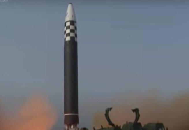
North Korea’s Kim Jong Un calls for boosting nuclear might
North Korean leader Kim Jong Un visited a nuclear facility and called for boosting the country’s nuclear capabilities in the face of growing threats from Washington and its allies, state media reported Friday.
The report comes a day after North Korea fired multiple short-range ballistic missiles into waters east of the Korean peninsula, Seoul’s military said, the nuclear-armed country’s first major weapons test since early July.
Kim inspected the Nuclear Weapons Institute and a production base of weapon-grade nuclear materials, the government news agency KCNA reported.
As he toured the facility, Kim “encouraged the nuclear scientists faithful to the Party to unconditionally implement the Party’s policy of building up nuclear force without an inch of deflection with their strong faith and high practical ability,” KCNA said.
Noting that nuclear threats from the United States and its allies “have become more undisguised and crossed the red line,” Kim said North Korea must “steadily expand and bolster up its defence capability… and the capability for a preemptive attack with the nuclear force as a pivot.”
Kim’s regime has staged dozens of launches this year, part of a testing spree experts say could be linked to North Korea’s alleged illicit supplying of weapons to ally Russia for use in Ukraine.
Pyongyang has denied any sanctions-busting weapons trade with Russia, but with diplomacy long stalled, it declared South Korea its “principal enemy” this year and recently moved nuclear-capable weapons to border areas.
Seoul’s Joint Chief of Staff said it had detected multiple “short-range ballistic missiles” fired early Thursday from Pyongyang into the East Sea, or Sea of Japan.
The missiles splashed down after flying around 360 kilometres (220 miles), the JCS said, adding it had “immediately detected, tracked, and monitored” the launch and was sharing information with allies Tokyo and Washington.
It said the test was “a clear provocation that seriously threatens peace and stability on the Korean Peninsula”.
Japan’s defence ministry also confirmed the missile test.
In an apparent reference to that test, KCNA reported Friday that Kim “oversaw the test-fire for verifying the performance of a new-type 600mm multiple rocket launcher.”
The shells “hit the target on an island in the East Sea,” according to KCNA.
“The test was conducted, aiming at further developing the launcher’s driving system and verifying the combat effectiveness of the launcher in which the whole process of firepower is fully automated,” it added.
Stay Updated with news.freeptomaineradio.com’s Daily Newsletter
Stay informed! Subscribe to our daily newsletter to receive updates on our latest blog posts directly in your inbox. Don’t let important information get buried by big tech.
Current subscribers: