Netflix is reportedly paying at least $60 million in purses to make history in its first-ever, live, non-pay-per-view sports broadcast tonight.
The streaming giant’s venture into live programming pits 27-year-old YouTuber-turned-boxer Jake Paul against 58 year-old ‘Iron’ Mike Tyson.
The big fight between “Iron Mike” and “The Problem Child” is scheduled to take place at AT&T Stadium, the Arlington, Texas home of the Dallas Cowboys.
The venue, which holds 80,000, has hosted some major boxing matches over the years, including multiple fights featuring former champion Manny Pacquiao current pound-for-pound No. 1 Canelo Álvarez.
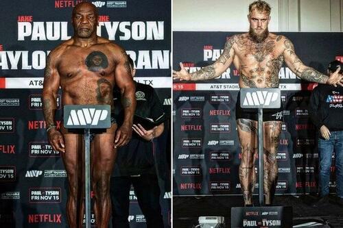
Tyson will be fighting out of the red corner on Friday night, and weighs in at 228.4 pounds.
“This fight is not going to change my lifestyle financially,” Tyson said.
“I feel I can beat this guy.”
Paul will fight from the blue corner of the ring and enters the fight at 227.2 pounds.
“I’m here to make $40m and knock out a legend,” Jake Paul told interviewers.
The fight has garnered a great deal of attention as nobody knows how a 58-year-old Mike Tyson is going to look in his first sanctioned competitive fight since 2005.
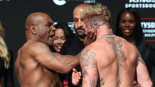
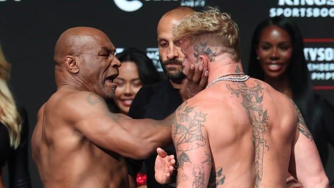
Things got a littel heated at the weigh-in…
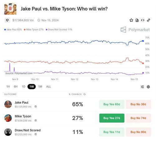
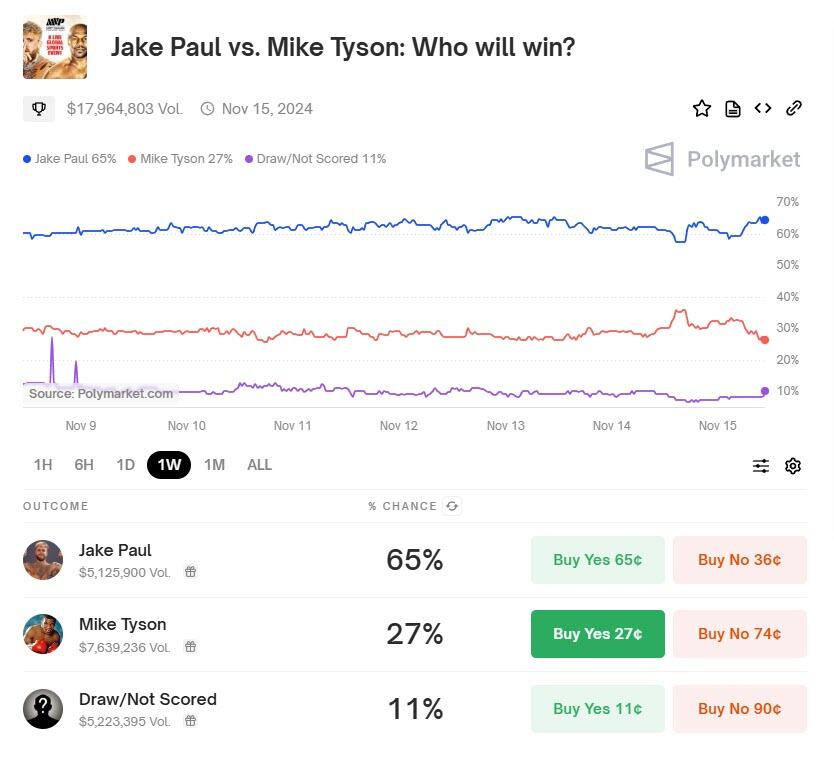
For now, the betting markets favor Paul over Iron Mike, with Tyson’s odds fading today…
Jake Paul’s Advantages:
-
Age and Stamina: Paul is significantly younger, at 27 years old, which gives him an edge in terms of stamina, recovery, and physical condition. Boxing is indeed a sport where youth can be a substantial advantage.
-
Recent Activity: Paul has been active in the ring, fighting several times in recent years. This regular competition keeps him in fighting shape and provides him with recent experience against diverse opponents.
-
Size and Reach: Paul has a height advantage and possibly a reach advantage, which could help him keep Tyson at bay if he chooses to fight more defensively.
-
Boxing Skill Development: Over his fights, Paul has shown improvement in his boxing technique, particularly in his footwork, jab usage, and defensive maneuvers.
Mike Tyson’s Advantages:
-
Experience: Tyson’s vast experience as a former undisputed heavyweight champion cannot be overstated. He knows how to fight at the highest levels, how to read opponents, and how to end fights quickly.
-
Power: Even at an advanced age, Tyson’s punching power is legendary. If he can land a clean shot, his power could still be devastating.
-
Motivation: This fight could serve as a significant motivator for Tyson to prove he still has what it takes, which might lead to an exceptional performance.
Fight Predictions:
Betting odds generally favor Paul due to his youth and recent activity, but there’s a significant portion of the public and some experts betting on Tyson, driven by nostalgia and his raw power.
-
Scenario 1 – Early Knockout: If Tyson can replicate his old explosive starts and land a significant punch early, he could potentially knock out Paul.
-
Scenario 2 – Endurance and Strategy: If the fight goes beyond the initial rounds, Paul’s superior conditioning and strategy might wear Tyson down, leading to a win either by knockout or decision.
-
Scenario 3 – Fight Integrity: There’s always the possibility in such high-profile, exhibition-like bouts that the fight might not be as competitive as it could be due to various external factors, but given the statements from both fighters and the sanctioning of the bout, this seems less likely.
Conclusion:
While many factors could play into the outcome, if one were to go by the majority of expert opinions and odds:
Jake Paul is likely to win due to his youth, recent fighting experience, and physical advantages. However, Mike Tyson’s power and experience make him a dangerous opponent, and if he can catch Paul with a solid punch, nothing can be ruled out.
The fight’s result might also depend on how Tyson has prepared, considering his age and health conditions.
Remember, in boxing, one punch can change everything, especially when it comes from someone with Tyson’s history.
* * *
Netflix will start coverage of the full fight card at 2000ET.
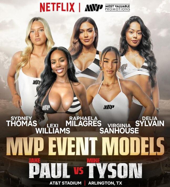
Who are the Jake Paul-Mike Tyson Ring Girls?

-
Lexi Williams – Instagram superstar; 1.4M followers; “I’m so excited to be a part of this moment,” she wrote on Instagram. One of the true titans of the Instagram modeling world
-
Sydney Thomas – Making her second career ring girl appearance
-
Raphaela Milagres – Brazilian model who worked the Jake Paul vs. Andre August fight in 2023
-
Virginia Sanhouse – Venezuelan model with 5.5M TikTok followers
-
Delia Sylvain – Veteran ring girl who worked the Jake Paul vs. Mike Perry fight in July.
Full Card:
-
Heavyweight: Mike Tyson vs. Jake Paul
-
Super Lightweight: Katie Taylor vs. Amanda Serrano for Taylor’s IBF, WBA, WBC and WBO women’s super-lightweight titles
-
Welterweight: Mario Barrios vs. Abel Ramos for Barrios’ WBC welterweight title
-
Super Middleweight: Neeraj Goyat vs. Whindersson Nunes
-
Super Middleweight: Shadasia Green vs Melinda Watpool for vacant women’s WBO super middleweight title
-
Super Lightweight: Lucas Bahdi vs. Armando Casamonica
-
Featherweight: Bruce Carrington vs Dana Coolwell
As PJMedia’s Scott Pinsker warns, make no mistake, Mike Tyson is still a master artist. He’s still an all-time great.
Jake Paul is scribbling with crayons.
On their merits, if Tyson has ANYTHING left, he will flatten Paul. It shouldn’t go more than a couple of rounds, two minutes or not. Mike Tyson on Testosterone Replacement Therapy is probably less like a guy pushing 60 and more like an athlete in his 40s.
If the fix is in, it’s almost certainly for Tyson to take the dive. That’s how it’s always been in boxing: The old lion makes way for the younger (and more marketable) lion.
Some boxing insiders suspect as much.
After all, Paul has exponentially more to lose: If Tyson loses, he’s still Mike Tyson, but if Paul loses, he’s done.

