
000
WTNT34 KNHC 091147
TCPAT4
BULLETIN
Hurricane Milton Intermediate Advisory Number 17A
National Weather Service National Hurricane Center Miami Florida AL142024
8:00 A.M. Eastern Daylight Time Wed Oct 09 2024
- WINDS WILL BEGIN TO INCREASE ALONG THE WEST COAST OF FLORIDA BY THIS AFTERNOON
- PREPARATIONS, INCLUDING EVACUATION IF TOLD TO DO SO, SHOULD BE RUSHED TO COMPLETION THIS MORNING
SUMMARY OF 8:00 A.M. Eastern Daylight Time 12:00 Coordinated Universal Time INFORMATION
LOCATION 25.0 North 84.8 West
ABOUT 120 Miles, 195 Kilometers West OF THE DRY TORTUGAS
ABOUT 250 Miles, 405 Kilometers Southwest OF TAMPA FLORIDA
MAXIMUM SUSTAINED WINDS 155 Miles Per Hour, 250 Kilometers Per Hour
PRESENT MOVEMENT Northeast OR 40 DEGREES AT 16 Miles Per Hour, 26 Kilometers Per Hour
MINIMUM CENTRAL PRESSURE 915 Millibar, 27.02 INCHES
WATCHES AND WARNINGS
CHANGES WITH THIS ADVISORY:
None.
SUMMARY OF WATCHES AND WARNINGS IN EFFECT:
A Storm Surge Warning is in effect for
- Florida west coast from Flamingo northward to Yankeetown, including Charlotte Harbor and Tampa Bay
- Sebastian Inlet Florida to Altamaha Sound Georgia, including the Saint Johns River
A Hurricane Warning is in effect for
- Florida west coast from Bonita Beach northward to Suwannee River, including Tampa Bay
- Florida east coast from the Saint Lucie/Martin County Line northward to Ponte Vedra Beach
A Storm Surge Watch is in effect for
- North of Altamaha Sound Georgia to Edisto Beach South Carolina
A Hurricane Watch is in effect for
- Dry Tortugas
- Lake Okeechobee
- Florida west coast from Chokoloskee to south of Bonita Beach
- Florida east coast north of Ponte Vedra Beach to the mouth of the Saint Marys River
- Florida east coast from the Saint Lucie/Martin County Line to the Palm Beach/Martin County Line
A Tropical Storm Warning is in effect for
- Florida Keys, including Dry Tortugas and Florida Bay
- Lake Okeechobee
- Florida west coast from Flamingo to south of Bonita Beach
- Florida west coast from north of Suwanee River to Indian Pass
- Florida east coast south of the Saint Lucie/Martin County Line to Flamingo
- North of Ponte Vedra Beach Florida to the Savannah River
- Extreme northwestern Bahamas, including Grand Bahama Island, the Abacos, and Bimini
A Tropical Storm Watch is in effect for
- North of the Savannah River to South Santee River South Carolina
- A Storm Surge Warning means there is a danger of life-threatening inundation, from rising water moving inland from the coastline, during the next 36 hours in the indicated locations.
- For a depiction of areas at risk, please see the National Weather Service Storm Surge Watch/Warning Graphic, available at hurricanes.gov.
- This is a life-threatening situation.
- Persons located within these areas should take all necessary actions to protect life and property from rising water and the potential for other dangerous conditions.
- Promptly follow evacuation and other instructions from local officials.
- A Hurricane Warning means that hurricane conditions are expected somewhere within the warning area.
- A warning is typically issued 36 hours before the anticipated first occurrence of tropical-storm-force winds, conditions that make outside preparations difficult or dangerous.
- Preparations to protect life and property should be rushed to completion.
- A Tropical Storm Warning means that tropical storm conditions are expected somewhere within the warning area within 36 hours.
- A Storm Surge Watch means there is a possibility of life-threatening inundation, from rising water moving inland from the coastline, in the indicated locations during the next 48 hours.
- For a depiction of areas at risk, please see the National Weather Service Storm Surge Watch/Warning Graphic, available at hurricanes.gov.
- A Hurricane Watch means that hurricane conditions are possible within the watch area.
- A watch is typically issued 48 hours before the anticipated first occurrence of tropical-storm-force winds, conditions that make outside preparations difficult or dangerous.
- A Tropical Storm Watch means that tropical storm conditions are possible within the watch area, generally within 48 hours.
- For storm information specific to your area in the United States, including possible inland watches and warnings, please monitor products issued by your local National Weather Service forecast office.
- For storm information specific to your area outside of the United States, please monitor products issued by your national meteorological service.
DISCUSSION AND OUTLOOK
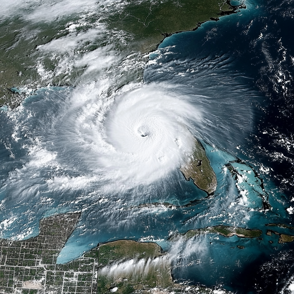
- At 8:00 A.M. Eastern Daylight Time (12:00 Coordinated Universal Time), the eye of Hurricane Milton was located near latitude 25.0 North, longitude 84.8 West.
- Milton is moving toward the northeast near 16 Miles Per Hour, (26 Kilometers Per Hour).
- A northeastward motion is expected through tonight.
- A turn toward the east-northeast and east is expected on Thursday and Friday.
- On the forecast track, the center of Milton will move across the eastern Gulf of Mexico today, make landfall along the west-central coast of Florida late tonight or early Thursday morning, and move off the east coast of Florida over the western Atlantic Ocean Thursday afternoon.
- Maximum sustained winds are near 155 Miles Per Hour, (250 Kilometers Per Hour) with higher gusts.
- Milton is a category 4 hurricane on the Saffir-Simpson Hurricane Wind Scale. Milton is expected to remain an extremely dangerous major hurricane when it reaches the west-central coast of Florida tonight.
- Hurricane-force winds extend outward up to 30 miles (45 Kilometers) from the center and tropical-storm-force winds extend outward up to 125 miles (205 Kilometers).
- The minimum central pressure based on NOAA and Air Force Reserve Hurricane Hunter data is 915 Millibar, (27.02 inches).
HAZARDS AFFECTING LAND
- Key Messages for Milton can be found in the Tropical Cyclone Discussion under AWIPS header MIATCDAT4 and WMO header WTNT44 KNHC and on the web at
hurricanes.gov/text/MIATCDAT4.shtml
STORM SURGE:
- The combination of a dangerous storm surge and the tide will cause normally dry areas near the coast to be flooded by rising waters moving inland from the shoreline.
- The water could reach the following heights above ground somewhere in the indicated areas if the peak surge occurs at the time of high tide
-
- Anna Maria Island, Florida to Boca Grande, Florida 10-15 feet
- Anclote River, Florida to Anna Maria Island, Florida 8-12 feet
- Tampa Bay 8-12 feet
- Boca Grande, Florida to Bonita Beach, Florida 8-12 feet
- Charlotte Harbor 8-12 feet
- Bonita Beach, Florida to Chokoloskee, Florida 5-8 feet
- Aripeka, Florida to Anclote River, Florida 4-7 feet
- Chokoloskee, Florida to Flamingo, Florida 3-5 feet
- Sebastian Inlet, Florida to Altamaha Sound, Georgia 3-5 feet
- Altamaha Sound, Georgia to Edisto Beach, South Carolina 2-4 feet
- Yankeetown, Florida to Aripeka, Florida 2-4 feet
- Dry Tortugas 2-4 feet
- Saint Johns River 2-4 feet
- The deepest water will occur along the immediate coast near and to the south of the landfall location, where the surge will be accompanied by large and dangerous waves.
- Surge-related flooding depends on the relative timing of the surge and the tidal cycle, and can vary greatly over short distances.
- For information specific to your area, please see products issued by your local National Weather Service forecast office.
- For a complete depiction of areas at risk of storm surge inundation, please see the National Weather Service Peak Storm Surge Graphic, available at
hurricanes.gov/graphics_at4.shtml?peakSurge
RAINFALL:
- Rainfall amounts of 6 to 12 inches, with localized totals up to 18 inches, are expected across central to northern portions of the Florida Peninsula through Thursday.
- This rainfall brings the risk of catastrophic and life-threatening flash and urban flooding, along with moderate to major river flooding.
- For a complete depiction of forecast rainfall associated with Hurricane Milton, please see the National Weather Service Storm Total Rainfall Graphic, available at
hurricanes.gov/graphics_at4.shtml?rainqpf
- and the Flash Flood Risk graphic at
hurricanes.gov/graphics_at4.shtml?ero
WIND:
- Hurricane conditions are expected in the hurricane warning area across Florida beginning this evening through early Thursday and are possible in the hurricane watch area on Thursday.
- Tropical storm conditions are expected to begin in the warning area on the west coast of Florida around midday, spreading across the peninsula and reaching the east coast tonight.
- Tropical storm conditions are expected to begin in the warning area on the east coast of Florida tonight and along the Georgia coast on Thursday.
- Tropical storm conditions are expected in portions of the northwestern Bahamas on Thursday.
- Tropical storm conditions are possible within the watch area on the South Carolina coast on Thursday.
TORNADOES:
- Several tornadoes are likely today and tonight across parts of central and southern Florida.
SURF:
- Swells generated by Milton are expected to continue to affect much of the Gulf Coast and will increase along the southeastern U.S. coast during the next day or two.
- These swells are likely to cause life-threatening surf and rip current conditions.
- Please consult products from your local weather office.
NEXT ADVISORY
Next complete advisory at 11:00 A.M. Eastern Daylight Time.
Hourly Tropical Cyclone Updates will begin at 9:00 A.M. Eastern Daylight Time (13:00 Coordinated Universal Time).
$$
Forecaster Berg
Originally Posted at:
NATIONAL HURRICANE CENTER and CENTRAL PACIFIC HURRICANE CENTER
At The NATIONAL OCEANIC AND ATMOSPHERIC ADMINISTRATION
Stay Updated with news.freeptomaineradio.com’s Daily Newsletter
Stay informed! Subscribe to our daily newsletter to receive updates on our latest blog posts directly in your inbox. Don’t let important information get buried by big tech.
Current subscribers:


