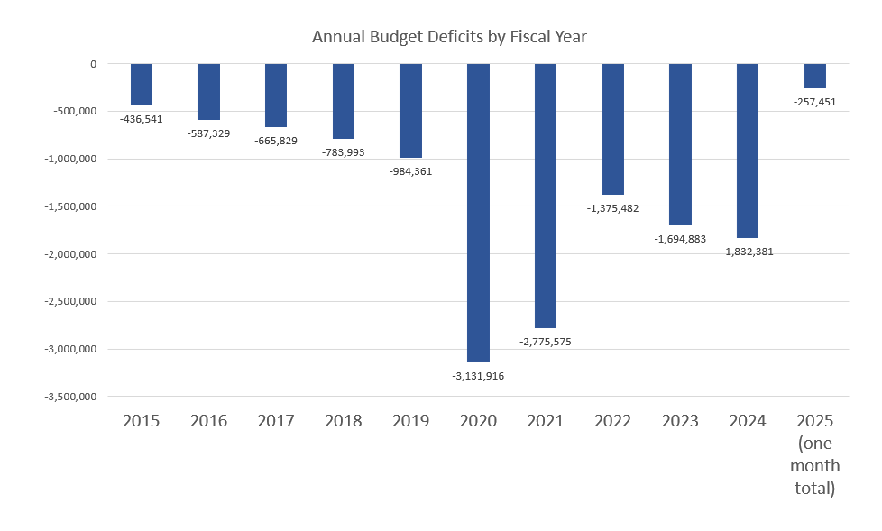
ZCZC MIATWOAT ALL
TTAA00 KNHC DDHHMM
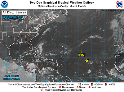
Tropical Weather Outlook
NWS National Hurricane Center Miami FL
800 AM EDT Mon Oct 14 2024
For the North Atlantic…Caribbean Sea and the Gulf of Mexico:
1. Central Tropical Atlantic (AL94):
A well-defined area of low pressure located several hundred miles
west of the Cabo Verde Islands is producing some disorganized
showers and thunderstorms. This system is currently embedded in a
dry environment, and development is unlikely over the next couple of
days. However, this system is forecast to move generally westward
toward warmer waters, and environmental conditions could become more
favorable for gradual development by the middle to latter part of
this week. A tropical depression could form as the system begins
moving west-northwestward and approaches or moves near the Leeward
Islands late this week.
* Formation chance through 48 hours…low…10 percent.
* Formation chance through 7 days…medium…50 percent.
Forecaster Hagen
Originally posted at:
NATIONAL HURRICANE CENTER and CENTRAL PACIFIC HURRICANE CENTER OF THE NATIONAL OCEANIC AND ATMOSPHERIC ADMINISTRATION
Stay Updated with news.freeptomaineradio.com’s Daily Newsletter
Stay informed! Subscribe to our daily newsletter to receive updates on our latest blog posts directly in your inbox. Don’t let important information get buried by big tech.
Current subscribers: