
Tropical Storm Francine Public Advisory
359
WTNT31 KNHC 100848
TCPAT1
BULLETIN
Tropical Storm Francine Advisory Number 7
National Weather Service National Hurricane Center Miami Florida AL062024
4:00 A.M. Central Daylight Time Tue Sep 10 2024
- FRANCINE LIKELY TO BECOME A HURRICANE TODAY
SUMMARY OF 4:00 A.M. Central Daylight Time 09:00 Coordinated Universal Time INFORMATION
LOCATION 24.4 North 96.2 West
ABOUT 120 Miles, 195 Kilometers SSE OF MOUTH OF THE RIO GRANDE
ABOUT 415 Miles, 665 Kilometers SSW OF CAMERON LOUISIANA
MAXIMUM SUSTAINED WINDS 65 Miles Per Hour 100 Kilometers Per Hour
PRESENT MOVEMENT NNW OR 340 DEGREES AT 5 Miles Per Hour 7 Kilometers Per Hour
MINIMUM CENTRAL PRESSURE 992 MB 29.30 INCHES
WATCHES AND WARNINGS
CHANGES WITH THIS ADVISORY: None
SUMMARY OF WATCHES AND WARNINGS IN EFFECT:
A Storm Surge Warning is in effect for
- High Island Texas to the Mouth of the Mississippi River Louisiana
- Vermilion Bay A Hurricane Warning is in effect for
- The Louisiana coast from Sabine Pass eastward to Morgan City
A Storm Surge Watch is in effect for
- Mouth of the Mississippi River Louisiana to the Mississippi/Alabama Border
- Lake Maurepas
- Lake Pontchartrain
A Hurricane Watch is in effect for
- The Louisiana coast from Morgan City eastward to Grand Isle
A Tropical Storm Warning is in effect for
- Morgan City to Grand Isle
- High Island to Sabine Pass
- Mouth of the Rio Grande to Port Mansfield
- Louisianna Pesca Mexico to the Mouth of the Rio Grande
A Tropical Storm Watch is in effect for
- Barra del Tordo to La Pesca Mexico
- Port Mansfield to High Island Texas
- East of Grand Isle Louisiana to Mouth of the Pearl River, including metropolitan New Orleans
- Lake Pontchartrain
- Lake Maurepas
- A Storm Surge Warning means there is a danger of life-threatening inundation, from rising water moving inland from the coastline, during the next 36 hours in the indicated locations.
- A Storm Surge Watch means there is a possibility of life-threatening inundation, from rising water moving inland from the coastline, in the indicated locations during the next 48 hours.
- For a depiction of areas at risk, please see the National Weather Service Storm Surge Watch/Warning Graphic, available at hurricanes.gov.
- This is a life-threatening situation.
- Persons located within these areas should take all necessary actions to protect life and property from rising water and the potential for other dangerous conditions.
- Promptly follow evacuation and other instructions from local officials.
- A Hurricane Warning means that hurricane conditions are expected somewhere within the warning area.
- A warning is typically issued 36 hours before the anticipated first occurrence of tropical-storm-force winds, conditions that make outside preparations difficult or dangerous.
- Preparations to protect life and property should be rushed to completion.
- A Hurricane Watch means that hurricane conditions are possible within the watch area.
- A watch is typically issued 48 hours before the anticipated first occurrence of tropical-storm-force winds, conditions that make outside preparations difficult or dangerous.
- A Tropical Storm Warning means that tropical storm conditions are expected somewhere within the warning area within 36 hours.
- A Tropical Storm Watch means that tropical storm conditions are possible within the watch area, generally within 48 hours.
- For storm information specific to your area in the United States, including possible inland watches and warnings, please monitor products issued by your local National Weather Service forecast office.
- For storm information specific to your area outside of the United States, please monitor products issued by your national meteorological service.
DISCUSSION AND OUTLOOK
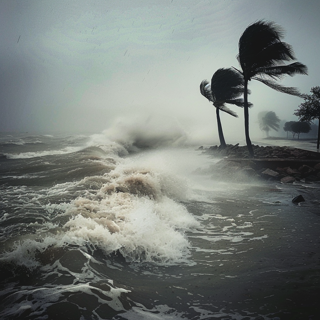
- At 4:00 A.M. Central Daylight Time (09:00 Coordinated Universal Time), the center of Tropical Storm Francine was located near latitude 24.4 North, longitude 96.2 West.
- Francine is moving toward the north-northwest near 5 Miles Per Hour (7 Kilometers Per Hour).
- A slow north-northwest motion is expected through this morning, followed by a turn to the northeast with an increase in forward speed.
- On the forecast track, Francine is anticipated to be just offshore of the coasts of northeastern Mexico and southern Texas through today, and make landfall in Louisiana on Wednesday.
- Maximum sustained winds are near 65 Miles Per Hour (100 Kilometers Per Hour) with higher gusts.
- Francine will likely become a hurricane today, with significant strengthening expected before it reaches the coast.
- Tropical-storm-force winds extend outward up to 140 miles (220 Kilometers) from the center.
- The estimated minimum central pressure is 992 mb (29.30 inches).
HAZARDS AFFECTING LAND
Key messages for Tropical Storm Francine can be found in the Tropical Cyclone Discussion under AWIPS header MIATCDAT1 and WMO header WTNT41 KNHC.
WIND:
- Hurricane conditions are expected within the hurricane warning area on Wednesday.
- Hurricane conditions are possible in the hurricane watch area on Wednesday, with tropical storm conditions expected by Wednesday morning within the warning areas.
- Tropical storm conditions are expected in the warning area in Mexico and south Texas through this afternoon.
- Tropical storm conditions are possible within the watch area along the northeastern coast of Mexico for the next several hours.
- Tropical storm conditions are also possible along portions of the Texas coast in the watch area today and tonight, and are possible in the watch area in eastern Louisiana on Wednesday.
RAINFALL:
- Francine is expected to bring storm total rainfall of 4 to 8 inches, with local amounts to 12 inches across much of Louisiana and Mississippi through Friday morning.
- This rainfall could lead to considerable flash and urban flooding.
- For a complete depiction of forecast rainfall associated with Francine, please see the National Weather Service Storm Total Rainfall Graphic, available at
hurricanes.gov/graphics_at1.shtml?rainqpf
- and the Flash Flood Risk graphic at
hurricanes.gov/graphics_at1.shtml?ero
STORM SURGE:
- The combination of a dangerous storm surge and the tide will cause normally dry areas near the coast to be flooded by rising waters moving inland from the shoreline.
- The water could reach the following heights above ground somewhere in the indicated areas if the peak surge occurs at the time of high tide
- Cameron, Louisianna to Port Fourchon, Louisianna 5 to 10 feet
- Vermilion Bay 5 to 10 feet
- Port Fourchon, Louisianna to Mouth of the Mississippi River, Louisianna 4 to 7 feet
- High Island, Texas to Cameron, Louisianna 3 to 5 feet
- Mouth of the Mississippi River, Louisianna to MS/AL Border 2 to 4 feet
- Lake Pontchartrain and Lake Maurepas 2 to 4 feet
- Mouth of the Rio Grande, Texas to High Island, Texas 1 to 3 feet
- Galveston Bay 1 to 3 feet
- MS/AL Border to AL/Florida Border 1 to 3 feet
- The deepest water will occur along the immediate coast near and to the east of the landfall location, where the surge will be accompanied by large and dangerous waves.
- Surge-related flooding depends on the relative timing of the surge and the tidal cycle, and can vary greatly over short distances.
- Storm surge is not expected to pose a threat to the risk reduction system levees.
- However, there may be some overtopping of local levees.
- For information specific to your area, please see products issued by your local National Weather Service forecast office.
- Minor coastal flooding is possible along the coast of Mexico in areas of onshore winds.
- For a complete depiction of areas at risk of storm surge inundation, please see the National Weather Service Peak Storm Surge Graphic, available at
hurricanes.gov/graphics_at1.shtml?peakSurge
TORNADOES:
- A few tornadoes are possible Wednesday morning through Wednesday night over near-coastal areas of Louisiana, Mississippi, Alabama, and the Florida Panhandle.
SURF:
- Swells generated by Francine are affecting portions of the coast of northeastern Mexico and southern Texas.
- These swells are expected to spread across the northwestern and northern Gulf of Mexico coastline during the next day or so.
- These swells are likely to cause life-threatening surf and rip current conditions.
- Please consult products from your local weather office.
NEXT ADVISORY
Next intermediate advisory at 7:00 A.M. Central Daylight Time.
Next complete advisory at 10:00 A.M. Central Daylight Time.
$$
Forecaster Pasch
Originally Posted at:
NATIONAL HURRICANE CENTER and CENTRAL PACIFIC HURRICANE CENTER
At The NATIONAL OCEANIC AND ATMOSPHERIC ADMINISTRATION
Stay Updated with news.freeptomaineradio.com’s Daily Newsletter
Stay informed! Subscribe to our daily newsletter to receive updates on our latest blog posts directly in your inbox. Don’t let important information get buried by big tech.
Current subscribers:


