


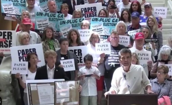
“Georgia Owes President Donald Trump an Apology” – Fulton County to Address Voter Fraud Issues in 2020 Election in Wednesday Special Hearing
by Jim Hoft, The Gateway Pundit:
“Georgia owes President Trump an Apology” says election integrity expert Joe Rossi in Fulton County.
More evidence came out recently summarizing the corruption and fraud in the 2020 Election in Georgia.
A hearing will take place this morning in Georgia to discuss the corrupt acts that occurred in Fulton County in the 2020 Election.
TRUTH LIVES on at https://sgtreport.tv/
🚨🚨IMPORTANT🚨🚨
GA State Election Board will discuss SEB2023-025 this morning
17,852 votes counted with no ballot images
20,713 original votes from tabulators out of thin air
3,930 duplicates counted and inserted via intentional human intervention.
a.k.a. FRAUD pic.twitter.com/gh1VtL9VBr
— Liz Harrington (@realLizUSA) August 7, 2024
“Georgia owes President Trump an apology”—Joe Rossi discusses the fraud uncovered in Fulton County during the 2020 Election. Instead of apologizing, the corrupt politicians in Georgia are covering up their crimes and working with the corrupt DA Fani Willis to indict President Trump for claiming that the election in the state was stolen.
Read More @ TheGatewayPundit.com
Originally Posted at https://www.sgtreport.com
Stay Updated with news.freeptomaineradio.com’s Daily Newsletter
Stay informed! Subscribe to our daily newsletter to receive updates on our latest blog posts directly in your inbox. Don’t let important information get buried by big tech.
Current subscribers:
2024 Echoes ‘1984’ | ZeroHedge
Authored by Victor Joecks via American Greatness,
The book “1984” is supposed to be a warning. Today’s leftists are using it as an instruction manual…
George Orwell’s classic novel is set in a dystopian world where Big Brother controls the population through information control and surveillance. See if any of this sounds familiar.
“Doublethink means the power of holding two contradictory beliefs in one’s mind simultaneously, and accepting both of them.”
During her career, especially when running for president in 2020, Kamala Harris took a number of radical positions. She praised efforts to defund the police. She once insinuated that Immigration and Customs Enforcement was comparable to the KKK and suggested the agency should be rebuilt “from scratch.” She wanted to decriminalize border crossings. She co-sponsored the Green New Deal. She supported a mandatory gun buyback program, eliminating private insurance and reparations. She was in favor of banning fracking and plastic straws.
Those policies play great in San Francisco, but not in battleground states. Not to worry. She’s flip-flopped on at least five major policy positions since becoming the presumptive nominee.
Instead of exposing this duplicity, the national mainstream media is participating in it.
“Harris is calibrating her policy pitch for going to battle with Trump,” the Associated Press wrote about her reversals.
“If the Party could thrust its hand into the past and say of this or that event, it never happened — that, surely, was more terrifying than mere torture and death.”
The attempted assassination of Donald Trump happened just over three weeks ago. The iconic photo of a bloodied Trump defiantly standing and pumping his fist went viral. Outside of conservative sites and social media accounts, it’s barely been seen since. The national media has largely moved on, eager to fluff up Harris.
Less than two weeks ago, pro-Hamas rioters stormed Washington, D.C., to protest Israeli Prime Minister Benjamin Netanyahu speaking to Congress. They tore down U.S. flags outside of Union Station and raised Palestinian flags. They burned an American flag, vandalized monuments and assaulted park police. Charges against some of the few people arrested have already been dropped.
An easy prediction: You’ll hear less about these two stories than Trump’s out-of-context “bloodbath” remark and Jan. 6. It’s like events that would make Trump look heroic and hurt the left never happened.
“Every record has been destroyed or falsified, every book rewritten …”
You can see this happening in real time. Last week, I googled “Trump rally.” The top result was “Kamala Harris rally in Atlanta.” The same thing happened to Elon Musk and many others.
Recently, Meta AI refused to acknowledge that Trump was almost assassinated. Meta is the parent company of Facebook. It inaccurately labeled a fist-pumping photo of a bloodied Trump as “altered.” When people used Google to search for information on Trump’s attempted assassination, its auto-fill wouldn’t even suggest his name.
Both companies claim they weren’t trying to rig search results. Those excuses would be more believable if almost all mistakes like these didn’t go in the same direction.
“Don’t you see that the whole aim of Newspeak is to narrow the range of thought? In the end, we shall make thoughtcrime literally impossible, because there will be no words in which to express it.”
Illegal aliens are merely undocumented migrants. Men who claim to be women are women. People voting for Donald Trump are a threat to democracy. Ramming scissors into the skull of an 8-month-old preborn baby and sucking her brains out is health care. Israel is the oppressor for defending itself against genocidal terrorists. Diversity requires ideological conformity.
2024 looks a lot like “1984,” but you get to help write the ending. Choose wisely.
Loading…
Originally Posted at; https://www.zerohedge.com//
Stay Updated with news.freeptomaineradio.com’s Daily Newsletter
Stay informed! Subscribe to our daily newsletter to receive updates on our latest blog posts directly in your inbox. Don’t let important information get buried by big tech.
Current subscribers:

Exclusive — Trump Tells Breitbart He’ll Solve Ukraine-Russia War ‘Before I Get to the White House, After I’m President-Elect’
PALM BEACH, Florida — Former President Donald Trump told Breitbart News exclusively on Thursday evening that he intends to negotiate peace between Russia and Ukraine as President-elect before he even is sworn in as the next president of the United States.
Trump, in an hourlong interview with Breitbart News at his luxurious seaside resort and club, Mar-a-Lago, here in South Florida, said that he wants to see the war between Russia and Ukraine “settled.”
“I want to see it settled,” Trump said. “I want to get it done.”
Trump said he knows Russian president Vladimir Putin and Ukrainian president Volodymyr Zelensky, and believes he can negotiate peace to end the “death” and “destruction” if elected again on Nov. 5.
“I know both heads of the countries,” Trump said. “I know President Putin very well. I want to see the death stopping. There’s death and there’s destruction. They are destroying the whole fabric of a certain part of the world. I want to get it negotiated, and get it done.”
Republican presidential nominee former President Donald Trump speaks to reporters during a news conference at his Mar-a-Lago estate Thursday, Aug. 8, 2024, in Palm Beach, Fla. (AP Photo/Alex Brandon)
Trump said his Democrat opponent, Vice President Kamala Harris, would keep the war going and keep flowing hundreds of billions of American tax dollars into Ukraine rather than ending it. He said Harris would do nothing, and because of her inaction “millions of people will die” if she were to win the election in November. He also said Harris’s ineptitude could drag the world into a global war.
“I don’t think she has any clue,” Trump said. “She wouldn’t handle it at all. I don’t think she’d do anything. I think it would just go on and millions of people will die. It could evolve into a World War also. She’s got no capability to get it done. I want to get it done. I’ve always had a very good relationship with both men and I think I’m in a very good position. It would have been easier to get done—it would have never started. If I were there, it would have never started.”
Trump also said he hopes he will be able to negotiate the peace deal ending the war in the timeframe between the Nov. 5 election and the Jan. 20, 2025, inauguration, should he win.
“You look at the heritage of the country—the cities are mostly knocked down,” Trump said, describing Ukraine. “They’re flattened. They’re just totally flattened. Have you ever seen some of these cities? There’s not a building standing. The country has been devastated. So I want to get it solved and I will be able to get it solved. And I’d like to do it before I get to the White House after I’m president-elect.”
Much more from Trump’s latest interview with Breitbart News is coming soon.
Originally Posted At www.breitbart.com
Stay Updated with news.freeptomaineradio.com’s Daily Newsletter
Stay informed! Subscribe to our daily newsletter to receive updates on our latest blog posts directly in your inbox. Don’t let important information get buried by big tech.
Current subscribers:
Post-Tropical Cyclone Emilia Forecast Discussion
344
WTPZ45 KNHC 090244
TCDEP5

Post-Tropical Cyclone Emilia Discussion Number  19
NWS National Hurricane Center Miami FL       EP052024
800 PM PDT Thu Aug 08 2024

Emilia has failed to produce much in the way of organized convection
since the prior burst waned earlier this morning, aside from a small
patch of -50 C cloud tops currently south of the estimated center.
SAB Dvorak classifications have been too weak to classify since this
afternoon, while the TAFB Final-T number is down to 2.0/30-kt which
was constrained from going lower. While there might continue to be
some occasional puffs of convection with Emilia over the next day or
so, the cyclone has crossed the 24 C isotherm and heading towards
even cooler ocean waters, and the chance of a more significant
convective resurgence is low. Thus, Emilia is being declared a 30-kt
post-tropical remnant low this cycle, and this will be the last NHC
advisory.

The system continues to move generally west-northwestward at 290/10
kt. This motion should continue for the next several days followed
by a turn more westward beyond 36 h as the low continues to weaken
and becomes more steered by the low-level trade wind flow. The NHC
track forecast is largely an update of the previous forecast, in
good agreement with the multi-model consensus aids. The latest
forecast now shows the remnant low dissipating after 72 h, a bit
faster than before.


FORECAST POSITIONS AND MAX WINDS

INIT  09/0300Z 22.3N 125.3W   30 KT  35 MPH...POST-TROP/REMNT LOW
 12H  09/1200Z 22.9N 127.0W   30 KT  35 MPH...POST-TROP/REMNT LOW
 24H  10/0000Z 23.5N 129.0W   25 KT  30 MPH...POST-TROP/REMNT LOW
 36H  10/1200Z 24.1N 131.0W   25 KT  30 MPH...POST-TROP/REMNT LOW
 48H  11/0000Z 24.6N 132.7W   20 KT  25 MPH...POST-TROP/REMNT LOW
 60H  11/1200Z 24.8N 134.5W   20 KT  25 MPH...POST-TROP/REMNT LOW
 72H  12/0000Z 24.7N 136.6W   20 KT  25 MPH...POST-TROP/REMNT LOW
 96H  13/0000Z...DISSIPATED

$$
Forecaster Papin
Originally Posted at:
NATIONAL HURRICANE CENTER and CENTRAL PACIFIC HURRICANE CENTER At The NATIONAL OCEANIC AND ATMOSPHERIC ADMINISTRATION
Stay Updated with news.freeptomaineradio.com’s Daily Newsletter
Stay informed! Subscribe to our daily newsletter to receive updates on our latest blog posts directly in your inbox. Don’t let important information get buried by big tech.
Current subscribers:
Post-Tropical Cyclone Emilia Wind Speed Probabilities
000
FOPZ15 KNHC 090242
PWSEP5

POST-TROPICAL CYCLONE EMILIA WIND SPEED PROBABILITIES NUMBER  19
NWS NATIONAL HURRICANE CENTER MIAMI FL       EP052024
0300 UTC FRI AUG 09 2024

AT 0300Z THE CENTER OF POST-TROPICAL CYCLONE EMILIA WAS LOCATED NEAR
LATITUDE 22.3 NORTH...LONGITUDE 125.3 WEST WITH MAXIMUM SUSTAINED
WINDS NEAR 30 KTS...35 MPH...55 KM/H.

Z INDICATES COORDINATED UNIVERSAL TIME (GREENWICH)
   PACIFIC  DAYLIGHT TIME (PDT)...SUBTRACT 7 HOURS FROM Z TIME
   HAWAIIAN STANDARD TIME (HST)...SUBTRACT 10 HOURS FROM Z TIME

WIND SPEED PROBABILITY TABLE FOR SPECIFIC LOCATIONS

CHANCES OF SUSTAINED (1-MINUTE AVERAGE) WIND SPEEDS OF AT LEAST
   ...34 KT (39 MPH... 63 KM/H)...
   ...50 KT (58 MPH... 93 KM/H)...
   ...64 KT (74 MPH...119 KM/H)...
FOR LOCATIONS AND TIME PERIODS DURING THE NEXT 5 DAYS

PROBABILITIES FOR LOCATIONS ARE GIVEN AS OP(CP) WHERE
    OP  IS THE PROBABILITY OF THE EVENT BEGINNING DURING
        AN INDIVIDUAL TIME PERIOD (ONSET PROBABILITY)
   (CP) IS THE PROBABILITY OF THE EVENT OCCURRING BETWEEN
        00Z FRI AND THE FORECAST HOUR (CUMULATIVE PROBABILITY)

PROBABILITIES ARE GIVEN IN PERCENT
X INDICATES PROBABILITIES LESS THAN 1 PERCENT
PROBABILITIES FOR 34 KT AND 50 KT ARE SHOWN AT A GIVEN LOCATION WHEN
THE 5-DAY CUMULATIVE PROBABILITY IS AT LEAST 3 PERCENT.
PROBABILITIES FOR 34...50...64 KT SHOWN WHEN THE 5-DAY
64-KT CUMULATIVE PROBABILITY IS AT LEAST 1 PERCENT.


  - - - - WIND SPEED PROBABILITIES FOR SELECTED LOCATIONS - - - -

               FROM    FROM    FROM    FROM    FROM    FROM    FROM
  TIME       00Z FRI 12Z FRI 00Z SAT 12Z SAT 00Z SUN 00Z MON 00Z TUE
PERIODS         TO      TO      TO      TO      TO      TO      TO
             12Z FRI 00Z SAT 12Z SAT 00Z SUN 00Z MON 00Z TUE 00Z WED

FORECAST HOUR    (12)   (24)    (36)    (48)    (72)    (96)   (120)
- - - - - - - - - - - - - - - - - - - - - - - - - - - - - - - - - -
LOCATION       KT

25N 130W       34  X   2( 2)   3( 5)   X( 5)   X( 5)   X( 5)   X( 5)

25N 135W       34  X   X( X)   X( X)   1( 1)   5( 6)   X( 6)   X( 6)

$$
FORECASTER PAPIN
Originally Posted at:
NATIONAL HURRICANE CENTER and CENTRAL PACIFIC HURRICANE CENTER At The NATIONAL OCEANIC AND ATMOSPHERIC ADMINISTRATION
Stay Updated with news.freeptomaineradio.com’s Daily Newsletter
Stay informed! Subscribe to our daily newsletter to receive updates on our latest blog posts directly in your inbox. Don’t let important information get buried by big tech.
Current subscribers:

POST-TROPICAL CYCLONE EMILIA
POST-TROPICAL CYCLONE EMILIA
Coastal Watches/Warnings and Forecast Cone for Storm Center
* If the storm is forecast to dissipate within 3 days, the “Full Forecast” and “3 day” graphic will be identical
Click Here for a 5-day Cone Printer Friendly Graphic
How to use the cone graphic (video):

About this product:
This graphic shows an approximate representation of coastal areas under a hurricane warning (red), hurricane watch (pink),
tropical storm warning (blue) and tropical storm watch (yellow). The orange circle indicates the current position of the
center of the tropical cyclone. The black line, when selected, and dots show the National Hurricane Center (NHC) forecast track of the center
at the times indicated. The dot indicating the forecast center location will be black if the cyclone is forecast to be
tropical and will be white with a black outline if the cyclone is forecast to be extratropical. If only an L is displayed,
then the system is forecast to be a remnant low. The letter inside the dot indicates the NHC’s forecast intensity for that time:
D: Tropical Depression – wind speed less than 39 MPH
S: Tropical Storm – wind speed between 39 MPH and 73 MPH
H: Hurricane – wind speed between 74 MPH and 110 MPH
M: Major Hurricane – wind speed greater than 110 MPH
NHC tropical cyclone forecast tracks can be in error. This forecast
uncertainty is conveyed by the track forecast “cone”, the solid white
and stippled white areas in the graphic. The solid white area depicts
the track forecast uncertainty for days 1-3 of the forecast, while the
stippled area depicts the uncertainty on days 4-5. Historical data
indicate that the entire 5-day path of the center of the tropical
cyclone will remain within the cone about 60-70% of the time. To
form the cone, a set of imaginary circles are placed along the
forecast track at the 12, 24, 36, 48, 72, 96, and 120 h positions,
where the size of each circle is set so that it encloses 67% of the
previous five years official forecast errors. The cone is then formed
by smoothly connecting the area swept out by the set of circles.
It is also important to realize that a tropical cyclone is not a point. Their
effects can span many hundreds of miles from the center. The area
experiencing hurricane force (one-minute average wind speeds of at least
74 mph) and tropical storm force (one-minute average wind speeds of
39-73 mph) winds can extend well beyond the white areas shown enclosing
the most likely track area of the center. The distribution of hurricane
and tropical storm force winds in this tropical cyclone can be seen in
the Wind History graphic linked above.
Considering the combined forecast uncertainties in track, intensity, and size, the
chances that any particular location will experience winds of 34 kt (tropical storm force),
50 kt, or 64 kt (hurricane force) from this tropical cyclone are presented in
tabular form for selected locations and forecast positions. This information is also presented in
graphical form for the 34 kt, 50 kt,
and 64 kt thresholds.
Note: A detailed definition of the NHC track forecast cone is also available.
Originally Posted at:
NATIONAL HURRICANE CENTER and CENTRAL PACIFIC HURRICANE CENTER
At The NATIONAL OCEANIC AND ATMOSPHERIC ADMINISTRATION
Stay Updated with news.freeptomaineradio.com’s Daily Newsletter
Stay informed! Subscribe to our daily newsletter to receive updates on our latest blog posts directly in your inbox. Don’t let important information get buried by big tech.
Current subscribers:
Tropical Depression Debby Public Advisory
723
WTNT34 KWNH 090242
TCPAT4

BULLETIN
Tropical Depression Debby Advisory Number  27
NWS Weather Prediction Center College Park MD   AL042024
1100 PM EDT Thu Aug 08 2024

...MAJOR FLOOD THREAT CONTINUES FOR PORTIONS OF WESTERN VIRGINIA...


SUMMARY OF 1100 PM EDT...0300 UTC...INFORMATION
-----------------------------------------------
LOCATION...36.2N 80.2W
ABOUT 80 MI...135 KM NNE OF CHARLOTTE NORTH CAROLINA
ABOUT 90 MI...140 KM WNW OF RALEIGH NORTH CAROLINA
MAXIMUM SUSTAINED WINDS...30 MPH...45 KM/H
PRESENT MOVEMENT...NNE OR 20 DEGREES AT 26 MPH...43 KM/H
MINIMUM CENTRAL PRESSURE...1001 MB...29.56 INCHES


WATCHES AND WARNINGS
--------------------
SUMMARY OF WATCHES AND WARNINGS IN EFFECT:

Flood Watches and Warnings are in effect for portions of....
* South Carolina
* North Carolina
* Virginia
* Eastern West Virginia
* Maryland
* Pennsylvania

A Flood Watch is in effect for portions of...
* Upstate New York
* Northern Vermont
* Northern New Hampshire

A Tornado Watch is in effect for portions of...
* Eastern North Carolina
* Northern and Eastern Virginia
* Maryland
* District of Columbia
* Eastern West Virginia

Coastal Flood Advisories are in effect for portions of...
* Eastern North Carolina
* Areas surrounding the Chesapeake Bay and Potomac River
* Central New Jersey Coast

A Gale Watch is in effect the coastal waters of...
* Rhode Island
* Southeastern Massachusetts up through Cape Cod

Wind Advisories are in effect for portions of...
* Western Virginia
* Eastern Maryland
* Delaware
* Eastern Pennsylvania
* New Jersey
* Southern New York
* Southern Connecticut


DISCUSSION AND OUTLOOK
----------------------
At 1100 PM EDT (0300 UTC), the center of Tropical Depression Debby
was located near latitude 36.2 North, longitude 80.2 West. The
depression is moving toward the north-northeast near 26 mph (43
km/h) and this motion is expected to slowly increase and shift to
the northeast over the next day.

Maximum sustained winds are near 30 mph (45 km/h) with higher gusts.
Little change in strength is forecast during the next 48 hours.

The estimated minimum central pressure is 1001 mb (29.56 inches).


HAZARDS AFFECTING LAND
----------------------
Key messages for Debby can be found in the Tropical Cyclone
Discussion under AWIPS header MIATCDAT4 and WMO header WTNT44 KNHC.

RAINFALL: Debby is expected to produce an additional 3 to 6 inches
of rainfall with locally higher amounts, across portions of
southeastern North Carolina leading to maximum storm total amounts
as high as 15 inches.  Additional rainfall of 1 to 3 inches over
portions of eastern South Carolina will bring maximum storm total
amounts as high as 20 to 25 inches. Considerable flooding is
expected across portions of eastern South Carolina and southeast
North Carolina through Friday.

From central North Carolina northward across portions of Virginia, 3
to 7 inches with local amounts to 10 inches, are expected through
Friday. This rainfall will likely result in areas of considerable to
locally catastrophic flash and urban flooding, especially in the
terrain of western Virginia, with river flooding also possible.

From portions of Maryland north through Upstate New York and
Vermont, 2 to 4 inches, with local amounts to 6 inches, are expected
through Friday night. This will likely result in areas of
considerable flash and urban flooding as well as river flooding.

For the remainder of northern New England, 1 to 3 inches, with
local amounts to 4 inches, are expected into Saturday.  Scattered
instances of flash flooding are possible.

For a complete depiction of forecast rainfall and flash flooding
associated with  Debby, please see the National Weather Service
Storm Total Rainfall Graphic, available at
hurricanes.gov/graphics_at4.shtml?rainqpf and the Flash Flood Risk
graphic at hurricanes.gov/graphics_at4.shtml?ero.  For a list of
rainfall observations (and wind reports) associated this storm, see
the companion storm summary at WBCSCCNS4 with the WMO header ACUS44
KWBC or at the following link:
www.wpc.ncep.noaa.gov/discussions/nfdscc4.html.

TORNADOES: A few tornadoes may occur tonight from eastern North
Carolina into Virginia and Maryland. The threat for tornadoes will
shift northward into parts of New Jersey, eastern Pennsylvania and
southeast New York on Friday.

SURF:  Large swells will continue to affect the Southeast and the
Mid Atlantic coast for another day or so. These conditions are
likely to cause life-threatening surf and rip current conditions.
Please consult products from your local weather office.


NEXT ADVISORY
-------------
Next complete advisory at 500 AM EDT.

$$
Forecaster Pereira/Gallina/Chenard
Originally Posted at:
NATIONAL HURRICANE CENTER and CENTRAL PACIFIC HURRICANE CENTER
At The NATIONAL OCEANIC AND ATMOSPHERIC ADMINISTRATION
Stay Updated with news.freeptomaineradio.com’s Daily Newsletter
Stay informed! Subscribe to our daily newsletter to receive updates on our latest blog posts directly in your inbox. Don’t let important information get buried by big tech.
Current subscribers:
Tropical Depression Debby Public Advisory
000
WTNT34 KNHC 082031
TCPAT4

BULLETIN
Tropical Depression Debby Advisory Number  26
NWS National Hurricane Center Miami FL       AL042024
500 PM EDT Thu Aug 08 2024

...MAJOR FLOOD THREAT CONTINUES FOR PORTIONS OF THE CAROLINAS AND
WESTERN VIRGINIA...
...FUTURE ADVISORIES WILL BE ISSUED BY THE WEATHER PREDICTION
CENTER...


SUMMARY OF 500 PM EDT...2100 UTC...INFORMATION
----------------------------------------------
LOCATION...35.1N 80.2W
ABOUT 45 MI...75 KM E OF CHARLOTTE NORTH CAROLINA
ABOUT 95 MI...155 KM WSW OF RALEIGH NORTH CAROLINA
MAXIMUM SUSTAINED WINDS...35 MPH...55 KM/H
PRESENT MOVEMENT...NNW OR 345 DEGREES AT 10 MPH...17 KM/H
MINIMUM CENTRAL PRESSURE...998 MB...29.47 INCHES


WATCHES AND WARNINGS
--------------------
CHANGES WITH THIS ADVISORY:

All Tropical Storm Warnings have been discontinued.

SUMMARY OF WATCHES AND WARNINGS IN EFFECT:

There are no coastal watches or warnings in effect.


DISCUSSION AND OUTLOOK
----------------------
At 500 PM EDT (2100 UTC), the center of Tropical Depression Debby
was located inland near latitude 35.1 North, longitude 80.2 West.
The depression is moving toward the north-northwest near 10 mph (17
km/h).  A faster northward or north-northeastward motion is
expected during the next day or two.

Maximum sustained winds are near 35 mph (55 km/h) with higher gusts.
Little change in strength is forecast during the next couple of
days, but Debby is expected to become a post-tropical cyclone on
Friday.

The estimated minimum central pressure based on surface
observations is 998 mb (29.47 inches).


HAZARDS AFFECTING LAND
----------------------
Key messages for Debby can be found in the Tropical Cyclone
Discussion under AWIPS header MIATCDAT4 and WMO header WTNT44 KNHC.

WIND: Wind gusts to tropical-storm-force could occur for a few more
hours along portions of the North Carolina coast.

STORM SURGE: Coastal flooding is possible in the Cape Fear, Neuse,
and Pamlico Rivers...1 to 3 ft.

For a complete depiction of areas at risk of storm surge inundation,
please see the National Weather Service Peak Storm Surge Graphic,
available at hurricanes.gov/graphics_at4.shtml?peakSurge.

RAINFALL: Debby is expected to produce an additional 3 to 6 inches
of rainfall with locally higher amounts, across portions of
southeastern North Carolina leading to maximum storm total amounts
as high as 15 inches.  Additional rainfall of 1 to 3 inches over
portions of eastern South Carolina will bring maximum storm total
amounts as high as 20 to 25 inches. Considerable flooding is
expected across portions of eastern South Carolina and southeast
North Carolina through Friday.

From central North Carolina northward across portions of Virginia, 3
to 7 inches with local amounts to 10 inches, are expected through
Friday. This rainfall will likely result in areas of considerable to
locally catastrophic flash and urban flooding, especially in the
terrain of western Virginia, with river flooding also possible.

From portions of Maryland north through Upstate New York and
Vermont, 2 to 4 inches, with local amounts to 6 inches, are expected
through Friday night. This will likely result in areas of
considerable flash and urban flooding as well as river flooding.

For the remainder of northern New England, 1 to 3 inches, with
local amounts to 4 inches, are expected into Saturday.  Scattered
instances of flash flooding are possible.

For a complete depiction of forecast rainfall and flash flooding
associated with  Debby, please see the National Weather Service
Storm Total Rainfall Graphic, available at
hurricanes.gov/graphics_at4.shtml?rainqpf and the Flash Flood Risk
graphic at hurricanes.gov/graphics_at4.shtml?ero.  For a list of
rainfall observations (and wind reports) associated this storm, see
the companion storm summary at WBCSCCNS4 with the WMO header ACUS44
KWBC or at the following link:
www.wpc.ncep.noaa.gov/discussions/nfdscc4.html.

TORNADOES: A few tornadoes may occur through tonight from central
and eastern North Carolina into central and southeast Virginia.
The threat for tornadoes will shift northward into parts of New
Jersey and eastern Pennsylvania on Friday.

SURF:  Large swells will continue to affect the Southeast U.S.
coast for another day or so. These conditions are likely to
cause life-threatening surf and rip current conditions. Please
consult products from your local weather office.


NEXT ADVISORY
-------------
This is the last public advisory issued by the National Hurricane
Center on Debby.  Future information on this system can be
found in Public Advisories issued by the Weather Prediction Center
beginning at 1100 PM EDT, under AWIPS header TCPAT4, WMO
header WTNT34 KWNH, and on the web at www.hurricanes.gov.

Rainfall forecasts for the United States can always be found at
https://www.wpc.ncep.noaa.gov/qpf/qpf2.shtml
and outlooks of flash flood risks can be found at
https://www.wpc.ncep.noaa.gov/qpf/excessive_rainfall_outlook_ero.php
.

$$
Forecaster Cangialosi
Originally Posted at:
NATIONAL HURRICANE CENTER and CENTRAL PACIFIC HURRICANE CENTER
At The NATIONAL OCEANIC AND ATMOSPHERIC ADMINISTRATION
Stay Updated with news.freeptomaineradio.com’s Daily Newsletter
Stay informed! Subscribe to our daily newsletter to receive updates on our latest blog posts directly in your inbox. Don’t let important information get buried by big tech.
Current subscribers:
Post-Tropical Cyclone Emilia Public Advisory
000
WTPZ35 KNHC 090241
TCPEP5

BULLETIN
Post-Tropical Cyclone Emilia Advisory Number  19
NWS National Hurricane Center Miami FL       EP052024
800 PM PDT Thu Aug 08 2024

...EMILIA BECOMES A REMNANT LOW...
...THIS IS THE FINAL NHC ADVISORY...


SUMMARY OF 800 PM PDT...0300 UTC...INFORMATION
----------------------------------------------
LOCATION...22.3N 125.3W
ABOUT 980 MI...1580 KM W OF THE SOUTHERN TIP OF BAJA CALIFORNIA
MAXIMUM SUSTAINED WINDS...35 MPH...55 KM/H
PRESENT MOVEMENT...WNW OR 290 DEGREES AT 12 MPH...19 KM/H
MINIMUM CENTRAL PRESSURE...1004 MB...29.65 INCHES


WATCHES AND WARNINGS
--------------------
There are no coastal watches or warnings in effect.


DISCUSSION AND OUTLOOK
----------------------
At 800 PM PDT (0300 UTC), the center of Post-Tropical Cyclone Emilia
was located near latitude 22.3 North, longitude 125.3 West. The
post-tropical cyclone is moving toward the west-northwest near 12
mph (19 km/h) and this general motion with a decrease in forward
speed and turn westward is expected over the next couple of days.

Maximum sustained winds are near 35 mph (55 km/h) with higher gusts.
Additional weakening is forecast, and the post-tropical remnant low
is expected to dissipate by the end of this weekend.

The estimated minimum central pressure is 1004 mb (29.65 inches).


HAZARDS AFFECTING LAND
----------------------
None


NEXT ADVISORY
-------------
This is the last public advisory issued by the National Hurricane
Center on this system. For additional information on the remnant low
please see High Seas Forecasts issued by the National Weather
Service, under AWIPS header NFDHSFEPI, WMO header FZPN02 KWBC, and
on the web at ocean.weather.gov/shtml/NFDHSFEPI.php


$$
Forecaster Papin
Originally Posted at:
NATIONAL HURRICANE CENTER and CENTRAL PACIFIC HURRICANE CENTER
At The NATIONAL OCEANIC AND ATMOSPHERIC ADMINISTRATION
Stay Updated with news.freeptomaineradio.com’s Daily Newsletter
Stay informed! Subscribe to our daily newsletter to receive updates on our latest blog posts directly in your inbox. Don’t let important information get buried by big tech.
Current subscribers:
Post-Tropical Cyclone Emilia Forecast Advisory
769
WTPZ25 KNHC 090240
TCMEP5

POST-TROPICAL CYCLONE EMILIA FORECAST/ADVISORY NUMBER  19
NWS NATIONAL HURRICANE CENTER MIAMI FL       EP052024
0300 UTC FRI AUG 09 2024

POST-TROPICAL CYCLONE CENTER LOCATED NEAR 22.3N 125.3W AT 09/0300Z
POSITION ACCURATE WITHIN  30 NM

PRESENT MOVEMENT TOWARD THE WEST-NORTHWEST OR 290 DEGREES AT  10 KT

ESTIMATED MINIMUM CENTRAL PRESSURE 1004 MB
MAX SUSTAINED WINDS  30 KT WITH GUSTS TO  40 KT.
12 FT SEAS..180NE   0SE  60SW  90NW.
WINDS AND SEAS VARY GREATLY IN EACH QUADRANT.  RADII IN NAUTICAL
MILES ARE THE LARGEST RADII EXPECTED ANYWHERE IN THAT QUADRANT.

REPEAT...CENTER LOCATED NEAR 22.3N 125.3W AT 09/0300Z
AT 09/0000Z CENTER WAS LOCATED NEAR 22.1N 124.8W

FORECAST VALID 09/1200Z 22.9N 127.0W...POST-TROP/REMNT LOW
MAX WIND  30 KT...GUSTS  40 KT.

FORECAST VALID 10/0000Z 23.5N 129.0W...POST-TROP/REMNT LOW
MAX WIND  25 KT...GUSTS  35 KT.

FORECAST VALID 10/1200Z 24.1N 131.0W...POST-TROP/REMNT LOW
MAX WIND  25 KT...GUSTS  35 KT.

FORECAST VALID 11/0000Z 24.6N 132.7W...POST-TROP/REMNT LOW
MAX WIND  20 KT...GUSTS  30 KT.

FORECAST VALID 11/1200Z 24.8N 134.5W...POST-TROP/REMNT LOW
MAX WIND  20 KT...GUSTS  30 KT.

FORECAST VALID 12/0000Z 24.7N 136.6W...POST-TROP/REMNT LOW
MAX WIND  20 KT...GUSTS  30 KT.

EXTENDED OUTLOOK. NOTE...ERRORS FOR TRACK HAVE AVERAGED NEAR 100 NM
ON DAY 4 AND 125 NM ON DAY 5...AND FOR INTENSITY NEAR 15 KT EACH DAY

OUTLOOK VALID 13/0000Z...DISSIPATED

REQUEST FOR 3 HOURLY SHIP REPORTS WITHIN 300 MILES OF 22.3N 125.3W

THIS IS THE LAST FORECAST/ADVISORY ISSUED BY THE NATIONAL HURRICANE
CENTER ON THIS SYSTEM. FOR ADDITIONAL INFORMATION ON THE REMNANT LOW
PLEASE SEE HIGH SEAS FORECASTS ISSUED BY THE NATIONAL WEATHER
SERVICE...UNDER AWIPS HEADER NFDHSFEPI AND WMO HEADER FZPN02 KWBC.


$$
FORECASTER PAPIN
Originally Posted at:
NATIONAL HURRICANE CENTER and CENTRAL PACIFIC HURRICANE CENTER At The NATIONAL OCEANIC AND ATMOSPHERIC ADMINISTRATION
Stay Updated with news.freeptomaineradio.com’s Daily Newsletter
Stay informed! Subscribe to our daily newsletter to receive updates on our latest blog posts directly in your inbox. Don’t let important information get buried by big tech.
Current subscribers: