


Tropical Storm Ernesto Forecast Discussion
000
WTNT45 KNHC 130832
TCDAT5

Tropical Storm Ernesto Discussion Number   7
NWS National Hurricane Center Miami FL       AL052024
500 AM AST Tue Aug 13 2024

Satellite imagery and French radar data from Guadeloupe indicate
that convection has become more concentrated near the center of
Ernesto during the past several hours, and there is increased
evidence of cyclonic rotation in the radar imagery.  However, this
has not yet resulted in significant intensification, with surface
obs from the Leeward Islands showing a large area of pressures near
1007-1009 mb and no evidence of any tight wind center.  Based on
this and the latest satellite intensity estimates, the initial
intensity is held at 35 kt.

The initial motion is a somewhat uncertain 280/17, a little slower
than before.  Ernesto should turn west-northwestward with an
additional decrease in forward speed during the next 12 h or so as
it approaches a developing break in the subtropical ridge.  This
motion should bring the center near or over the Leeward Islands
today and near or over the Virgin Islands and Puerto Rico tonight
and early Wednesday.  After that, the flow between the subtropical
ridge and a mid-latitude trough moving eastward from the United
States should cause the cyclone to turn northward and northeastward.
By the end of the forecast period, this trough is expected to move
eastward away from Ernesto, with a mid-latitude shortwave ridge
passing north of the storm.  This development should cause another
decrease in forward speed during the 96-120 h period.  The new
forecast track is close to the various consensus models, and it is
also similar to the previous forecast track.

Ernesto is forecast to be in an environment of light to moderate
shear and over warm sea surface temperatures through the forecast
period, and this combination should allow it to strengthen.
Intensification is likely to be slow during the first 12-24 h
primarily due to the current lack of organization.  After that, a
faster rate of strengthening is expected, with Ernesto forecast to
reach hurricane strength in 36-48 h.  The intensity forecast
follows the overall trend of the intensity guidance, and it lies
between the intensity consensus and the upper edge of the guidance.


Key Messages:

1. Ernesto is expected to bring tropical storm conditions to
portions of the Leeward Islands today and to the Virgin Islands and
Puerto Rico by late today or tonight. Tropical Storm Warnings are
in effect for this entire area.

2. Heavy rainfall may result in locally considerable flash flooding
and mudslides in areas of the Leeward Islands through today, and
over the Virgin Islands into Puerto Rico by later today through
Wednesday.

3. It is too soon to know what impacts Ernesto could bring to
Bermuda late this week, and interests there should monitor the
progress of this system.


FORECAST POSITIONS AND MAX WINDS

INIT  13/0900Z 16.2N  61.3W   35 KT  40 MPH
 12H  13/1800Z 17.1N  63.4W   40 KT  45 MPH
 24H  14/0600Z 18.7N  65.7W   50 KT  60 MPH
 36H  14/1800Z 20.7N  67.3W   60 KT  70 MPH
 48H  15/0600Z 23.0N  68.3W   70 KT  80 MPH
 60H  15/1800Z 25.1N  68.3W   80 KT  90 MPH
 72H  16/0600Z 27.2N  67.3W   90 KT 105 MPH
 96H  17/0600Z 30.5N  65.0W   95 KT 110 MPH
120H  18/0600Z 33.5N  64.5W   95 KT 110 MPH

$$
Forecaster Beven
Originally Posted at:
NATIONAL HURRICANE CENTER and CENTRAL PACIFIC HURRICANE CENTER
At The NATIONAL OCEANIC AND ATMOSPHERIC ADMINISTRATION
Stay Updated with news.freeptomaineradio.com’s Daily Newsletter
Stay informed! Subscribe to our daily newsletter to receive updates on our latest blog posts directly in your inbox. Don’t let important information get buried by big tech.
Current subscribers:
Tropical Storm Ernesto Public Advisory
000
WTNT35 KNHC 130831
TCPAT5
BULLETIN
Tropical Storm Ernesto Advisory Number 7
NATIONAL WEATHER SERVICE, National Hurricane Center Miami Florida AL052024
500 AM AST Tue Aug 13 2024
CENTER OF ERNESTO NEAR GUADELOUPE IN THE LEEWARD ISLANDS
SUMMARY OF 500 AM AST 09:00 COORDINATED UNIVERSAL TIME INFORMATION
LOCATION 16.2 NORTH 61.3 WEST
ABOUT 10 MILES, 15 KILOMETERS SOUTHEAST, OF GUADELOUPE
ABOUT 350 MILES, 565 KILOMETERS EAST SOUTHEAST OF SAN JUAN PUERTO RICO
MAXIMUM SUSTAINED WINDS 40 MILES PER HOUR, 65 KILOMETERS PER HOUR
PRESENT MOVEMENT WEST, OR 280 DEGREES AT 20 MILES PER HOUR, 31 KILOMETERS PER HOUR
MINIMUM CENTRAL PRESSURE 1007 MILLIBAR, 29.74 INCHES
WATCHES AND WARNINGS
CHANGES WITH THIS ADVISORY: None.
SUMMARY OF WATCHES AND WARNINGS IN EFFECT:
A Tropical Storm Warning is in effect for
- Saint Kitts, Nevis, Montserrat, Antigua, Barbuda, and Anguilla
- Guadeloupe
- Saint Martin and Saint Barthelemy
- Sint Maarten
- British Virgin Islands
- U.S. Virgin Islands
- Puerto Rico
- Vieques
- Culebra
- A Tropical Storm Warning means that tropical storm conditions are expected somewhere within the warning area within 36 hours.
- Interests elsewhere in the northeastern Caribbean should monitor the progress of Ernesto.
- For storm information specific to your area in the United States, including possible inland watches and warnings, please monitor products issued by your local National Weather Service forecast office.
- For storm information specific to your area outside of the United States, please monitor products issued by your national meteorological service.
DISCUSSION AND OUTLOOK
- At 500 AM AST (09:00 COORDINATED UNIVERSAL TIME), the center of Tropical Storm Ernesto was located near latitude 16.2 North, longitude 61.3 West.
- Ernesto is moving toward the west near 20 Miles Per Hour, (31 Kilometers Per Hour).
- A west northwestward motion with some decrease in forward speed is expected during the next day or so.
- On the forecast track, Ernesto is expected to move across portions of the Leeward Islands this morning and near or over the U.S. and British Virgin Islands and Puerto Rico by this evening.
- After passing Puerto Rico and the Virgin Islands, Ernesto is forecast to turn northward over the western Atlantic.
- Maximum sustained winds are near 40 Miles Per Hour, (65 Kilometers Per Hour) with higher gusts.
- Gradual strengthening is expected during the next few days, and Ernesto could reach hurricane strength by Thursday over the waters north of the Greater Antilles.
- Tropical storm force winds extend outward up to 70 miles (110 km) from the center.
- Saint Barthelemy recently reported a wind gust of 53 Miles Per Hour, (85 Kilometers Per Hour).
- The estimated minimum central pressure based on surface observations in the Leeward Islands is 1007 Millibar, (29.74 inches).
HAZARDS AFFECTING LAND
Key messages for Ernesto can be found in the Tropical Cyclone Discussion under AWIPS header MIATCDAT5 and WMO header WTNT45 KNHC and on the web at
hurricanes.gov/text/MIATCDAT5.shtml
RAINFALL:
- Tropical Storm Ernesto is expected to produce total rain accumulations of 4 to 6 inches over portions of the Leeward and Virgin Islands.
- For Puerto Rico, 3 to 6 inches of rainfall, with maximum amounts of 10 inches, is expected.
- For a complete depiction of forecast rainfall associated with Tropical Storm Ernesto, please see the National Weather Service Storm Total Rainfall Graphic, available at
hurricanes.gov/graphics_at5.shtml?rainqpf
- Elsewhere in the Caribbean, Tropical Storm Ernesto is expected to produce the following rain accumulations through Friday morning:
- Windward Islands… 1 to 4 inches
- Eastern Hispaniola… 2 to 4 inches
WIND:
- Tropical storm conditions are expected in the warning area for the Leeward Islands beginning during the next few hours.
- Tropical storm conditions are expected to begin spreading over the Virgin Islands and Puerto Rico by this evening.
STORM SURGE:
- A storm surge will raise water levels by as much as 1 to 3 feet above ground level for the eastern coast of Puerto Rico from San Juan to Guayama, including the islands of Culebra and Vieques and in the U.S. Virgin Islands, including Saint Thomas, St. John, and Saint Croix.
- A storm surge will raise water levels by as much as 1 to 3 feet above normal tide levels in the British Virgin Islands.
- Near the coast, the surge will be accompanied by large and destructive waves.
SURF:
- Swells generated by Ernesto will likely begin to affect portions of the Leeward Islands beginning in the next several hours.
- These swells are likely to cause life threatening surf and rip current conditions.
- Please consult products from your local weather office.
NEXT ADVISORY
Next intermediate advisory at 800 AM AST.
Next complete advisory at 1100 AM AST.
$$
Forecaster Beven
Originally Posted at:
NATIONAL HURRICANE CENTER and CENTRAL PACIFIC HURRICANE CENTER
At The NATIONAL OCEANIC AND ATMOSPHERIC ADMINISTRATION
Stay Updated with news.freeptomaineradio.com’s Daily Newsletter
Stay informed! Subscribe to our daily newsletter to receive updates on our latest blog posts directly in your inbox. Don’t let important information get buried by big tech.
Current subscribers:
Tropical Storm Ernesto Wind Speed Probabilities
000
FONT15 KNHC 130831
PWSAT5

TROPICAL STORM ERNESTO WIND SPEED PROBABILITIES NUMBER   7
NWS NATIONAL HURRICANE CENTER MIAMI FL       AL052024
0900 UTC TUE AUG 13 2024

AT 0900Z THE CENTER OF TROPICAL STORM ERNESTO WAS LOCATED NEAR
LATITUDE 16.2 NORTH...LONGITUDE 61.3 WEST WITH MAXIMUM SUSTAINED
WINDS NEAR 35 KTS...40 MPH...65 KM/H.

Z INDICATES COORDINATED UNIVERSAL TIME (GREENWICH)
   ATLANTIC STANDARD TIME (AST)...SUBTRACT 4 HOURS FROM Z TIME
   EASTERN  DAYLIGHT TIME (EDT)...SUBTRACT 4 HOURS FROM Z TIME
   CENTRAL  DAYLIGHT TIME (CDT)...SUBTRACT 5 HOURS FROM Z TIME

WIND SPEED PROBABILITY TABLE FOR SPECIFIC LOCATIONS

CHANCES OF SUSTAINED (1-MINUTE AVERAGE) WIND SPEEDS OF AT LEAST
   ...34 KT (39 MPH... 63 KM/H)...
   ...50 KT (58 MPH... 93 KM/H)...
   ...64 KT (74 MPH...119 KM/H)...
FOR LOCATIONS AND TIME PERIODS DURING THE NEXT 5 DAYS

PROBABILITIES FOR LOCATIONS ARE GIVEN AS OP(CP) WHERE
    OP  IS THE PROBABILITY OF THE EVENT BEGINNING DURING
        AN INDIVIDUAL TIME PERIOD (ONSET PROBABILITY)
   (CP) IS THE PROBABILITY OF THE EVENT OCCURRING BETWEEN
        06Z TUE AND THE FORECAST HOUR (CUMULATIVE PROBABILITY)

PROBABILITIES ARE GIVEN IN PERCENT
X INDICATES PROBABILITIES LESS THAN 1 PERCENT
PROBABILITIES FOR 34 KT AND 50 KT ARE SHOWN AT A GIVEN LOCATION WHEN
THE 5-DAY CUMULATIVE PROBABILITY IS AT LEAST 3 PERCENT.
PROBABILITIES FOR 34...50...64 KT SHOWN WHEN THE 5-DAY
64-KT CUMULATIVE PROBABILITY IS AT LEAST 1 PERCENT.


  - - - - WIND SPEED PROBABILITIES FOR SELECTED LOCATIONS - - - -

               FROM    FROM    FROM    FROM    FROM    FROM    FROM
  TIME       06Z TUE 18Z TUE 06Z WED 18Z WED 06Z THU 06Z FRI 06Z SAT
PERIODS         TO      TO      TO      TO      TO      TO      TO
             18Z TUE 06Z WED 18Z WED 06Z THU 06Z FRI 06Z SAT 06Z SUN

FORECAST HOUR    (12)   (24)    (36)    (48)    (72)    (96)   (120)
- - - - - - - - - - - - - - - - - - - - - - - - - - - - - - - - - -
LOCATION       KT

BERMUDA        34  X   X( X)   X( X)   X( X)   3( 3)  40(43)  18(61)
BERMUDA        50  X   X( X)   X( X)   X( X)   1( 1)  17(18)  17(35)
BERMUDA        64  X   X( X)   X( X)   X( X)   X( X)   9( 9)  11(20)

MAYAGUANA      34  X   X( X)   X( X)   3( 3)   3( 6)   X( 6)   X( 6)

GRAND TURK     34  X   X( X)   3( 3)   6( 9)   4(13)   X(13)   X(13)

PUERTO PLATA   34  X   X( X)   3( 3)   3( 6)   2( 8)   X( 8)   X( 8)

SANTO DOMINGO  34  X   1( 1)   2( 3)   2( 5)   X( 5)   1( 6)   X( 6)

PONCE PR       34  X  13(13)   8(21)   2(23)   X(23)   X(23)   X(23)

AGUADILLA PR   34  X  11(11)  13(24)   2(26)   X(26)   X(26)   1(27)

SAN JUAN PR    34  X  17(17)   8(25)   1(26)   X(26)   X(26)   X(26)

VIEQUES PR     34  1  54(55)   3(58)   1(59)   X(59)   X(59)   X(59)
VIEQUES PR     50  X   6( 6)   1( 7)   X( 7)   X( 7)   X( 7)   X( 7)

SAINT THOMAS   34  2  72(74)   1(75)   1(76)   X(76)   X(76)   X(76)
SAINT THOMAS   50  X  12(12)   1(13)   X(13)   X(13)   X(13)   X(13)
SAINT THOMAS   64  X   1( 1)   X( 1)   X( 1)   X( 1)   X( 1)   X( 1)

SAINT CROIX    34  4  49(53)   1(54)   X(54)   X(54)   X(54)   X(54)
SAINT CROIX    50  X   5( 5)   X( 5)   X( 5)   X( 5)   X( 5)   X( 5)

SAINT MAARTEN  34 31  19(50)   1(51)   X(51)   X(51)   X(51)   X(51)

SABA           34 56  18(74)   X(74)   X(74)   X(74)   X(74)   1(75)
SABA           50  2   1( 3)   X( 3)   X( 3)   X( 3)   X( 3)   X( 3)

ST EUSTATIUS   34 66   8(74)   X(74)   X(74)   X(74)   X(74)   X(74)
ST EUSTATIUS   50  2   1( 3)   X( 3)   X( 3)   X( 3)   X( 3)   X( 3)

ST KITTS-NEVIS 34 70   2(72)   X(72)   X(72)   X(72)   X(72)   X(72)

BARBUDA        34 30   X(30)   1(31)   X(31)   X(31)   X(31)   X(31)

ANTIGUA        34 54   X(54)   X(54)   X(54)   X(54)   X(54)   X(54)

GUADELOUPE     34 10   1(11)   X(11)   X(11)   X(11)   X(11)   X(11)

AVES           34  1   1( 2)   1( 3)   X( 3)   X( 3)   X( 3)   X( 3)

$$
FORECASTER BEVEN
Originally Posted at:
NATIONAL HURRICANE CENTER and CENTRAL PACIFIC HURRICANE CENTER
At The NATIONAL OCEANIC AND ATMOSPHERIC ADMINISTRATION
Stay Updated with news.freeptomaineradio.com’s Daily Newsletter
Stay informed! Subscribe to our daily newsletter to receive updates on our latest blog posts directly in your inbox. Don’t let important information get buried by big tech.
Current subscribers:
Tropical Storm Ernesto Forecast Advisory
000
WTNT25 KNHC 130831
TCMAT5

TROPICAL STORM ERNESTO FORECAST/ADVISORY NUMBER   7
NWS NATIONAL HURRICANE CENTER MIAMI FL       AL052024
0900 UTC TUE AUG 13 2024

TROPICAL STORM CENTER LOCATED NEAR 16.2N  61.3W AT 13/0900Z
POSITION ACCURATE WITHIN  30 NM

PRESENT MOVEMENT TOWARD THE WEST OR 280 DEGREES AT  17 KT

ESTIMATED MINIMUM CENTRAL PRESSURE 1007 MB
MAX SUSTAINED WINDS  35 KT WITH GUSTS TO  45 KT.
34 KT....... 60NE   0SE   0SW   0NW.
12 FT SEAS..210NE   0SE   0SW 150NW.
WINDS AND SEAS VARY GREATLY IN EACH QUADRANT.  RADII IN NAUTICAL
MILES ARE THE LARGEST RADII EXPECTED ANYWHERE IN THAT QUADRANT.

REPEAT...CENTER LOCATED NEAR 16.2N  61.3W AT 13/0900Z
AT 13/0600Z CENTER WAS LOCATED NEAR 16.1N  60.5W

FORECAST VALID 13/1800Z 17.1N  63.4W
MAX WIND  40 KT...GUSTS  50 KT.
34 KT...100NE  60SE   0SW  40NW.

FORECAST VALID 14/0600Z 18.7N  65.7W
MAX WIND  50 KT...GUSTS  60 KT.
50 KT... 30NE  20SE   0SW   0NW.
34 KT...140NE 100SE  30SW  70NW.

FORECAST VALID 14/1800Z 20.7N  67.3W
MAX WIND  60 KT...GUSTS  75 KT.
50 KT... 40NE  30SE   0SW   0NW.
34 KT...150NE 120SE  40SW  80NW.

FORECAST VALID 15/0600Z 23.0N  68.3W
MAX WIND  70 KT...GUSTS  85 KT.
64 KT... 20NE  15SE   0SW   0NW.
50 KT... 50NE  30SE   0SW   0NW.
34 KT...160NE 150SE  80SW 100NW.

FORECAST VALID 15/1800Z 25.1N  68.3W
MAX WIND  80 KT...GUSTS 100 KT.
50 KT... 60NE  60SE  30SW  30NW.
34 KT...170NE 170SE 100SW 100NW.

FORECAST VALID 16/0600Z 27.2N  67.3W
MAX WIND  90 KT...GUSTS 110 KT.
50 KT... 70NE  70SE  40SW  40NW.
34 KT...170NE 170SE 120SW 110NW.

EXTENDED OUTLOOK. NOTE...ERRORS FOR TRACK HAVE AVERAGED NEAR 125 NM
ON DAY 4 AND 175 NM ON DAY 5...AND FOR INTENSITY NEAR 15 KT EACH DAY

OUTLOOK VALID 17/0600Z 30.5N  65.0W
MAX WIND  95 KT...GUSTS 115 KT.
50 KT... 70NE  90SE  50SW  50NW.
34 KT...170NE 170SE 120SW 120NW.

OUTLOOK VALID 18/0600Z 33.5N  64.5W
MAX WIND  95 KT...GUSTS 115 KT.
50 KT... 90NE  90SE  60SW  60NW.
34 KT...170NE 170SE 120SW 120NW.

REQUEST FOR 3 HOURLY SHIP REPORTS WITHIN 300 MILES OF 16.2N  61.3W

INTERMEDIATE PUBLIC ADVISORY...WTNT35 KNHC/MIATCPAT5...AT 13/1200Z

NEXT ADVISORY AT 13/1500Z

$$
FORECASTER BEVEN
Originally Posted at:
NATIONAL HURRICANE CENTER and CENTRAL PACIFIC HURRICANE CENTER
At The NATIONAL OCEANIC AND ATMOSPHERIC ADMINISTRATION
Stay Updated with news.freeptomaineradio.com’s Daily Newsletter
Stay informed! Subscribe to our daily newsletter to receive updates on our latest blog posts directly in your inbox. Don’t let important information get buried by big tech.
Current subscribers:

What Ludwig von Mises Meant by “Democracy”
“Democracy” is one of those terms that is essentially useless unless the one using the word first defines his terms. After all, the term “democratic” can mean anything from small-scale direct democracy to the mega-elections we see in today’s huge constitutional states. Among the modern social-democratic Left, the term often just means “something I like.”
The meaning of the term can also vary significantly from time to time and from place to place. During the Jacksonian period, the Democratic party—which at the time was the decentralist, free-market, Jeffersonian party—was called “the Democracy.” By the mid twentieth century, the term meant something else entirely. In Europe, the term came to take on a variety of different meanings from place to place.
For our purposes here, I want to focus on how one particular European—Ludwig von Mises—used the term.
Although many modern students of Mises are often highly skeptical of democracy of various types, it is clear that Mises himself used the term with approval. But, Mises used the word in a way that was quite different from how most use it today. The Misesian view contrasts with modern conceptions of a “democracy” in which majority rule is forcibly imposed upon the whole population. Because modern democratic states exercise monopolistic power over their populations, there is then no escape from this “will of the majority.”
Misesian democracy is something else altogether.
Mises’s vision of democracy must be understood in light of his support for unlimited secession as a tool against majoritarian rule. For Mises, “democracy” means the free exercise of a right of exit, by which the alleged “will of the majority” is rendered unenforceable against those who seek to leave.
Moreover, we can only understand Mises’s idea of democracy if we note that Mises’s conception of a liberal “state” is not really a state at all; it contradicts the common definition of a state as an organization with a monopoly on the means of coercion. For Mises, membership within a “free” state is ultimately voluntary since secession remains always an option.
Mises’s View of Self-Determination and Secession
Mises supported the idea of a polity he called a “free national state.” However, Mises’s national state is not a monopolistic state because Mises maintained that “[n]o people and no part of a people shall be held against its will in a political association that it does not want.”
For Mises, the people of any portion of a national state are free to exercise their right of self-determination and by exiting the state via secession. As Mises put it:
The right of self-determination in regard to the question of membership in a state thus means: whenever the inhabitants of a particular territory, whether it be a single village, a whole district, or a series of adjacent districts, make it known, by a freely conducted plebiscite, that they no longer wish to remain united to the state to which they belong at the time, their wishes are to be respected and complied with. …If it were in any way possible to grant this right of self-determination to every individual person, it would have to be done.
Mises contrasts this type of free association with the “princely state” which is essentially the modern state as we have come to know it. The princely state, Mises writes, “strives restlessly for expansion of its territory and for increase in the number of its subjects. …The more land and the more subjects, the more revenues and the more soldiers.” When this type of state is not expanding, it is busy maintaining its borders, and thus, once within the borders of this state, all populations are denied any right of self-determination. After all, to tolerate self-determination—and the right of secession that naturally follows—would be to tolerate the dismemberment of the state.
Mises presents an alternative:
Liberalism knows no conquests, no annexations … the problem of the size of the state is unimportant to it. It forces no one against his will into the structure of the state. Whoever wants to emigrate is not held back. When a part of the people of a state wants to drop out of the union, liberalism does not hinder it from doing so. Colonies that want to become independent need only do so.
Only if we consider the context presented by Mises here can we understand Mises when he presents his definition of democracy: “Democracy is self-determination, self-government, self-rule.” Put another way, “democracy” means groups of people—including even very small groups of people—can freely chose either to remain within a certain state, or to leave. Thus, we see that this idea of democracy is incompatible with the very idea of the modern state.
For Mises, democracy definitely does not mean what it has come to mean in modern usage: that all citizens within a specific state territory are bound to submit themselves to the laws approved by that territory’s ruling majority coalition, no matter what.
The Problem of Majority Rule
Indeed, Mises was thoroughly acquainted with the problem of majoritarian rule and how it is used to strip individuals of their rights. This process is especially dangerous in diverse societies where the overall population contains many cultural groups with incompatible values.
Mises writes that in culturally diverse territories,
the application of the majority principle leads not to the freedom of all but to the rule of the majority over the minority. … Majority rule signifies something quite different here than in nationally uniform territories; here, for a part of the people, it is not popular rule but foreign rule.
Mises notes that for those on the losing side—that is, those within the out-of-power minority cultural group—majority rule essentially means a permanent loss of any ability to meaningfully affect the policies adopted by the state. Those groups that have little hope of competing with the majority coalition have essentially been conquered and are subject to a type of “foreign rule.”
Mises understood that the only sustainable solution to this problem is to respect the right of self-determination secured by secession.
Without this right of self-determination and unlimited secession every state is, in practice, a monopolistic state that can impose its own values and agenda on the entire population. The presence of elections and “democratic” institutions—democratic in the common, modern sense—does little or nothing to mitigate the state’s power over those who would prefer to leave or govern themselves differently.
Read More: “Mises on Nationalism, the Right of Self-Determination, and the Problem of Immigration“ by Joseph Salerno.
Originally Posted at https://mises.org/
Stay Updated with news.freeptomaineradio.com’s Daily Newsletter
Stay informed! Subscribe to our daily newsletter to receive updates on our latest blog posts directly in your inbox. Don’t let important information get buried by big tech.
Current subscribers:

Walter Williams and the Race Hustlers
In his book, Race & Economics: How Much Can Be Blamed on Discrimination? Walter Williams argues that socioeconomic outcomes are not determined by race.
Williams’ argument has infuriated race hustlers — traders in identity politics — who promote the theory that all socioeconomic outcomes are determined by race. According to race hustlers, the only way for black people to advance is by seizing power and using it to wreak some form of revenge on white people as reflected in the nostrums of critical race theory: The only remedy for past discrimination is present and future discrimination. Race hustlers view the institutions of America as “whiteness” and therefore as obstacles to the racial equality they seek. This is what they mean by their “abolish whiteness” slogans. Jude Russo argues that race hustlers view American institutions not as part of a shared American heritage but as the source of racial oppression; paradoxically, the race hustlers are “treating the characteristics of the American nation, from the Constitution to the English language, as manifestations of ‘whiteness,’ and the consequent direction of institutional power inward against the institutions themselves.”
According to the race hustlers, no amount of freedom is significant unless it comes with full political domination and control over others. They are wont to dismiss any progress as “not enough.” Nothing will ever be enough until they are lords over all they survey. Thus, we hear race hustlers saying that conditions today are worse than during Jim Crow, that blacks do not enjoy civil rights and therefore the civil rights acts of 1866 and 1964 achieved nothing, and similar claims. To race hustlers, all the evidence amassed by Walter Williams in support of his arguments would therefore be irrelevant.
Williams emphasizes the analytical distinction between whether a phenomenon (such as racial discrimination) exists and whether that phenomenon is the cause (or a significant cause) of life outcomes. He is not simply making a general abstract observation that correlation does not prove causation but embarks on a specific inquiry into whether poverty can be blamed on racism. Thus, Williams does not argue that racism (or even significant racism) “doesn’t exist” as claimed by race hustlers. Williams explains: “This is not to say discrimination does not exist. Nor is it to say discrimination has no adverse effects. For policy purposes, however, the issue is not whether or not racial discrimination exists but the extent to which it explains what we see today“ (emphasis added).
Williams’ main premise is that,
…people will not engage in activities — including racial discrimination — no matter what the cost. Although racial discrimination imposes costs on those discriminated against, the person or entity doing the discriminating also bears costs. Recognizing that, along with the generalization that people instinctively seek to reduce costs, suggests that one of the contributions economics can make is to analyze methods a discriminator uses to reduce them.
Williams highlights the material progress made by black Americans, observing that “as a group, black Americans include many of the world’s richest and most famous personalities.” Yet nobody argues that black millionaires are only rich and famous because they never experienced racism. On the contrary, the billionaire Oprah Winfrey says she too has experienced racism: “The higher up you go in the chain of capitalism,” she said, “people don’t expect you to be sitting at certain board tables. I sense it, and you know it.”
Williams also points out that black Americans are not the only people who have historically experienced racism:
In addition to black Americans, the Irish, Italians, Jews, Puerto Ricans, Poles, Chinese, Japanese, Swedish, and most other ethnic groups have shared the experience of being discriminated against by one means or another. … Contrary to what is often thought, no racial or ethnic group has a monopoly on racial oppression and discrimination.
Of particular interest is Williams’ analysis of early black economic achievement. This is instructive because it cannot be argued that there was no racism in America’s early years. He describes the practice of self-hire, in which “slaves turned over a portion of their earnings to their owners in exchange for de facto freedom.” Williams’ point is not that this means slaves were free or that it did not matter if they were slaves, as race hustlers claim, but that it shows the level of skill, economic productivity and entrepreneurialism achieved even in conditions of slavery and servitude.
Nor were these merely exceptional cases — it was a widespread phenomenon that benefited both slaves and slave owners: “As early as 1733-34, a Charles Town, South Carolina, grand jury criticized slaveholders for allowing their slaves ‘to work out by the Week,’ and ‘bring in a certain Hire.’” In 1831, in North Carolina, a law was passed to prohibit masters from allowing their slaves to go free on penalty of a fine — a law made necessary by the fact that this was widespread practice. Williams observes that “similar statutes were enacted in most slave states.”
Indeed, Williams observes that “so common was the practice of self-hire that historians have described the people so employed as ‘Quasi-Free Negroes’ or ‘Slaves Without Masters.’” Moreover, the increasing restrictions on these arrangements between slaves and slave owners had limited effect: “Despite all the legal prohibitions, the self-hire and quasi-free practices prospered and expanded. … Even owners with a strong ideological commitment to the institution of slavery found it profitable to permit self-hire, particularly for the most talented and trusted bondsmen.”
Race hustlers who fail to grasp the point of Williams’ analysis claim that capitalists say slavery was good because it allowed the practice of self-hire. But Williams’ point is not that enslaving people is good as long as you allow them to self-hire; his point is that even during slavery, it was beneficial to both sides to allow free economic participation: “Slaves, although obligated to pay their masters a monthly or yearly fee, could keep for themselves what they earned above that amount.”
Similarly, Williams’ point about quasi-free slaves and slaves without masters is not, as race hustlers assert, that being quasi-free is sufficient or that it is fine to be a slave if you have a good master. His point is that even in conditions of slavery, many slaves carved out such a significant scope of economic freedom and progress that it would be reasonable to expect even more economic progress today from people who are actually free and not merely quasi-free.
Williams also gives many examples of the economic gains made by free blacks who could not vote but nevertheless “dominated skilled crafts like bricklaying, cigar making, carpentry and shoe making.” The point he makes here is not that this shows that blacks should be confined to such trades, as many race hustlers seem to think, but that even in conditions of political disenfranchisement, blacks amassed millions of dollars’ worth of property and established thriving businesses. Prosperous blacks “also created privately supported benevolent societies, schools, and orphanages to assist their impoverished brethren.” The argument here, which Williams substantiates by reference to many other races in America and around the world, is that political power is not a necessary path to economic progress. On the contrary, political power often paradoxically impedes progress because the prospect of political advancement tends to attract the types of race hustlers who will happily destroy their own people in order to promote their own egos.
Prosperous blacks are not simply exceptional or isolated cases. Race hustlers often argue that successful blacks are exceptions, and therefore no significance should be attached to their existence — they are simply the exceptional case that managed to buck the trend. After all, we can’t all be Oprah Winfrey. From Williams’ examples, it is clear that the race hustlers are wrong on this point. The reason why so many laws were enacted in this era to prevent blacks from participating in trades — for example, licensing laws and minimum wage laws — was precisely because it was a widespread phenomenon in which significant numbers of blacks participated. Moreover, no matter the race of a billionaire, it is always true that not everyone of his race will be a billionaire. In a general sense, it could be said that great wealth is exceptional, but wealth distribution cannot be explained by reference to racial discrimination.
Williams therefore argues that “gross racial discrimination alone has never been sufficient to prevent blacks from earning a living and bettering themselves.” His point is that if it did not prevent them from doing so in the years of slavery and Jim Crow, there is no reason why it would prevent them from doing so today.
Originally Posted at https://mises.org/
Stay Updated with news.freeptomaineradio.com’s Daily Newsletter
Stay informed! Subscribe to our daily newsletter to receive updates on our latest blog posts directly in your inbox. Don’t let important information get buried by big tech.
Current subscribers:
Tropical Storm Ernesto Public Advisory
000
WTNT35 KNHC 130530
TCPAT5

BULLETIN
Tropical Storm Ernesto Intermediate Advisory Number 6A
NWS National Hurricane Center Miami FL       AL052024
200 AM AST Tue Aug 13 2024

...ERNESTO TO MOVE THROUGH THE LEEWARD ISLANDS DURING THE NEXT
SEVERAL HOURS...


SUMMARY OF 200 AM AST...0600 UTC...INFORMATION
----------------------------------------------
LOCATION...16.2N 60.6W
ABOUT 100 MI...160 KM SE OF ANTIGUA
ABOUT 385 MI...620 KM ESE OF SAN JUAN PUERTO RICO
MAXIMUM SUSTAINED WINDS...40 MPH...65 KM/H
PRESENT MOVEMENT...W OR 275 DEGREES AT 24 MPH...39 KM/H
MINIMUM CENTRAL PRESSURE...1009 MB...29.80 INCHES


WATCHES AND WARNINGS
--------------------
CHANGES WITH THIS ADVISORY:

None.

SUMMARY OF WATCHES AND WARNINGS IN EFFECT:

A Tropical Storm Warning is in effect for...
* St. Kitts, Nevis, Montserrat, Antigua, Barbuda, and Anguilla
* Guadeloupe
* St. Martin and St. Barthelemy
* Sint Maarten
* British Virgin Islands
* U.S. Virgin Islands
* Puerto Rico
* Vieques
* Culebra

A Tropical Storm Warning means that tropical storm conditions are
expected somewhere within the warning area within 36 hours.

Interests elsewhere in the northeastern Caribbean should
monitor the progress of Ernesto.

For storm information specific to your area in the United
States, including possible inland watches and warnings, please
monitor products issued by your local National Weather Service
forecast office. For storm information specific to your area
outside of the United States, please monitor products issued by
your national meteorological service.


DISCUSSION AND OUTLOOK
----------------------
At 200 AM AST (0600 UTC), the center of Tropical Storm Ernesto was
located near latitude 16.2 North, longitude 60.6 West. Ernesto is
moving toward the west near 24 mph (39 km/h).  A westward to
west-northwestward motion with some decrease in forward speed is
expected during the next day or so.  On the forecast track, Ernesto
is expected to move across portions of the Leeward Islands this
morning and near or over the U.S. and British Virgin Islands and
Puerto Rico by this evening.  Ernesto is then forecast to turn
northward over the western Atlantic.

Maximum sustained winds are near 40 mph (65 km/h) with higher
gusts. Gradual strengthening is expected during the next few days.

Tropical-storm-force winds extend outward up to 80 miles (130 km)
from the center.

The estimated minimum central pressure based on Air Force Reserve
Hurricane Hunter aircraft data and surface observations is 1009 mb
(29.80 inches).


HAZARDS AFFECTING LAND
----------------------
Key messages for Ernesto can be found in the Tropical Cyclone
Discussion under AWIPS header MIATCDAT5 and WMO header WTNT45 KNHC
and on the web at hurricanes.gov/text/MIATCDAT5.shtml.

RAINFALL: Tropical Storm Ernesto is expected to produce total rain
accumulations of 4 to 6 inches over portions of the Leeward and
Virgin Islands.  For Puerto Rico, 3 to 6 inches of rainfall, with
maximum amounts of 10 inches, is expected.

For a complete depiction of forecast rainfall associated with
Tropical Storm Ernesto, please see the National Weather Service
Storm Total Rainfall Graphic, available at
hurricanes.gov/graphics_at5.shtml?rainqpf

Elsewhere in the Caribbean, Tropical Storm Ernesto is expected to
produce the following rain accumulations through Friday morning:
Windward Islands... 1 to 4 inches
Eastern Hispaniola... 2 to 4 inches

WIND:  Tropical storm conditions are expected in the warning area
for the Leeward Islands beginning during the next several hours.
Tropical storm conditions are expected to begin spreading over the
Virgin Islands and Puerto Rico by this evening.

STORM SURGE: A storm surge will raise water levels by as much as 1
to 3 feet above ground level for the eastern coast of Puerto Rico
from San Juan to Guayama, including the islands of Culebra and
Vieques and in the U.S. Virgin Islands, including St. Thomas, St.
John, and St. Croix.

A storm surge will raise water levels by as much as 1 to 3 feet
above normal tide levels in the British Virgin Islands. Near the
coast, the surge will be accompanied by large and destructive waves.

SURF:  Swells generated by Ernesto will likely begin to affect
portions of the Leeward Islands beginning in the next several
hours.  These swells are likely to cause life-threatening surf and
rip current conditions. Please consult products from your local
weather office.


NEXT ADVISORY
-------------
Next complete advisory at 500 AM AST.

$$
Forecaster Beven
Originally Posted at:
NATIONAL HURRICANE CENTER and CENTRAL PACIFIC HURRICANE CENTER
At The NATIONAL OCEANIC AND ATMOSPHERIC ADMINISTRATION
Stay Updated with news.freeptomaineradio.com’s Daily Newsletter
Stay informed! Subscribe to our daily newsletter to receive updates on our latest blog posts directly in your inbox. Don’t let important information get buried by big tech.
Current subscribers:
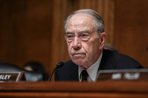
Sen. Grassley Questions Immigration Parole For New Alleged Trump Assassination Plotter
Authored by Naveen Athrappully via The Epoch Times (emphasis ours),
Sen. Charles Grassley (R-Iowa) posed a series of questions to the Department of Homeland Security (DHS) seeking clarity on the recent arrest of a Pakistani national regarding his attempts to assassinate high-ranking U.S. government officials, allegedly including former President Donald Trump, in light of the fact that he was flagged on a federal watchlist and recently granted immigration parole.
The alleged Pakistani plotter, Asif Raza Merchant, 46, was apprehended on July 12, 2024, when he attempted to leave the United States. Currently in federal custody in New York, Merchant’s plot was foiled when he allegedly conspired with undercover agents, who posed as assassins, to attempt to murder high-ranking U.S. citizens.
The alleged scheme was conducted as part of a larger Iranian ploy to retaliate against the killing of General Qasem Soleimani, Attorney General Merrick B. Garland said, according to an Aug. 6 Justice Department (DOJ) statement that revealed the incident. Soleimani was taken down in 2020 during the Trump administration for aiming to blow up the U.S. Embassy in Iraq.
On Aug. 9, Grassley wrote a letter to DHS Secretary Alejandro Mayorkas asking him for more information regarding Merchant’s immigration parole status. Citing media reports, Grassley said that Merchant was interviewed by the Joint Terrorism Task Force upon his arrival in the United States on April 13 because he was flagged in the federal database as a “Lookout Qualified Person of Interest.”
Despite this, Merchant was granted Significant Public Benefit Parole on April 13 by the DHS, which he overstayed after it expired on May 11, Grassley said. He asked the DHS to provide answers to the following:
- Did the DHS grant Merchant Significant Public Benefit Parole before or after his placement on the terrorist watchlist and being listed as a “Lookout Qualified Person of Interest”?
- On what basis was Merchant granted Significant Public Benefit Parole?
- Provide the entire Alien Registration File (A-File) for Asif Raza Merchant.
- How many individuals on the Terrorist Screening Database have DHS granted parole and allowed entry into the United States?
Following Merchant’s arrest, Garland said, “The Justice Department will spare no resource to disrupt and hold accountable those who would seek to carry out Iran’s lethal plotting against American citizens and will not tolerate attempts by an authoritarian regime to target American public officials and endanger America’s national security.”
FBI Director Christopher Wray said of the incident: “This dangerous murder-for-hire plot exposed in today’s complaint allegedly was orchestrated by a Pakistani national with close ties to Iran and is straight out of the Iranian playbook.
“A foreign-directed plot to kill a public official, or any U.S. citizen, is a threat to our national security and will be met with the full might and resources of the FBI.”
Assassination Attempts on Trump
The Pakistani national’s plan to assassinate Trump has not been confirmed by federal agencies. The Epoch Times reached out to the DHS and the DOJ for comment regarding the issue. The FBI declined to comment.
According to court documents, Merchant’s plot involved “three different criminal schemes: (1) stealing documents or USB drives from a target’s home; (2) planning a protest; and (3) killing a politician or government official.”
Merchant told the confidential source, an undercover agent, that “trusted” people would be needed to conduct the killing and perform protests after the incident as a distraction, and that they would need “a woman to do ‘reconnaissance.’”
Merchant paid the agent an advance sum of $5,000 to hire hitmen and told him that the final plans would be revealed after Merchant left the country.
He was subsequently arrested on July 12, a day before Trump was shot in the ear in an assassination attempt during a rally in Butler, Pennsylvania.
“The failure of the Secret Service in Butler, Pennsylvania, is even more outrageous in light of suspected Iranian-backed assassins targeting former Trump Administration officials, including President Trump himself. That day, the threat of sniper attacks was even higher than normal,” House Permanent Select Committee on Intelligence Chairman Mike Turner (R-Ohio) said in a statement after the DOJ unsealed its charges against Merchant.
“I was previously briefed concerning the Iranian threat and the circumstances of Mr. Merchant’s arrest and questioned then-Secret Service Director Kimberly Cheatle on whether she had reviewed the intelligence concerning the Iranian threat. She confirmed to me that she read the intelligence and was aware of this Iranian murder-for-hire plot.”
Loading…
Originally Posted at; https://www.zerohedge.com//
Stay Updated with news.freeptomaineradio.com’s Daily Newsletter
Stay informed! Subscribe to our daily newsletter to receive updates on our latest blog posts directly in your inbox. Don’t let important information get buried by big tech.
Current subscribers:

Donald Trump, Elon Musk: ‘We Don’t Have a President Right Now’
Former President Donald Trump and X owner Elon Musk agreed that the United States does not “have a president right now” while speaking in an X Space on Monday.
“Biden is close to vegetable stage, in my opinion, I looked at him today on the beach, and I said, ‘Why would anybody allow him — the guy could barely walk. Does he have a political adviser that thinks this looks good? Because it looks so bad,” Trump said, referring to a recent video that surfaced of President Joe Biden at the beach.
Watch Below:
Biden — who held just one public event this week — is currently lounging on the beach in Delaware.
He has spent 40% of his entire presidency on vacation.
Who is running the country? pic.twitter.com/NAva2BLPMm
— RNC Research (@RNCResearch) August 10, 2024
“He can’t lift the chair,” Trump continued. “The chair weighs about three ounces. It’s meant for children and old people to lift, and he can’t lift it. The whole thing is crazy.”
Musk chimed in, adding, “It’s clearly, like, we just don’t have a president right now,” to which Trump replied, “You don’t have a president.”
Listen Below:
— Donald J. Trump (@realDonaldTrump) August 12, 2024
Trump went on to say that Vice President Kamala Harris is “going to be worse than him” if she is elected president “because she is a San Francisco liberal who destroyed San Francisco, and, then, as attorney general, she destroyed California.”
Trump continued:
What she has done to California is — well, you know better than I do. You just left California for a lot of those reasons — what she’s done with crime, with cashless bail, where you kill somebody. We have states where you kill somebody and they let you out right away. And then they never find the people unless they kill again, and then they let them out again.
“Our country is becoming a very dangerous place, and she is a radical left San Francisco liberal — and now she’s looking like she wants to be more Trump than Trump if that’s possible. I don’t think it’s possible, but she wants to be more Trump than Trump,” the 45th president added.
Trump was likely referring to Harris copying his campaign promise to eliminate taxes on tips during her campaign rally on Saturday.
Ironically, Harris voted in 2022 to pass legislation to allow the Internal Revenue Service (IRS) to track down workers’ tips so that they could be taxed.
Harris cast the tie-breaking vote to pass the Inflation Reduction Act, which provided $80 billion in additional funding to the IRS, which then got to work cracking down on the service industry’s reporting of tips for taxation purposes.
You can follow Alana Mastrangelo on Facebook and X at @ARmastrangelo, and on Instagram.
Originally Posted At www.breitbart.com
Stay Updated with news.freeptomaineradio.com’s Daily Newsletter
Stay informed! Subscribe to our daily newsletter to receive updates on our latest blog posts directly in your inbox. Don’t let important information get buried by big tech.
Current subscribers:

Trump: ‘A Lot of People Just Don’t Have the Money’ for Groceries
Former President Donald Trump spoke about how “a lot of people” do not have the funds to be able to afford “a whole cart” of groceries.
“We’ve got to get the prices down,” Trump told Elon during a live interview on X. “You know, when I look at bacon costing four or five times more than it did a few years ago. When you look at some of the food products in grocery stores, people know — they can’t believe it. They used to be able to buy a whole cart, and today, a lot of people just don’t have the money. They go in and they can’t buy anything.”
During the interview, Trump also spoke about how people in the country “can’t buy groceries because they don’t have enough money.”
“The election’s coming, and the people want to hear about the economy and the fact that they can’t buy groceries because they don’t have enough money to buy groceries,” Trump said. “The inflation has killed them, food prices are up 50, 60, even 100 percent in some cases.”
Under the Biden administration, grocery prices have increased. In 2021, the prices for food increased by 6.3 percent, and 10.4 percent in 2022, according to TheStreet. In 2023, the increase in food prices “slowed” to 2.7 percent.
The outlet noted that supply chain issues, increasing production costs, and higher demand were some of the factors behind food prices increasing.
Originally Posted At www.breitbart.com
Stay Updated with news.freeptomaineradio.com’s Daily Newsletter
Stay informed! Subscribe to our daily newsletter to receive updates on our latest blog posts directly in your inbox. Don’t let important information get buried by big tech.
Current subscribers: