
Issued at 1500 UTC TUE AUG 20 2024
Category: Weather
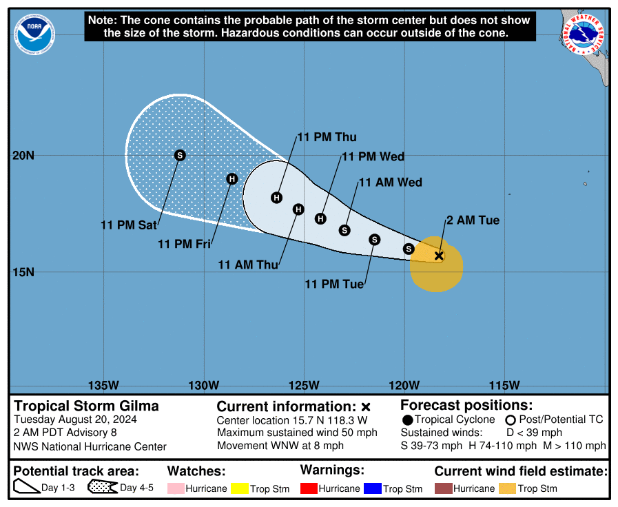
TROPICAL STORM GILMA

Tropical Storm Gilma Forecast Discussion
Issued at 200 AM PDT Tue Aug 20 2024
000
WTPZ42 KNHC 200840
TCDEP2

Tropical Storm Gilma Discussion Number   8
NWS National Hurricane Center Miami FL       EP072024
200 AM PDT Tue Aug 20 2024

Gilma continues to struggle with moderate to strong northeasterly
vertical wind shear. The center is exposed more than 30 n mi to the
northeast of the main convective overcast area. A 20/0129 UTC SSMIS
pass and a pair of more recent ASCAT passes were helpful in placing
the center well outside of the convective area. The highest
reliable ASCAT vectors were only about 40 kt. UW-CIMSS objective
intensity estimates range from 34-42 kt. Subjective current
intensity estimates from TAFB and SAB were T-3.5/55 kt and T-3.0/45
kt from SAB. Based on the degraded structure on satellite imagery,
the ASCAT data and the objective intensity estimates from UW-CIMSS,
the initial intensity is set to 45 kt for this advisory.

The aforementioned microwave and ASCAT data indicate that the
center of the cyclone is a bit farther north than previously
estimated. It appears that Gilma has slowed down, and the motion is
estimated to be west-northwestward, or 295/7 kt. A mid-level ridge
to the north of Gilma should steer the cyclone generally
west-northwestward at a similar forward speed through the forecast
period. Although the track guidance is gradually coming into better
agreement, there is still more spread than normal among the various
track aids. The official track forecast is quite similar to the
previous NHC track prediction. The NHC forecast track is closer to
the ECMWF model than the GFS model through 72 h, and is close to an
average of those two models beyond 72 h.

Moderate to strong northeasterly vertical wind shear will continue
to affect Gilma for another 12 h or so. The SHIPS guidance indicates
that the cyclone will reach a much lower wind shear regime by 24 h.
Therefore, little change in strength is expected during the next
12-24 h, following by steady intensification. The official intensity
forecast was lowered in the short term due to the weaker initial
intensity. However, the guidance has become more aggressive after
the cyclone reaches the weaker shear, and the NHC forecast follows
suit, now showing a peak of 85 kt in 60-72 hr. The new NHC intensity
forecast is near the middle of the guidance envelope, in between the
weaker statistical guidance and the stronger regional hurricane
model dynamical guidance. SSTs along Gilma's path should decrease to
about 26C in 72 h, and remain at that value through 96 h before
dropping to below 26C. Weakening is forecast during that time
period.


FORECAST POSITIONS AND MAX WINDS

INIT  20/0900Z 15.7N 118.3W   45 KT  50 MPH
 12H  20/1800Z 16.0N 119.8W   45 KT  50 MPH
 24H  21/0600Z 16.4N 121.5W   50 KT  60 MPH
 36H  21/1800Z 16.8N 123.0W   60 KT  70 MPH
 48H  22/0600Z 17.3N 124.2W   70 KT  80 MPH
 60H  22/1800Z 17.7N 125.3W   85 KT 100 MPH
 72H  23/0600Z 18.2N 126.4W   85 KT 100 MPH
 96H  24/0600Z 19.0N 128.6W   75 KT  85 MPH
120H  25/0600Z 20.0N 131.2W   60 KT  70 MPH

$$
Forecaster Hagen/Pasch
Tropical Storm Gilma Wind Speed Probabilities
Issued at 0900 UTC TUE AUG 20 2024
Tropical Storm Gilma Public Advisory
…GILMA CONTINUES TO BATTLE STRONG WIND SHEAR…
As of 2:00 AM PDT Tue Aug 20
the center of Gilma was located near 15.7, -118.3
with movement WNW at 8 mph.
The minimum central pressure was 1000 mb
with maximum sustained winds of about 50 mph.
Hurricane Ernesto Forecast Discussion
Issued at 500 AM AST Tue Aug 20 2024
Tropical Storm Gilma Forecast Advisory
Issued at 0900 UTC TUE AUG 20 2024
Hurricane Ernesto Public Advisory
…ERNESTO MOVING RAPIDLY AWAY FROM NEWFOUNDLAND… …DANGEROUS BEACH CONDITIONS CONTINUING ALONG THE NORTHEAST U.S. COAST AND ATLANTIC CANADA…
As of 5:00 AM AST Tue Aug 20
the center of Ernesto was located near 47.3, -50.0
with movement NE at 36 mph.
The minimum central pressure was 975 mb
with maximum sustained winds of about 75 mph.
Hurricane Ernesto Forecast Advisory
Issued at 0900 UTC TUE AUG 20 2024
Hurricane Ernesto Public Advisory
…DANGEROUS BEACH CONDITIONS CONTINUING ALONG THE NORTHEAST U.S. COAST AND ATLANTIC CANADA… …ERNESTO PASSING SOUTH OF SOUTHEASTERN NEWFOUNDLAND…
As of 11:00 PM AST Mon Aug 19
the center of Ernesto was located near 45.7, -53.1
with movement NE at 35 mph.
The minimum central pressure was 973 mb
with maximum sustained winds of about 80 mph.