


Tropical Storm Gilma Forecast Advisory
850
WTPZ22 KNHC 190841
TCMEP2

TROPICAL STORM GILMA FORECAST/ADVISORY NUMBER   4
NWS NATIONAL HURRICANE CENTER MIAMI FL       EP072024
0900 UTC MON AUG 19 2024

TROPICAL STORM CENTER LOCATED NEAR 15.0N 114.6W AT 19/0900Z
POSITION ACCURATE WITHIN  30 NM

PRESENT MOVEMENT TOWARD THE WEST OR 280 DEGREES AT  11 KT

ESTIMATED MINIMUM CENTRAL PRESSURE 1000 MB
MAX SUSTAINED WINDS  45 KT WITH GUSTS TO  55 KT.
34 KT....... 40NE  30SE   0SW  40NW.
WINDS AND SEAS VARY GREATLY IN EACH QUADRANT.  RADII IN NAUTICAL
MILES ARE THE LARGEST RADII EXPECTED ANYWHERE IN THAT QUADRANT.

REPEAT...CENTER LOCATED NEAR 15.0N 114.6W AT 19/0900Z
AT 19/0600Z CENTER WAS LOCATED NEAR 14.9N 114.1W

FORECAST VALID 19/1800Z 15.2N 116.3W
MAX WIND  45 KT...GUSTS  55 KT.
34 KT... 40NE  40SE   0SW  40NW.

FORECAST VALID 20/0600Z 15.5N 118.2W
MAX WIND  50 KT...GUSTS  60 KT.
50 KT... 20NE   0SE   0SW   0NW.
34 KT... 40NE  60SE  30SW  40NW.

FORECAST VALID 20/1800Z 16.0N 119.8W
MAX WIND  50 KT...GUSTS  60 KT.
50 KT... 20NE  20SE   0SW   0NW.
34 KT... 50NE  60SE  40SW  40NW.

FORECAST VALID 21/0600Z 16.7N 121.5W
MAX WIND  55 KT...GUSTS  65 KT.
50 KT... 20NE  30SE   0SW   0NW.
34 KT... 70NE  70SE  60SW  60NW.

FORECAST VALID 21/1800Z 17.3N 122.7W
MAX WIND  65 KT...GUSTS  80 KT.
50 KT... 30NE  30SE  20SW  30NW.
34 KT... 70NE  70SE  60SW  60NW.

FORECAST VALID 22/0600Z 17.8N 123.9W
MAX WIND  70 KT...GUSTS  85 KT.
50 KT... 30NE  30SE  30SW  30NW.
34 KT... 80NE  80SE  60SW  70NW.

EXTENDED OUTLOOK. NOTE...ERRORS FOR TRACK HAVE AVERAGED NEAR 100 NM
ON DAY 4 AND 125 NM ON DAY 5...AND FOR INTENSITY NEAR 15 KT EACH DAY

OUTLOOK VALID 23/0600Z 18.6N 125.9W
MAX WIND  70 KT...GUSTS  85 KT.
50 KT... 30NE  30SE  30SW  30NW.
34 KT... 80NE  80SE  60SW  80NW.

OUTLOOK VALID 24/0600Z 19.5N 128.3W
MAX WIND  60 KT...GUSTS  75 KT.
50 KT... 30NE  30SE  30SW  30NW.
34 KT... 80NE  70SE  60SW  80NW.

REQUEST FOR 3 HOURLY SHIP REPORTS WITHIN 300 MILES OF 15.0N 114.6W

NEXT ADVISORY AT 19/1500Z

$$
FORECASTER HAGEN/PASCH
Originally Posted at:
NATIONAL HURRICANE CENTER and CENTRAL PACIFIC HURRICANE CENTER
At The NATIONAL OCEANIC AND ATMOSPHERIC ADMINISTRATION
Stay Updated with news.freeptomaineradio.com’s Daily Newsletter
Stay informed! Subscribe to our daily newsletter to receive updates on our latest blog posts directly in your inbox. Don’t let important information get buried by big tech.
Current subscribers:
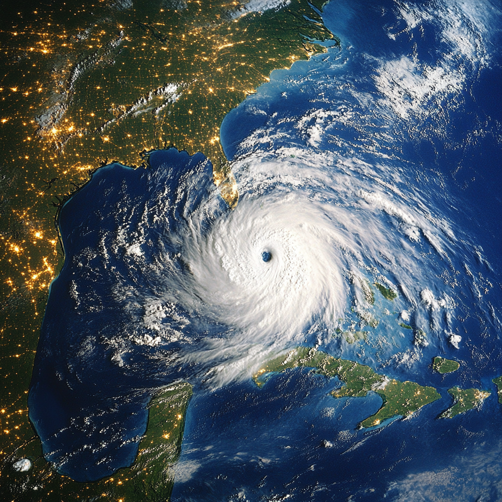
Hurricane Ernesto Forecast Advisory
849
WTNT25 KNHC 190841
TCMAT5

HURRICANE ERNESTO FORECAST/ADVISORY NUMBER  31
NWS NATIONAL HURRICANE CENTER MIAMI FL       AL052024
0900 UTC MON AUG 19 2024

HURRICANE CENTER LOCATED NEAR 40.2N  60.5W AT 19/0900Z
POSITION ACCURATE WITHIN  20 NM

PRESENT MOVEMENT TOWARD THE NORTH-NORTHEAST OR  30 DEGREES AT  18 KT

ESTIMATED MINIMUM CENTRAL PRESSURE  972 MB
MAX SUSTAINED WINDS  75 KT WITH GUSTS TO  90 KT.
64 KT....... 30NE  30SE   0SW   0NW.
50 KT....... 70NE  70SE  40SW  50NW.
34 KT.......160NE 190SE 110SW 100NW.
12 FT SEAS..270NE 270SE 240SW 180NW.
WINDS AND SEAS VARY GREATLY IN EACH QUADRANT.  RADII IN NAUTICAL
MILES ARE THE LARGEST RADII EXPECTED ANYWHERE IN THAT QUADRANT.

REPEAT...CENTER LOCATED NEAR 40.2N  60.5W AT 19/0900Z
AT 19/0600Z CENTER WAS LOCATED NEAR 39.3N  61.1W

FORECAST VALID 19/1800Z 42.7N  57.3W
MAX WIND  75 KT...GUSTS  90 KT.
64 KT... 30NE  35SE  25SW   0NW.
50 KT... 60NE  70SE  50SW  40NW.
34 KT...150NE 180SE 120SW  90NW.

FORECAST VALID 20/0600Z 46.3N  51.0W...POST-TROPICAL
MAX WIND  65 KT...GUSTS  80 KT.
64 KT... 30NE  35SE  25SW   0NW.
50 KT... 50NE  70SE  50SW  30NW.
34 KT...130NE 180SE 150SW  70NW.

FORECAST VALID 20/1800Z 49.0N  41.8W...POST-TROP/EXTRATROP
MAX WIND  50 KT...GUSTS  60 KT.
50 KT... 40NE  60SE  40SW   0NW.
34 KT...100NE 170SE 170SW  50NW.

FORECAST VALID 21/0600Z 50.8N  30.8W...POST-TROP/EXTRATROP
MAX WIND  40 KT...GUSTS  50 KT.
34 KT... 90NE 170SE 170SW   0NW.

FORECAST VALID 21/1800Z 53.0N  19.5W...POST-TROP/EXTRATROP
MAX WIND  35 KT...GUSTS  45 KT.
34 KT...  0NE 170SE 130SW   0NW.

FORECAST VALID 22/0600Z...DISSIPATED

REQUEST FOR 3 HOURLY SHIP REPORTS WITHIN 300 MILES OF 40.2N  60.5W

NEXT ADVISORY AT 19/1500Z

$$
FORECASTER PASCH
Originally Posted at:
NATIONAL HURRICANE CENTER and CENTRAL PACIFIC HURRICANE CENTER
At The NATIONAL OCEANIC AND ATMOSPHERIC ADMINISTRATION
Stay Updated with news.freeptomaineradio.com’s Daily Newsletter
Stay informed! Subscribe to our daily newsletter to receive updates on our latest blog posts directly in your inbox. Don’t let important information get buried by big tech.
Current subscribers:
Tropical Storm Gilma Forecast Discussion
000
WTPZ42 KNHC 190240
TCDEP2

Tropical Storm Gilma Discussion Number   3
NWS National Hurricane Center Miami FL       EP072024
800 PM MST Sun Aug 18 2024

Gilma continues to battle easterly shear this evening.
Deep convection has been regularly pulsing near the center and
then pulled off toward the western side of the circulation.
Subjective Dvorak estimates from TAFB and SAB were T3.0/45 kt and
T2.0/30 kt, respectively.  Objective intensity estimates range from
30 to 38 kt.  The initial intensity is held at 35 kt, representing a
blend of the various estimates.

Strong-to-moderate deep vertical wind shear is forecast to persist
for the next day or two.  Global models vary when the shear will
relax, but sometime on Tuesday or Wednesday Gilma should be in a
more conducive environment and gradually strengthen.  By the end of
the forecast period, the storm is expected to move into a drier
airmass with increasing upper-level winds, which should induce
gradual weakening.  The latest intensity forecast is very similar to
the previous prediction, slightly higher than the various consensus
aids.

Gilma is moving westward along the south side of a mid-level ridge
at 280/11 kt.  A westward to west-northwestward motion should
continue for the next couple of days.  By Wednesday, Gilma is
expected to slow down and turn more northwestward when a trough
off of the west coast of the United States erodes the ridge.  There
is quite a bit of model spread during this period, with the GFS
showing a slower forward speed and a more poleward turn compared to
some of the regional models which stay farther to the south and
move faster.  The official track forecast lies near the simple
consensus aids and is slightly south of the previous track through
60 h and a little to the north afterwards.


FORECAST POSITIONS AND MAX WINDS

INIT  19/0300Z 14.8N 113.5W   35 KT  40 MPH
 12H  19/1200Z 15.2N 115.2W   40 KT  45 MPH
 24H  20/0000Z 15.5N 117.3W   40 KT  45 MPH
 36H  20/1200Z 15.8N 119.2W   45 KT  50 MPH
 48H  21/0000Z 16.3N 120.7W   50 KT  60 MPH
 60H  21/1200Z 17.1N 122.5W   55 KT  65 MPH
 72H  22/0000Z 17.5N 123.5W   60 KT  70 MPH
 96H  23/0000Z 18.3N 125.5W   70 KT  80 MPH
120H  24/0000Z 19.1N 127.8W   65 KT  75 MPH

$$
Forecaster Bucci
Originally Posted at:
NATIONAL HURRICANE CENTER and CENTRAL PACIFIC HURRICANE CENTER At The NATIONAL OCEANIC AND ATMOSPHERIC ADMINISTRATION
Stay Updated with news.freeptomaineradio.com’s Daily Newsletter
Stay informed! Subscribe to our daily newsletter to receive updates on our latest blog posts directly in your inbox. Don’t let important information get buried by big tech.
Current subscribers:
Tropical Storm Gilma Public Advisory
000
WTPZ32 KNHC 190240
TCPEP2

BULLETIN
Tropical Storm Gilma Advisory Number   3
NWS National Hurricane Center Miami FL       EP072024
800 PM MST Sun Aug 18 2024

...GILMA HEADING WESTWARD AND HOLDING STEADY...


SUMMARY OF 800 PM MST...0300 UTC...INFORMATION
----------------------------------------------
LOCATION...14.8N 113.5W
ABOUT 605 MI...975 KM SSW OF THE SOUTHERN TIP OF BAJA CALIFORNIA
MAXIMUM SUSTAINED WINDS...40 MPH...65 KM/H
PRESENT MOVEMENT...W OR 280 DEGREES AT 13 MPH...20 KM/H
MINIMUM CENTRAL PRESSURE...1005 MB...29.68 INCHES


WATCHES AND WARNINGS
--------------------
There are no coastal watches or warnings in effect.


DISCUSSION AND OUTLOOK
----------------------
At 800 PM MST (0300 UTC), the center of Tropical Storm Gilma was
located near latitude 14.8 North, longitude 113.5 West. Gilma is
moving toward the west near 13 mph (20 km/h).  A slightly slower
westward to west-northwestward motion is expected during the next
few days.  Gilma is forecast to remain well away from land
throughout the week.

Maximum sustained winds are near 40 mph (65 km/h) with higher gusts.
Slow strengthening is expected during the next few days.

Tropical-storm-force winds extend outward up to 45 miles (75 km)
from the center.

The estimated minimum central pressure is 1005 mb (29.68 inches).


HAZARDS AFFECTING LAND
----------------------
None


NEXT ADVISORY
-------------
Next complete advisory at 200 AM MST.

$$
Forecaster Bucci
Originally Posted at:
NATIONAL HURRICANE CENTER and CENTRAL PACIFIC HURRICANE CENTER At The NATIONAL OCEANIC AND ATMOSPHERIC ADMINISTRATION
Stay Updated with news.freeptomaineradio.com’s Daily Newsletter
Stay informed! Subscribe to our daily newsletter to receive updates on our latest blog posts directly in your inbox. Don’t let important information get buried by big tech.
Current subscribers:
Tropical Storm Gilma Forecast Advisory
000
WTPZ22 KNHC 190240
TCMEP2

TROPICAL STORM GILMA FORECAST/ADVISORY NUMBER   3
NWS NATIONAL HURRICANE CENTER MIAMI FL       EP072024
0300 UTC MON AUG 19 2024

TROPICAL STORM CENTER LOCATED NEAR 14.8N 113.5W AT 19/0300Z
POSITION ACCURATE WITHIN  30 NM

PRESENT MOVEMENT TOWARD THE WEST OR 280 DEGREES AT  11 KT

ESTIMATED MINIMUM CENTRAL PRESSURE 1005 MB
MAX SUSTAINED WINDS  35 KT WITH GUSTS TO  45 KT.
34 KT....... 40NE   0SE   0SW  40NW.
WINDS AND SEAS VARY GREATLY IN EACH QUADRANT.  RADII IN NAUTICAL
MILES ARE THE LARGEST RADII EXPECTED ANYWHERE IN THAT QUADRANT.

REPEAT...CENTER LOCATED NEAR 14.8N 113.5W AT 19/0300Z
AT 19/0000Z CENTER WAS LOCATED NEAR 14.7N 113.0W

FORECAST VALID 19/1200Z 15.2N 115.2W
MAX WIND  40 KT...GUSTS  50 KT.
34 KT... 40NE  30SE   0SW  40NW.

FORECAST VALID 20/0000Z 15.5N 117.3W
MAX WIND  40 KT...GUSTS  50 KT.
34 KT... 40NE  30SE   0SW  40NW.

FORECAST VALID 20/1200Z 15.8N 119.2W
MAX WIND  45 KT...GUSTS  55 KT.
34 KT... 50NE  50SE  20SW  40NW.

FORECAST VALID 21/0000Z 16.3N 120.7W
MAX WIND  50 KT...GUSTS  60 KT.
50 KT... 20NE   0SE   0SW   0NW.
34 KT... 60NE  50SE  30SW  50NW.

FORECAST VALID 21/1200Z 17.1N 122.5W
MAX WIND  55 KT...GUSTS  65 KT.
50 KT... 30NE   0SE   0SW  20NW.
34 KT... 70NE  60SE  40SW  60NW.

FORECAST VALID 22/0000Z 17.5N 123.5W
MAX WIND  60 KT...GUSTS  75 KT.
50 KT... 30NE  20SE   0SW  30NW.
34 KT... 80NE  70SE  50SW  70NW.

EXTENDED OUTLOOK. NOTE...ERRORS FOR TRACK HAVE AVERAGED NEAR 100 NM
ON DAY 4 AND 125 NM ON DAY 5...AND FOR INTENSITY NEAR 15 KT EACH DAY

OUTLOOK VALID 23/0000Z 18.3N 125.5W
MAX WIND  70 KT...GUSTS  85 KT.
50 KT... 30NE  20SE  20SW  30NW.
34 KT... 80NE  70SE  50SW  70NW.

OUTLOOK VALID 24/0000Z 19.1N 127.8W
MAX WIND  65 KT...GUSTS  80 KT.
50 KT... 30NE  20SE  20SW  30NW.
34 KT... 80NE  70SE  50SW  80NW.

REQUEST FOR 3 HOURLY SHIP REPORTS WITHIN 300 MILES OF 14.8N 113.5W

NEXT ADVISORY AT 19/0900Z

$$
FORECASTER BUCCI
Originally Posted at:
NATIONAL HURRICANE CENTER and CENTRAL PACIFIC HURRICANE CENTER
At The NATIONAL OCEANIC AND ATMOSPHERIC ADMINISTRATION
Stay Updated with news.freeptomaineradio.com’s Daily Newsletter
Stay informed! Subscribe to our daily newsletter to receive updates on our latest blog posts directly in your inbox. Don’t let important information get buried by big tech.
Current subscribers:
Tropical Storm Gilma Wind Speed Probabilities
000
FOPZ12 KNHC 190240
PWSEP2

TROPICAL STORM GILMA WIND SPEED PROBABILITIES NUMBER   3
NWS NATIONAL HURRICANE CENTER MIAMI FL       EP072024
0300 UTC MON AUG 19 2024

AT 0300Z THE CENTER OF TROPICAL STORM GILMA WAS LOCATED NEAR
LATITUDE 14.8 NORTH...LONGITUDE 113.5 WEST WITH MAXIMUM SUSTAINED
WINDS NEAR 35 KTS...40 MPH...65 KM/H.

Z INDICATES COORDINATED UNIVERSAL TIME (GREENWICH)
   PACIFIC  DAYLIGHT TIME (PDT)...SUBTRACT 7 HOURS FROM Z TIME
   HAWAIIAN STANDARD TIME (HST)...SUBTRACT 10 HOURS FROM Z TIME

WIND SPEED PROBABILITY TABLE FOR SPECIFIC LOCATIONS

CHANCES OF SUSTAINED (1-MINUTE AVERAGE) WIND SPEEDS OF AT LEAST
   ...34 KT (39 MPH... 63 KM/H)...
   ...50 KT (58 MPH... 93 KM/H)...
   ...64 KT (74 MPH...119 KM/H)...
FOR LOCATIONS AND TIME PERIODS DURING THE NEXT 5 DAYS

PROBABILITIES FOR LOCATIONS ARE GIVEN AS OP(CP) WHERE
    OP  IS THE PROBABILITY OF THE EVENT BEGINNING DURING
        AN INDIVIDUAL TIME PERIOD (ONSET PROBABILITY)
   (CP) IS THE PROBABILITY OF THE EVENT OCCURRING BETWEEN
        00Z MON AND THE FORECAST HOUR (CUMULATIVE PROBABILITY)

PROBABILITIES ARE GIVEN IN PERCENT
X INDICATES PROBABILITIES LESS THAN 1 PERCENT
PROBABILITIES FOR 34 KT AND 50 KT ARE SHOWN AT A GIVEN LOCATION WHEN
THE 5-DAY CUMULATIVE PROBABILITY IS AT LEAST 3 PERCENT.
PROBABILITIES FOR 34...50...64 KT SHOWN WHEN THE 5-DAY
64-KT CUMULATIVE PROBABILITY IS AT LEAST 1 PERCENT.


  - - - - WIND SPEED PROBABILITIES FOR SELECTED LOCATIONS - - - -

               FROM    FROM    FROM    FROM    FROM    FROM    FROM
  TIME       00Z MON 12Z MON 00Z TUE 12Z TUE 00Z WED 00Z THU 00Z FRI
PERIODS         TO      TO      TO      TO      TO      TO      TO
             12Z MON 00Z TUE 12Z TUE 00Z WED 00Z THU 00Z FRI 00Z SAT

FORECAST HOUR    (12)   (24)    (36)    (48)    (72)    (96)   (120)
- - - - - - - - - - - - - - - - - - - - - - - - - - - - - - - - - -
LOCATION       KT

15N 115W       34 48   2(50)   X(50)   X(50)   X(50)   X(50)   X(50)
15N 115W       50  5   1( 6)   X( 6)   X( 6)   X( 6)   X( 6)   X( 6)

15N 120W       34  X   2( 2)  14(16)  12(28)   2(30)   1(31)   X(31)
15N 120W       50  X   X( X)   2( 2)   3( 5)   1( 6)   X( 6)   X( 6)
15N 120W       64  X   X( X)   X( X)   1( 1)   X( 1)   X( 1)   X( 1)

20N 120W       34  X   X( X)   1( 1)   3( 4)   4( 8)   2(10)   X(10)

15N 125W       34  X   X( X)   X( X)   1( 1)   7( 8)   5(13)   1(14)

20N 125W       34  X   X( X)   X( X)   X( X)  12(12)  28(40)   7(47)
20N 125W       50  X   X( X)   X( X)   X( X)   1( 1)   9(10)   4(14)
20N 125W       64  X   X( X)   X( X)   X( X)   X( X)   4( 4)   1( 5)

15N 130W       34  X   X( X)   X( X)   X( X)   X( X)   1( 1)   3( 4)

20N 130W       34  X   X( X)   X( X)   X( X)   X( X)   4( 4)  18(22)
20N 130W       50  X   X( X)   X( X)   X( X)   X( X)   1( 1)   4( 5)
20N 130W       64  X   X( X)   X( X)   X( X)   X( X)   X( X)   2( 2)

$$
FORECASTER BUCCI
Originally Posted at:
NATIONAL HURRICANE CENTER and CENTRAL PACIFIC HURRICANE CENTER
At The NATIONAL OCEANIC AND ATMOSPHERIC ADMINISTRATION
Stay Updated with news.freeptomaineradio.com’s Daily Newsletter
Stay informed! Subscribe to our daily newsletter to receive updates on our latest blog posts directly in your inbox. Don’t let important information get buried by big tech.
Current subscribers:
Hurricane Ernesto Forecast Discussion
213
WTNT45 KNHC 190234
TCDAT5

Hurricane Ernesto Discussion Number  30
NWS National Hurricane Center Miami FL       AL052024
1100 PM AST Sun Aug 18 2024

Ernesto continues to have a good structure this evening with a
partly cloud-filled eye surrounded by bands of convection, although
the convective cloud tops are not quite as cold as they were 6 h
ago. Subjective Dvorak intensity estimates from TAFB and SAB are now
near 65 kt, while various objective estimates are now near 75 kt.
The initial intensity is increased to 70 kt based on a blend of
these data.

Some additional strengthening is possible during the next 6-12 h
before Ernesto moves north of the north wall of the Gulf Stream.
After that, the system should quickly decay as it moves over colder
water and encounters increasing southwesterly shear.  The cyclone
should become an extratropical low by 36 h as it passes south of
southeastern Newfoundland, and by 72 h it should be absorbed into a
larger non-tropical low developing south of Iceland.  The new
intensity forecast is near the upper edge of the intensity guidance
for the first 12 h, and after that lies near the intensity
consensus.

The initial motion is now 030/17 kt. A northeastward motion at a
faster forward speed is expected over the next 24-36 h as Ernesto
becomes caught up in the flow between a large deep-layer trough
over the eastern U.S. and a subtropical ridge centered to the
hurricane's southeast. This motion should bring the center south
of southeastern Newfoundland late Monday night or early Tuesday
morning, with most of the wind field staying offshore.  A more
east-northeastward motion is expected thereafter before the cyclone
becomes absorbed by the aforementioned larger extratropical
cyclone. The tightly clustered track guidance has shifted a little
to the north since the last advisory, so the new track forecast is a
little north of the previous track.


Key Messages:

1. Even though Ernesto is forecast to remain well offshore of the
U.S. East Coast, swells generated by the hurricane will continue to
affect the area through the early part of this week.  Beach goers
should be aware that there is a significant risk of life-threatening
surf and rip currents, and should stay out of the water if advised
by lifeguards.  Surf and rip currents are also possible on the
Bahamas, Bermuda, and Atlantic Canada during the next few days.

2. Ernesto could bring wind, wave, and rain impacts to portions of
southeastern Newfoundland Monday night into Tuesday morning.
Breaking waves could bring the possibility of coastal flooding,
particularly along southwest-facing shorelines from Bunin east to
Avalon regions. For additional impact specific information, please
see statements issued by the Canadian Hurricane Centre.


FORECAST POSITIONS AND MAX WINDS

INIT  19/0300Z 38.5N  61.4W   70 KT  80 MPH
 12H  19/1200Z 40.9N  59.3W   75 KT  85 MPH
 24H  20/0000Z 44.3N  54.3W   65 KT  75 MPH
 36H  20/1200Z 47.4N  46.6W   55 KT  65 MPH...POST-TROP/EXTRATROP
 48H  21/0000Z 50.0N  35.5W   45 KT  50 MPH...POST-TROP/EXTRATROP
 60H  21/1200Z 52.5N  24.0W   40 KT  45 MPH...POST-TROP/EXTRATROP
 72H  22/0000Z...DISSIPATED

$$
Forecaster Beven
Originally Posted at:
NATIONAL HURRICANE CENTER and CENTRAL PACIFIC HURRICANE CENTER
At The NATIONAL OCEANIC AND ATMOSPHERIC ADMINISTRATION
Stay Updated with news.freeptomaineradio.com’s Daily Newsletter
Stay informed! Subscribe to our daily newsletter to receive updates on our latest blog posts directly in your inbox. Don’t let important information get buried by big tech.
Current subscribers:
Hurricane Ernesto Public Advisory
000
WTNT35 KNHC 190233
TCPAT5
BULLETIN
Hurricane Ernesto Advisory Number 30
NATIONAL WEATHER SERVICE, National Hurricane Center Miami FLORIDA AL052024
11:00 P.M. ATLANTIC STANDARD TIME Sun Aug 18 2024
- ERNESTO STRENGTHENS A LITTLE
- DANGEROUS BEACH CONDITIONS OCCURING ALONG THE U.S. EAST COAST AND ATLANTIC CANADA THROUGH EARLY THIS WEEK
SUMMARY OF 11:00 P.M. ATLANTIC STANDARD TIME 03:00 COORDINATED UNIVERSAL TIME INFORMATION
LOCATION 38.5 NORTH 61.4 WEST
ABOUT 435 MILES, 700 KILOMETERS SOUTH SOUTHEAST, OF HALIFAX NOVA SCOTIA
ABOUT 705 MILES, 1135 KILOMETERS SOUTHWEST, OF CAPE RACE NEWFOUNDLAND
MAXIMUM SUSTAINED WINDS 80 MILES PER HOUR, 130 KILOMETERS PER HOUR
PRESENT MOVEMENT NORTH NORTHEAST, OR 30 DEGREES AT 20 MILES PER HOUR, 31 KILOMETERS PER HOUR
MINIMUM CENTRAL PRESSURE 975 MILLIBAR, 28.80 INCHES
WATCHES AND WARNINGS
CHANGES WITH THIS ADVISORY: None.
SUMMARY OF WATCHES AND WARNINGS IN EFFECT: There are no coastal watches or warnings in effect.
- Interests in southeastern Newfoundland should monitor the progress of Ernesto.
DISCUSSION AND OUTLOOK
- At 11:00 P.M. ATLANTIC STANDARD TIME (03:00 COORDINATED UNIVERSAL TIME), the center of Hurricane Ernesto was located near latitude 38.5 North, longitude 61.4 West.
- Ernesto is moving toward the north northeast near 20 Miles Per Hour, (31 Kilometers Per Hour), and this motion with some increase in forward speed is expected tonight.
- A turn toward the northeast and east northeast and an additional increase in forward speed are expected on Monday and Tuesday.
- On the forecast track, the center of Ernesto will pass near southeastern Newfoundland late Monday into Tuesday morning.
- Maximum sustained winds are near 80 Miles Per Hour, (130 Kilometers Per Hour) with higher gusts.
- Some additional strengthening is possible tonight.
- After that, Ernesto should weaken, and the cyclone is forecast to become post tropical on Tuesday.
- Hurricane force winds extend outward up to 35 miles (55 Kilometers) from the center and tropical storm force winds extend outward up to 220 miles (350 Kilometers).
- The estimated minimum central pressure is 975 Millibar, (28.80 inches).
HAZARDS AFFECTING LAND
Key messages for Ernesto can be found in the Tropical Cyclone Discussion under AWIPS header MIATCDAT5 and WMO header WTNT45 KNHC and on the web at
hurricanes.gov/text/MIATCDAT5.shtml
SURF:
- Swells generated by Ernesto are affecting portions of the Bahamas, Bermuda, the east coast of the United States, and Atlantic Canada.
- Life threatening surf and rip current conditions are likely to continue in these areas during the next couple of days.
- In southeastern Newfoundland large breaking waves could bring the possibility of coastal flooding, particularly along southwest facing shorelines from Burin east to Avalon regions.
- Please consult products from your local weather office, and stay out of the water if advised by lifeguards.
NEXT ADVISORY
- Next complete advisory at 5:00 A.M. ATLANTIC STANDARD TIME.
$$
Forecaster Beven
Originally Posted at:
NATIONAL HURRICANE CENTER and CENTRAL PACIFIC HURRICANE CENTER
At The NATIONAL OCEANIC AND ATMOSPHERIC ADMINISTRATION
Stay Updated with news.freeptomaineradio.com’s Daily Newsletter
Stay informed! Subscribe to our daily newsletter to receive updates on our latest blog posts directly in your inbox. Don’t let important information get buried by big tech.
Current subscribers:
Hurricane Ernesto Forecast Advisory
000
WTNT25 KNHC 190233
TCMAT5

HURRICANE ERNESTO FORECAST/ADVISORY NUMBER  30
NWS NATIONAL HURRICANE CENTER MIAMI FL       AL052024
0300 UTC MON AUG 19 2024

HURRICANE CENTER LOCATED NEAR 38.5N  61.4W AT 19/0300Z
POSITION ACCURATE WITHIN  20 NM

PRESENT MOVEMENT TOWARD THE NORTH-NORTHEAST OR  30 DEGREES AT  17 KT

ESTIMATED MINIMUM CENTRAL PRESSURE  975 MB
MAX SUSTAINED WINDS  70 KT WITH GUSTS TO  85 KT.
64 KT....... 30NE  30SE   0SW   0NW.
50 KT....... 70NE  70SE  40SW  50NW.
34 KT.......160NE 190SE 110SW 100NW.
12 FT SEAS..270NE 270SE 210SW 200NW.
WINDS AND SEAS VARY GREATLY IN EACH QUADRANT.  RADII IN NAUTICAL
MILES ARE THE LARGEST RADII EXPECTED ANYWHERE IN THAT QUADRANT.

REPEAT...CENTER LOCATED NEAR 38.5N  61.4W AT 19/0300Z
AT 19/0000Z CENTER WAS LOCATED NEAR 37.7N  62.0W

FORECAST VALID 19/1200Z 40.9N  59.3W
MAX WIND  75 KT...GUSTS  90 KT.
64 KT... 30NE  35SE  25SW   0NW.
50 KT... 60NE  70SE  50SW  40NW.
34 KT...150NE 180SE 110SW  90NW.

FORECAST VALID 20/0000Z 44.3N  54.3W
MAX WIND  65 KT...GUSTS  80 KT.
64 KT... 30NE  35SE   0SW   0NW.
50 KT... 50NE  70SE  50SW  30NW.
34 KT...130NE 170SE 130SW  70NW.

FORECAST VALID 20/1200Z 47.4N  46.6W...POST-TROP/EXTRATROP
MAX WIND  55 KT...GUSTS  65 KT.
50 KT... 40NE  60SE  40SW   0NW.
34 KT...100NE 170SE 150SW  50NW.

FORECAST VALID 21/0000Z 50.0N  35.5W...POST-TROP/EXTRATROP
MAX WIND  45 KT...GUSTS  55 KT.
34 KT... 90NE 170SE 170SW   0NW.

FORECAST VALID 21/1200Z 52.5N  24.0W...POST-TROP/EXTRATROP
MAX WIND  40 KT...GUSTS  50 KT.
34 KT...  0NE 170SE 130SW   0NW.

FORECAST VALID 22/0000Z...DISSIPATED

REQUEST FOR 3 HOURLY SHIP REPORTS WITHIN 300 MILES OF 38.5N  61.4W

NEXT ADVISORY AT 19/0900Z

$$
FORECASTER BEVEN
Originally Posted at:
NATIONAL HURRICANE CENTER and CENTRAL PACIFIC HURRICANE CENTER
At The NATIONAL OCEANIC AND ATMOSPHERIC ADMINISTRATION
Stay Updated with news.freeptomaineradio.com’s Daily Newsletter
Stay informed! Subscribe to our daily newsletter to receive updates on our latest blog posts directly in your inbox. Don’t let important information get buried by big tech.
Current subscribers:

STEPHEN DAVIS: Camping World retailer refuses to remove American flag from property after being ordered by CA county to do so
Camping World, a major RV retailer, is standing firm after being ordered by a Northern California county to remove a large American flag from its property.
The Camping World dealership in San Joaquin County flies a massive American flag, just like its 250 other locations across the U.S. However, in April, the county ordered the dealership to take down the flag, citing safety concerns and the lack of proper permits.
“Camping World’s flagpole was installed with neither a building permit nor planning approval, therefore they are in conversation with the code enforcement division,” the county claimed in a statement to Fox40.
Despite concerns about the flag’s proximity to a highway and potential hazards, Camping World CEO Marcus Lemonis instructed the location to reinstall the flag last week.
“If we felt like we were putting people in danger or causing any issues with air traffic, which would absolutely not be OK, then I wouldn’t do it,” Lemonis said.
Lemonis emphasized that the flagpole is securely anchored and poses no safety risk. He also stated that if the issue had involved any other flag, he would have no problem taking it down until a permit was obtained. However, because it is the American flag, he feels a strong obligation to keep it flying.
“It’s symbolism about how we feel about this country. We have a lot of veterans who work for us, and a lot of veterans who shop with us,” Lemonis explained. “I happen to be an immigrant. I was given the blessing of being able to enter this country and become a citizen, and I’m grateful for it. It’s been part of my life since I was a little child down in Miami, Florida, where we had the largest flag pole in Miami at our car dealership.”
The county noted that the flagpole exceeded the maximum height allowed without a permit but later clarified that they never explicitly ordered Camping World to remove the flag. After the story gained public attention, the county stated they would issue a permit following a review.
This piece first appeared at TPUSA.
This Story originally came from humanevents.com
Stay Updated with news.freeptomaineradio.com’s Daily Newsletter
Stay informed! Subscribe to our daily newsletter to receive updates on our latest blog posts directly in your inbox. Don’t let important information get buried by big tech.
Current subscribers: