


POST-TROPICAL CYCLONE DEBBY
POST-TROPICAL CYCLONE DEBBY
Coastal Watches/Warnings and Forecast Cone for Storm Center
* If the storm is forecast to dissipate within 3 days, the “Full Forecast” and “3 day” graphic will be identical
Click Here for a 5-day Cone Printer Friendly Graphic
How to use the cone graphic (video):

About this product:
This graphic shows an approximate representation of coastal areas under a hurricane warning (red), hurricane watch (pink),
tropical storm warning (blue) and tropical storm watch (yellow). The orange circle indicates the current position of the
center of the tropical cyclone. The black line, when selected, and dots show the National Hurricane Center (NHC) forecast track of the center
at the times indicated. The dot indicating the forecast center location will be black if the cyclone is forecast to be
tropical and will be white with a black outline if the cyclone is forecast to be extratropical. If only an L is displayed,
then the system is forecast to be a remnant low. The letter inside the dot indicates the NHC’s forecast intensity for that time:
D: Tropical Depression – wind speed less than 39 MPH
S: Tropical Storm – wind speed between 39 MPH and 73 MPH
H: Hurricane – wind speed between 74 MPH and 110 MPH
M: Major Hurricane – wind speed greater than 110 MPH
NHC tropical cyclone forecast tracks can be in error. This forecast
uncertainty is conveyed by the track forecast “cone”, the solid white
and stippled white areas in the graphic. The solid white area depicts
the track forecast uncertainty for days 1-3 of the forecast, while the
stippled area depicts the uncertainty on days 4-5. Historical data
indicate that the entire 5-day path of the center of the tropical
cyclone will remain within the cone about 60-70% of the time. To
form the cone, a set of imaginary circles are placed along the
forecast track at the 12, 24, 36, 48, 72, 96, and 120 h positions,
where the size of each circle is set so that it encloses 67% of the
previous five years official forecast errors. The cone is then formed
by smoothly connecting the area swept out by the set of circles.
It is also important to realize that a tropical cyclone is not a point. Their
effects can span many hundreds of miles from the center. The area
experiencing hurricane force (one-minute average wind speeds of at least
74 mph) and tropical storm force (one-minute average wind speeds of
39-73 mph) winds can extend well beyond the white areas shown enclosing
the most likely track area of the center. The distribution of hurricane
and tropical storm force winds in this tropical cyclone can be seen in
the Wind History graphic linked above.
Considering the combined forecast uncertainties in track, intensity, and size, the
chances that any particular location will experience winds of 34 kt (tropical storm force),
50 kt, or 64 kt (hurricane force) from this tropical cyclone are presented in
tabular form for selected locations and forecast positions. This information is also presented in
graphical form for the 34 kt, 50 kt,
and 64 kt thresholds.
Note: A detailed definition of the NHC track forecast cone is also available.
Originally Posted at:
NATIONAL HURRICANE CENTER and CENTRAL PACIFIC HURRICANE CENTER
At The NATIONAL OCEANIC AND ATMOSPHERIC ADMINISTRATION
Stay Updated with news.freeptomaineradio.com’s Daily Newsletter
Stay informed! Subscribe to our daily newsletter to receive updates on our latest blog posts directly in your inbox. Don’t let important information get buried by big tech.
Current subscribers:
Post-Tropical Cyclone Debby Public Advisory
000
WTNT34 KWNH 092037
TCPAT4

BULLETIN
Post-Tropical Cyclone Debby Advisory Number  30
NWS Weather Prediction Center College Park MD   AL042024
500 PM EDT Fri Aug 09 2024

...HEAVY RAINFALL AND A SIGNIFICANT FLOOD THREAT
LINGERING ACROSS PORTIONS OF THE NORTHEAST...


SUMMARY OF 500 PM EDT...2100 UTC...INFORMATION
----------------------------------------------
LOCATION...44.0N 74.9W
ABOUT 135 MI...220 KM NNE OF BINGHAMTON NEW YORK
ABOUT 90 MI...145 KM WSW OF BURLINGTON VERMONT
MAXIMUM SUSTAINED WINDS...35 MPH...55 KM/H
PRESENT MOVEMENT...NE OR 45 DEGREES AT 38 MPH...61 KM/H
MINIMUM CENTRAL PRESSURE...999 MB...29.50 INCHES


WATCHES AND WARNINGS
--------------------
SUMMARY OF WATCHES AND WARNINGS IN EFFECT:

Flood Watches and Warnings are in effect for portions of....
* South Carolina
* North Carolina
* Virginia
* Maryland
* Eastern West Virginia
* Pennsylvania
* New York
* New Jersey

A Flood Watch is in effect for portions of...
* Delaware
* Northern Vermont
* Northern New Hampshire

A Tornado Watch is in effect for portions of...
* Eastern Pennsylvania
* Upstate New York

Coastal Flood Advisories and Warnings are in effect for portions
of...
* Coastal Mid-Atlantic

A Gale Warning is in effect for the coastal waters of...
* Mid-Atlantic
* Southern New England

Wind Advisories are in effect for portions of...
* Delaware
* Eastern Pennsylvania
* New Jersey
* New York
* Connecticut
* Eastern Massachusetts
* Vermont


DISCUSSION AND OUTLOOK
----------------------
At 500 PM EDT (2100 UTC), the center of Post-Tropical Cyclone Debby
was located near latitude 44.0 North, longitude 74.9 West. The
post-tropical cyclone is moving toward the northeast near 38 mph (61
km/h) and this motion is expected to continue.

Maximum sustained winds are near 35 mph (55 km/h) with higher gusts.
Little change in strength is forecast during the next 48 hours.

The estimated minimum central pressure is 999 mb (29.50 inches).


HAZARDS AFFECTING LAND
----------------------
Key messages for Debby can be found in the Tropical Cyclone
Discussion under AWIPS header MIATCDAT4 and WMO header WTNT44 KNHC.

RAINFALL: Debby is expected to produce an additional 1 to
3 inches of rainfall with locally higher amounts, across coastal
portions of North Carolina today, with locally considerable flooding
expected.

Across eastern Pennsylvania into Upstate New York, an additional 1
to 3 inches of rainfall with locally higher amounts are expected
through Friday night. This will likely result in areas of
considerable flash and urban flooding, as well as river flooding.

For portions of Northern New England, 1 to 3 inches of rain with
locally higher amounts are expected through Friday night. This will
result in isolated to scattered instances of flash flooding.

For a complete depiction of forecast rainfall and flash flooding
associated with  Debby, please see the National Weather Service
Storm Total Rainfall Graphic, available at
hurricanes.gov/graphics_at4.shtml?rainqpf and the Flash Flood Risk
graphic at hurricanes.gov/graphics_at4.shtml?ero.  For a list of
rainfall observations (and wind reports) associated this storm, see
the companion storm summary at WBCSCCNS4 with the WMO header ACUS44
KWBC or at the following link:
www.wpc.ncep.noaa.gov/discussions/nfdscc4.html.

TORNADOES: A tornado or two may occur through this evening across
portions of New Jersey, New York, and western New England.

WIND: Wind gusts of 30-50 MPH will be possible into tonight
across portions of Delaware, eastern Pennsylvania, New Jersey,
New York, and western New England. Given saturated ground
conditions these winds may bring down trees and
result in isolated to scattered power outages.

SURF:  Large swells will continue to affect the Southeast,
Mid-Atlantic and Southern New England coast. These conditions are
likely to cause life-threatening surf and rip current conditions.
Please consult products from your local weather office.


NEXT ADVISORY
-------------
Next complete advisory at 1100 PM EDT.

$$
Forecaster Pereira/Taylor
Originally Posted at:
NATIONAL HURRICANE CENTER and CENTRAL PACIFIC HURRICANE CENTER
At The NATIONAL OCEANIC AND ATMOSPHERIC ADMINISTRATION
Stay Updated with news.freeptomaineradio.com’s Daily Newsletter
Stay informed! Subscribe to our daily newsletter to receive updates on our latest blog posts directly in your inbox. Don’t let important information get buried by big tech.
Current subscribers:
Post-Tropical Cyclone Debby Public Advisory
000
WTNT34 KWNH 091439
TCPAT4

BULLETIN
Post-Tropical Cyclone Debby Advisory Number  29
NWS Weather Prediction Center College Park MD   AL042024
1100 AM EDT Fri Aug 09 2024

...HEAVY RAINFALL AND A SIGNIFICANT FLOOD THREAT EXISTS TODAY
ACROSS PORTIONS OF THE MID-ATLANTIC INTO UPSTATE NEW YORK...


SUMMARY OF 1100 AM EDT...1500 UTC...INFORMATION
-----------------------------------------------
LOCATION...41.7N 77.7W
ABOUT 160 MI...255 KM NE OF PITTSBURGH PENNSYLVANIA
ABOUT 215 MI...345 KM WSW OF ALBANY NEW YORK
MAXIMUM SUSTAINED WINDS...35 MPH...55 KM/H
PRESENT MOVEMENT...NE OR 35 DEGREES AT 37 MPH...59 KM/H
MINIMUM CENTRAL PRESSURE...1003 MB...29.62 INCHES


WATCHES AND WARNINGS
--------------------
SUMMARY OF WATCHES AND WARNINGS IN EFFECT:

Flood Watches and Warnings are in effect for portions of....
* South Carolina
* North Carolina
* Virginia
* Maryland
* Eastern West Virginia
* Pennsylvania
* New York

A Flood Watch is in effect for portions of...
* New Jersey
* Delaware
* Northern Vermont
* Northern New Hampshire

A Tornado Watch is in effect for portions of...
* Maryland
* Eastern Pennsylvania
* Delaware
* New Jersey
* Southern New York


Coastal Flood Advisories and Warnings are in effect for portions
of...
* Coastal Mid-Atlantic

A Gale Warning is in effect for the coastal waters of...
* Mid-Atlantic
* Southern New England

Wind Advisories are in effect for portions of...
* Eastern Maryland
* Delaware
* Eastern Pennsylvania
* New Jersey
* Southern New York
* Southern Connecticut
* Northeast New York
* Vermont


DISCUSSION AND OUTLOOK
----------------------
At 1100 AM EDT (1500 UTC), the center of Post-Tropical Cyclone Debby
was located near latitude 41.7 North, longitude 77.7 West. The
post-tropical cyclone is moving toward the northeast near 37 mph (59
km/h) and this motion is expected to continue, with a turn to the
east-northeast later today and tonight.

Maximum sustained winds are near 35 mph (55 km/h) with higher gusts.
Little change in strength is forecast during the next 48 hours.

The estimated minimum central pressure is 1003 mb (29.62 inches).


HAZARDS AFFECTING LAND
----------------------
Key messages for Debby can be found in the Tropical Cyclone
Discussion under AWIPS header MIATCDAT4 and WMO header WTNT44 KNHC.

RAINFALL: Debby is expected to produce an additional 1 to 3 inches
of rainfall with locally higher amounts, across portions of the
coastal Carolinas today, with locally considerable flooding
expected.

From portions of northern Virginia through Upstate New York, 2 to 4
inches of rainfall, with local amounts to 6 inches, are expected
through late tonight. This will likely result in areas of
considerable flash and urban flooding, as well as river flooding.

For portions of Northern New England, 1 to 3 inches of rain with
locally higher amounts are expected through Friday night. This will
result in isolated to scattered instances of flash flooding.

For a complete depiction of forecast rainfall and flash flooding
associated with  Debby, please see the National Weather Service
Storm Total Rainfall Graphic, available at
hurricanes.gov/graphics_at4.shtml?rainqpf and the Flash Flood Risk
graphic at hurricanes.gov/graphics_at4.shtml?ero.  For a list of
rainfall observations (and wind reports) associated this storm, see
the companion storm summary at WBCSCCNS4 with the WMO header ACUS44
KWBC or at the following link:
www.wpc.ncep.noaa.gov/discussions/nfdscc4.html.

TORNADOES: The threat for tornadoes will shift into eastern
Maryland, New Jersey, eastern Pennsylvania and eastern New York
today.

WIND: Wind gusts of 30-50 MPH will be possible into tonight
across portions of eastern Maryland, Delaware, southeast
Pennsylvania, New Jersey, far southeast New York into Long Island,
coastal Connecticut, and far northeast New York into Vermont. Given
saturated ground conditions these winds may bring down trees and
result in isolated to scattered power outages.

SURF:  Large swells will continue to affect the Southeast,
Mid-Atlantic and Southern New England coast. These conditions are
likely to cause life-threatening surf and rip current conditions.
Please consult products from your local weather office.


NEXT ADVISORY
-------------
Next complete advisory at 500 PM EDT.

$$
Forecaster Taylor
Originally Posted at:
NATIONAL HURRICANE CENTER and CENTRAL PACIFIC HURRICANE CENTER
At The NATIONAL OCEANIC AND ATMOSPHERIC ADMINISTRATION
Stay Updated with news.freeptomaineradio.com’s Daily Newsletter
Stay informed! Subscribe to our daily newsletter to receive updates on our latest blog posts directly in your inbox. Don’t let important information get buried by big tech.
Current subscribers:
POST-TROPICAL CYCLONE DEBBY
POST-TROPICAL CYCLONE DEBBY
Coastal Watches/Warnings and Forecast Cone for Storm Center
* If the storm is forecast to dissipate within 3 days, the “Full Forecast” and “3 day” graphic will be identical
Click Here for a 5-day Cone Printer Friendly Graphic
How to use the cone graphic (video):
About this product:
This graphic shows an approximate representation of coastal areas under a hurricane warning (red), hurricane watch (pink),
tropical storm warning (blue) and tropical storm watch (yellow). The orange circle indicates the current position of the
center of the tropical cyclone. The black line, when selected, and dots show the National Hurricane Center (NHC) forecast track of the center
at the times indicated. The dot indicating the forecast center location will be black if the cyclone is forecast to be
tropical and will be white with a black outline if the cyclone is forecast to be extratropical. If only an L is displayed,
then the system is forecast to be a remnant low. The letter inside the dot indicates the NHC’s forecast intensity for that time:
D: Tropical Depression – wind speed less than 39 MPH
S: Tropical Storm – wind speed between 39 MPH and 73 MPH
H: Hurricane – wind speed between 74 MPH and 110 MPH
M: Major Hurricane – wind speed greater than 110 MPH
NHC tropical cyclone forecast tracks can be in error. This forecast
uncertainty is conveyed by the track forecast “cone”, the solid white
and stippled white areas in the graphic. The solid white area depicts
the track forecast uncertainty for days 1-3 of the forecast, while the
stippled area depicts the uncertainty on days 4-5. Historical data
indicate that the entire 5-day path of the center of the tropical
cyclone will remain within the cone about 60-70% of the time. To
form the cone, a set of imaginary circles are placed along the
forecast track at the 12, 24, 36, 48, 72, 96, and 120 h positions,
where the size of each circle is set so that it encloses 67% of the
previous five years official forecast errors. The cone is then formed
by smoothly connecting the area swept out by the set of circles.
It is also important to realize that a tropical cyclone is not a point. Their
effects can span many hundreds of miles from the center. The area
experiencing hurricane force (one-minute average wind speeds of at least
74 mph) and tropical storm force (one-minute average wind speeds of
39-73 mph) winds can extend well beyond the white areas shown enclosing
the most likely track area of the center. The distribution of hurricane
and tropical storm force winds in this tropical cyclone can be seen in
the Wind History graphic linked above.
Considering the combined forecast uncertainties in track, intensity, and size, the
chances that any particular location will experience winds of 34 kt (tropical storm force),
50 kt, or 64 kt (hurricane force) from this tropical cyclone are presented in
tabular form for selected locations and forecast positions. This information is also presented in
graphical form for the 34 kt, 50 kt,
and 64 kt thresholds.
Note: A detailed definition of the NHC track forecast cone is also available.
Originally Posted at:
NATIONAL HURRICANE CENTER and CENTRAL PACIFIC HURRICANE CENTER
At The NATIONAL OCEANIC AND ATMOSPHERIC ADMINISTRATION
Stay Updated with news.freeptomaineradio.com’s Daily Newsletter
Stay informed! Subscribe to our daily newsletter to receive updates on our latest blog posts directly in your inbox. Don’t let important information get buried by big tech.
Current subscribers:
Post-Tropical Cyclone Debby Public Advisory
000
WTNT34 KWNH 090854
TCPAT4

BULLETIN
Post-Tropical Cyclone Debby Advisory Number  28
NWS Weather Prediction Center College Park MD   AL042024
500 AM EDT Fri Aug 09 2024

...HEAVY RAINFALL AND A SIGNIFICANT FLOOD THREAT GRADUALLY SHIFTS
NORTHWARD TODAY FROM THE NORTHERN MID-ATLANTIC INTO UPSTATE NEW
YORK...


SUMMARY OF 500 AM EDT...0900 UTC...INFORMATION
----------------------------------------------
LOCATION...38.2N 79.1W
ABOUT 110 MI...180 KM N OF DANVILLE VIRGINIA
ABOUT 165 MI...270 KM N OF RALEIGH NORTH CAROLINA
MAXIMUM SUSTAINED WINDS...30 MPH...45 KM/H
PRESENT MOVEMENT...NNE OR 20 DEGREES AT 35 MPH...56 KM/H
MINIMUM CENTRAL PRESSURE...1003 MB...29.62 INCHES


WATCHES AND WARNINGS
--------------------
SUMMARY OF WATCHES AND WARNINGS IN EFFECT:

Flood Watches and Warnings are in effect for portions of....
* South Carolina
* North Carolina
* Virginia
* Maryland

A Flood Watch is in effect for portions of...
* Eastern West Virginia
* Pennsylvania
* New Jersey
* Delaware
* Upstate New York
* Northern Vermont
* Northern New Hampshire

A Tornado Watch is in effect for portions of...
* Eastern North Carolina
* Northern and Eastern Virginia
* Maryland
* District of Columbia
* Eastern West Virginia

Coastal Flood Advisories and Warnings are in effect for portions
of...
* Coastal Mid-Atlantic

A Gale Warning is in effect for the coastal waters of...
* Mid-Atlantic
* Southern New England

Wind Advisories are in effect for portions of...
* Western Virginia
* Eastern Maryland
* Delaware
* Eastern Pennsylvania
* New Jersey
* Southern New York
* Southern Connecticut
* Northeast New York
* Vermont


DISCUSSION AND OUTLOOK
----------------------
At 500 AM EDT (0900 UTC), the center of Post-Tropical Cyclone Debby
was located near latitude 38.2 North, longitude 79.1 West. The
post-tropical cyclone is moving toward the north-northeast near 35
mph (56 km/h) and this motion is expected to continue, with a
gradual turn more to the northeast.

Maximum sustained winds are near 30 mph (45 km/h) with higher gusts.
Some increase in winds are possible as the system transitions
to an extratropical cyclone.

The estimated minimum central pressure is 1003 mb (29.62 inches).


HAZARDS AFFECTING LAND
----------------------
Key messages for Debby can be found in the Tropical Cyclone
Discussion under AWIPS header MIATCDAT4 and WMO header WTNT44 KNHC.

RAINFALL: Debby is expected to produce an additional 1 to 3 inches
of rainfall with locally higher amounts, across portions of the
coastal Carolinas today, with areas of considerable flooding
expected.

From portions of northern Virginia through Upstate New York, 2 to 4
inches of rainfall, with local amounts to 6 inches, are expected
through Friday night. This will likely result in areas of
considerable flash and urban flooding, as well as river flooding.

For portions of Northern New England, 1 to 3 inches of rain with
locally higher amounts are expected through Friday night. This will
result in isolated to scattered instances of flash flooding.

For a complete depiction of forecast rainfall and flash flooding
associated with  Debby, please see the National Weather Service
Storm Total Rainfall Graphic, available at
hurricanes.gov/graphics_at4.shtml?rainqpf and the Flash Flood Risk
graphic at hurricanes.gov/graphics_at4.shtml?ero.  For a list of
rainfall observations (and wind reports) associated this storm, see
the companion storm summary at WBCSCCNS4 with the WMO header ACUS44
KWBC or at the following link:
www.wpc.ncep.noaa.gov/discussions/nfdscc4.html.

TORNADOES: The risk for a couple of tornadoes will extend from
eastern North Carolina into Virginia and Maryland early this
morning. The threat for tornadoes will shift northward into New
Jersey, eastern Pennsylvania and eastern New York today.

WIND: Wind gusts of 30-50 MPH will be possible today into tonight
across portions of eastern Maryland, Delaware, southeast
Pennsylvania, New Jersey, far southeast New York into Long Island,
coastal Connecticut, and far northeast New York into Vermont. Given
saturated ground conditions these winds may bring down trees and
result in isolated to scattered power outages.

SURF:  Large swells will continue to affect the Southeast,
Mid-Atlantic and Southern New England coast. These conditions are
likely to cause life-threatening surf and rip current conditions.
Please consult products from your local weather office.


NEXT ADVISORY
-------------
Next complete advisory at 1100 AM EDT.

$$
Forecaster Chenard
Originally Posted at:
NATIONAL HURRICANE CENTER and CENTRAL PACIFIC HURRICANE CENTER
At The NATIONAL OCEANIC AND ATMOSPHERIC ADMINISTRATION
Stay Updated with news.freeptomaineradio.com’s Daily Newsletter
Stay informed! Subscribe to our daily newsletter to receive updates on our latest blog posts directly in your inbox. Don’t let important information get buried by big tech.
Current subscribers:
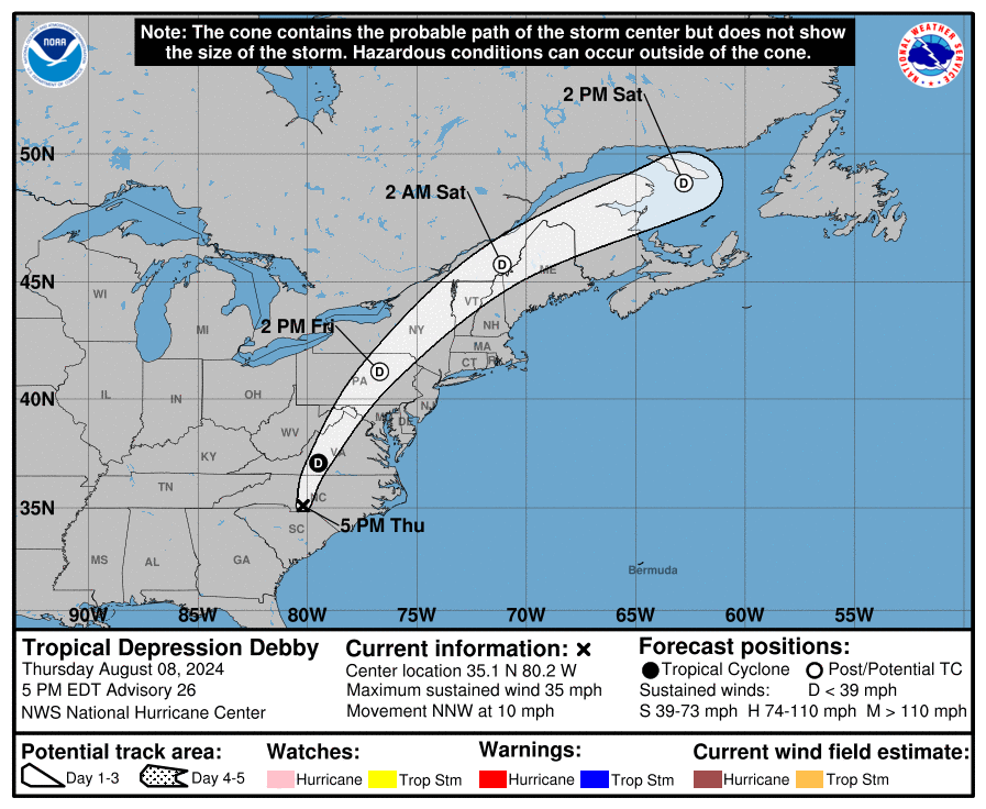
TROPICAL DEPRESSION DEBBY
TROPICAL DEPRESSION DEBBY
Coastal Watches/Warnings and Forecast Cone for Storm Center
* If the storm is forecast to dissipate within 3 days, the “Full Forecast” and “3 day” graphic will be identical
Click Here for a 5-day Cone Printer Friendly Graphic
How to use the cone graphic (video):
About this product:
This graphic shows an approximate representation of coastal areas under a hurricane warning (red), hurricane watch (pink),
tropical storm warning (blue) and tropical storm watch (yellow). The orange circle indicates the current position of the
center of the tropical cyclone. The black line, when selected, and dots show the National Hurricane Center (NHC) forecast track of the center
at the times indicated. The dot indicating the forecast center location will be black if the cyclone is forecast to be
tropical and will be white with a black outline if the cyclone is forecast to be extratropical. If only an L is displayed,
then the system is forecast to be a remnant low. The letter inside the dot indicates the NHC’s forecast intensity for that time:
D: Tropical Depression – wind speed less than 39 MPH
S: Tropical Storm – wind speed between 39 MPH and 73 MPH
H: Hurricane – wind speed between 74 MPH and 110 MPH
M: Major Hurricane – wind speed greater than 110 MPH
NHC tropical cyclone forecast tracks can be in error. This forecast
uncertainty is conveyed by the track forecast “cone”, the solid white
and stippled white areas in the graphic. The solid white area depicts
the track forecast uncertainty for days 1-3 of the forecast, while the
stippled area depicts the uncertainty on days 4-5. Historical data
indicate that the entire 5-day path of the center of the tropical
cyclone will remain within the cone about 60-70% of the time. To
form the cone, a set of imaginary circles are placed along the
forecast track at the 12, 24, 36, 48, 72, 96, and 120 h positions,
where the size of each circle is set so that it encloses 67% of the
previous five years official forecast errors. The cone is then formed
by smoothly connecting the area swept out by the set of circles.
It is also important to realize that a tropical cyclone is not a point. Their
effects can span many hundreds of miles from the center. The area
experiencing hurricane force (one-minute average wind speeds of at least
74 mph) and tropical storm force (one-minute average wind speeds of
39-73 mph) winds can extend well beyond the white areas shown enclosing
the most likely track area of the center. The distribution of hurricane
and tropical storm force winds in this tropical cyclone can be seen in
the Wind History graphic linked above.
Considering the combined forecast uncertainties in track, intensity, and size, the
chances that any particular location will experience winds of 34 kt (tropical storm force),
50 kt, or 64 kt (hurricane force) from this tropical cyclone are presented in
tabular form for selected locations and forecast positions. This information is also presented in
graphical form for the 34 kt, 50 kt,
and 64 kt thresholds.
Note: A detailed definition of the NHC track forecast cone is also available.
Originally Posted at:
NATIONAL HURRICANE CENTER and CENTRAL PACIFIC HURRICANE CENTER
At The NATIONAL OCEANIC AND ATMOSPHERIC ADMINISTRATION
Stay Updated with news.freeptomaineradio.com’s Daily Newsletter
Stay informed! Subscribe to our daily newsletter to receive updates on our latest blog posts directly in your inbox. Don’t let important information get buried by big tech.
Current subscribers:
Post-Tropical Cyclone Emilia Forecast Discussion
344
WTPZ45 KNHC 090244
TCDEP5

Post-Tropical Cyclone Emilia Discussion Number  19
NWS National Hurricane Center Miami FL       EP052024
800 PM PDT Thu Aug 08 2024

Emilia has failed to produce much in the way of organized convection
since the prior burst waned earlier this morning, aside from a small
patch of -50 C cloud tops currently south of the estimated center.
SAB Dvorak classifications have been too weak to classify since this
afternoon, while the TAFB Final-T number is down to 2.0/30-kt which
was constrained from going lower. While there might continue to be
some occasional puffs of convection with Emilia over the next day or
so, the cyclone has crossed the 24 C isotherm and heading towards
even cooler ocean waters, and the chance of a more significant
convective resurgence is low. Thus, Emilia is being declared a 30-kt
post-tropical remnant low this cycle, and this will be the last NHC
advisory.

The system continues to move generally west-northwestward at 290/10
kt. This motion should continue for the next several days followed
by a turn more westward beyond 36 h as the low continues to weaken
and becomes more steered by the low-level trade wind flow. The NHC
track forecast is largely an update of the previous forecast, in
good agreement with the multi-model consensus aids. The latest
forecast now shows the remnant low dissipating after 72 h, a bit
faster than before.


FORECAST POSITIONS AND MAX WINDS

INIT  09/0300Z 22.3N 125.3W   30 KT  35 MPH...POST-TROP/REMNT LOW
 12H  09/1200Z 22.9N 127.0W   30 KT  35 MPH...POST-TROP/REMNT LOW
 24H  10/0000Z 23.5N 129.0W   25 KT  30 MPH...POST-TROP/REMNT LOW
 36H  10/1200Z 24.1N 131.0W   25 KT  30 MPH...POST-TROP/REMNT LOW
 48H  11/0000Z 24.6N 132.7W   20 KT  25 MPH...POST-TROP/REMNT LOW
 60H  11/1200Z 24.8N 134.5W   20 KT  25 MPH...POST-TROP/REMNT LOW
 72H  12/0000Z 24.7N 136.6W   20 KT  25 MPH...POST-TROP/REMNT LOW
 96H  13/0000Z...DISSIPATED

$$
Forecaster Papin
Originally Posted at:
NATIONAL HURRICANE CENTER and CENTRAL PACIFIC HURRICANE CENTER At The NATIONAL OCEANIC AND ATMOSPHERIC ADMINISTRATION
Stay Updated with news.freeptomaineradio.com’s Daily Newsletter
Stay informed! Subscribe to our daily newsletter to receive updates on our latest blog posts directly in your inbox. Don’t let important information get buried by big tech.
Current subscribers:
Post-Tropical Cyclone Emilia Wind Speed Probabilities
000
FOPZ15 KNHC 090242
PWSEP5

POST-TROPICAL CYCLONE EMILIA WIND SPEED PROBABILITIES NUMBER  19
NWS NATIONAL HURRICANE CENTER MIAMI FL       EP052024
0300 UTC FRI AUG 09 2024

AT 0300Z THE CENTER OF POST-TROPICAL CYCLONE EMILIA WAS LOCATED NEAR
LATITUDE 22.3 NORTH...LONGITUDE 125.3 WEST WITH MAXIMUM SUSTAINED
WINDS NEAR 30 KTS...35 MPH...55 KM/H.

Z INDICATES COORDINATED UNIVERSAL TIME (GREENWICH)
   PACIFIC  DAYLIGHT TIME (PDT)...SUBTRACT 7 HOURS FROM Z TIME
   HAWAIIAN STANDARD TIME (HST)...SUBTRACT 10 HOURS FROM Z TIME

WIND SPEED PROBABILITY TABLE FOR SPECIFIC LOCATIONS

CHANCES OF SUSTAINED (1-MINUTE AVERAGE) WIND SPEEDS OF AT LEAST
   ...34 KT (39 MPH... 63 KM/H)...
   ...50 KT (58 MPH... 93 KM/H)...
   ...64 KT (74 MPH...119 KM/H)...
FOR LOCATIONS AND TIME PERIODS DURING THE NEXT 5 DAYS

PROBABILITIES FOR LOCATIONS ARE GIVEN AS OP(CP) WHERE
    OP  IS THE PROBABILITY OF THE EVENT BEGINNING DURING
        AN INDIVIDUAL TIME PERIOD (ONSET PROBABILITY)
   (CP) IS THE PROBABILITY OF THE EVENT OCCURRING BETWEEN
        00Z FRI AND THE FORECAST HOUR (CUMULATIVE PROBABILITY)

PROBABILITIES ARE GIVEN IN PERCENT
X INDICATES PROBABILITIES LESS THAN 1 PERCENT
PROBABILITIES FOR 34 KT AND 50 KT ARE SHOWN AT A GIVEN LOCATION WHEN
THE 5-DAY CUMULATIVE PROBABILITY IS AT LEAST 3 PERCENT.
PROBABILITIES FOR 34...50...64 KT SHOWN WHEN THE 5-DAY
64-KT CUMULATIVE PROBABILITY IS AT LEAST 1 PERCENT.


  - - - - WIND SPEED PROBABILITIES FOR SELECTED LOCATIONS - - - -

               FROM    FROM    FROM    FROM    FROM    FROM    FROM
  TIME       00Z FRI 12Z FRI 00Z SAT 12Z SAT 00Z SUN 00Z MON 00Z TUE
PERIODS         TO      TO      TO      TO      TO      TO      TO
             12Z FRI 00Z SAT 12Z SAT 00Z SUN 00Z MON 00Z TUE 00Z WED

FORECAST HOUR    (12)   (24)    (36)    (48)    (72)    (96)   (120)
- - - - - - - - - - - - - - - - - - - - - - - - - - - - - - - - - -
LOCATION       KT

25N 130W       34  X   2( 2)   3( 5)   X( 5)   X( 5)   X( 5)   X( 5)

25N 135W       34  X   X( X)   X( X)   1( 1)   5( 6)   X( 6)   X( 6)

$$
FORECASTER PAPIN
Originally Posted at:
NATIONAL HURRICANE CENTER and CENTRAL PACIFIC HURRICANE CENTER At The NATIONAL OCEANIC AND ATMOSPHERIC ADMINISTRATION
Stay Updated with news.freeptomaineradio.com’s Daily Newsletter
Stay informed! Subscribe to our daily newsletter to receive updates on our latest blog posts directly in your inbox. Don’t let important information get buried by big tech.
Current subscribers:

POST-TROPICAL CYCLONE EMILIA
POST-TROPICAL CYCLONE EMILIA
Coastal Watches/Warnings and Forecast Cone for Storm Center
* If the storm is forecast to dissipate within 3 days, the “Full Forecast” and “3 day” graphic will be identical
Click Here for a 5-day Cone Printer Friendly Graphic
How to use the cone graphic (video):
About this product:
This graphic shows an approximate representation of coastal areas under a hurricane warning (red), hurricane watch (pink),
tropical storm warning (blue) and tropical storm watch (yellow). The orange circle indicates the current position of the
center of the tropical cyclone. The black line, when selected, and dots show the National Hurricane Center (NHC) forecast track of the center
at the times indicated. The dot indicating the forecast center location will be black if the cyclone is forecast to be
tropical and will be white with a black outline if the cyclone is forecast to be extratropical. If only an L is displayed,
then the system is forecast to be a remnant low. The letter inside the dot indicates the NHC’s forecast intensity for that time:
D: Tropical Depression – wind speed less than 39 MPH
S: Tropical Storm – wind speed between 39 MPH and 73 MPH
H: Hurricane – wind speed between 74 MPH and 110 MPH
M: Major Hurricane – wind speed greater than 110 MPH
NHC tropical cyclone forecast tracks can be in error. This forecast
uncertainty is conveyed by the track forecast “cone”, the solid white
and stippled white areas in the graphic. The solid white area depicts
the track forecast uncertainty for days 1-3 of the forecast, while the
stippled area depicts the uncertainty on days 4-5. Historical data
indicate that the entire 5-day path of the center of the tropical
cyclone will remain within the cone about 60-70% of the time. To
form the cone, a set of imaginary circles are placed along the
forecast track at the 12, 24, 36, 48, 72, 96, and 120 h positions,
where the size of each circle is set so that it encloses 67% of the
previous five years official forecast errors. The cone is then formed
by smoothly connecting the area swept out by the set of circles.
It is also important to realize that a tropical cyclone is not a point. Their
effects can span many hundreds of miles from the center. The area
experiencing hurricane force (one-minute average wind speeds of at least
74 mph) and tropical storm force (one-minute average wind speeds of
39-73 mph) winds can extend well beyond the white areas shown enclosing
the most likely track area of the center. The distribution of hurricane
and tropical storm force winds in this tropical cyclone can be seen in
the Wind History graphic linked above.
Considering the combined forecast uncertainties in track, intensity, and size, the
chances that any particular location will experience winds of 34 kt (tropical storm force),
50 kt, or 64 kt (hurricane force) from this tropical cyclone are presented in
tabular form for selected locations and forecast positions. This information is also presented in
graphical form for the 34 kt, 50 kt,
and 64 kt thresholds.
Note: A detailed definition of the NHC track forecast cone is also available.
Originally Posted at:
NATIONAL HURRICANE CENTER and CENTRAL PACIFIC HURRICANE CENTER
At The NATIONAL OCEANIC AND ATMOSPHERIC ADMINISTRATION
Stay Updated with news.freeptomaineradio.com’s Daily Newsletter
Stay informed! Subscribe to our daily newsletter to receive updates on our latest blog posts directly in your inbox. Don’t let important information get buried by big tech.
Current subscribers:
Tropical Depression Debby Public Advisory
723
WTNT34 KWNH 090242
TCPAT4

BULLETIN
Tropical Depression Debby Advisory Number  27
NWS Weather Prediction Center College Park MD   AL042024
1100 PM EDT Thu Aug 08 2024

...MAJOR FLOOD THREAT CONTINUES FOR PORTIONS OF WESTERN VIRGINIA...


SUMMARY OF 1100 PM EDT...0300 UTC...INFORMATION
-----------------------------------------------
LOCATION...36.2N 80.2W
ABOUT 80 MI...135 KM NNE OF CHARLOTTE NORTH CAROLINA
ABOUT 90 MI...140 KM WNW OF RALEIGH NORTH CAROLINA
MAXIMUM SUSTAINED WINDS...30 MPH...45 KM/H
PRESENT MOVEMENT...NNE OR 20 DEGREES AT 26 MPH...43 KM/H
MINIMUM CENTRAL PRESSURE...1001 MB...29.56 INCHES


WATCHES AND WARNINGS
--------------------
SUMMARY OF WATCHES AND WARNINGS IN EFFECT:

Flood Watches and Warnings are in effect for portions of....
* South Carolina
* North Carolina
* Virginia
* Eastern West Virginia
* Maryland
* Pennsylvania

A Flood Watch is in effect for portions of...
* Upstate New York
* Northern Vermont
* Northern New Hampshire

A Tornado Watch is in effect for portions of...
* Eastern North Carolina
* Northern and Eastern Virginia
* Maryland
* District of Columbia
* Eastern West Virginia

Coastal Flood Advisories are in effect for portions of...
* Eastern North Carolina
* Areas surrounding the Chesapeake Bay and Potomac River
* Central New Jersey Coast

A Gale Watch is in effect the coastal waters of...
* Rhode Island
* Southeastern Massachusetts up through Cape Cod

Wind Advisories are in effect for portions of...
* Western Virginia
* Eastern Maryland
* Delaware
* Eastern Pennsylvania
* New Jersey
* Southern New York
* Southern Connecticut


DISCUSSION AND OUTLOOK
----------------------
At 1100 PM EDT (0300 UTC), the center of Tropical Depression Debby
was located near latitude 36.2 North, longitude 80.2 West. The
depression is moving toward the north-northeast near 26 mph (43
km/h) and this motion is expected to slowly increase and shift to
the northeast over the next day.

Maximum sustained winds are near 30 mph (45 km/h) with higher gusts.
Little change in strength is forecast during the next 48 hours.

The estimated minimum central pressure is 1001 mb (29.56 inches).


HAZARDS AFFECTING LAND
----------------------
Key messages for Debby can be found in the Tropical Cyclone
Discussion under AWIPS header MIATCDAT4 and WMO header WTNT44 KNHC.

RAINFALL: Debby is expected to produce an additional 3 to 6 inches
of rainfall with locally higher amounts, across portions of
southeastern North Carolina leading to maximum storm total amounts
as high as 15 inches.  Additional rainfall of 1 to 3 inches over
portions of eastern South Carolina will bring maximum storm total
amounts as high as 20 to 25 inches. Considerable flooding is
expected across portions of eastern South Carolina and southeast
North Carolina through Friday.

From central North Carolina northward across portions of Virginia, 3
to 7 inches with local amounts to 10 inches, are expected through
Friday. This rainfall will likely result in areas of considerable to
locally catastrophic flash and urban flooding, especially in the
terrain of western Virginia, with river flooding also possible.

From portions of Maryland north through Upstate New York and
Vermont, 2 to 4 inches, with local amounts to 6 inches, are expected
through Friday night. This will likely result in areas of
considerable flash and urban flooding as well as river flooding.

For the remainder of northern New England, 1 to 3 inches, with
local amounts to 4 inches, are expected into Saturday.  Scattered
instances of flash flooding are possible.

For a complete depiction of forecast rainfall and flash flooding
associated with  Debby, please see the National Weather Service
Storm Total Rainfall Graphic, available at
hurricanes.gov/graphics_at4.shtml?rainqpf and the Flash Flood Risk
graphic at hurricanes.gov/graphics_at4.shtml?ero.  For a list of
rainfall observations (and wind reports) associated this storm, see
the companion storm summary at WBCSCCNS4 with the WMO header ACUS44
KWBC or at the following link:
www.wpc.ncep.noaa.gov/discussions/nfdscc4.html.

TORNADOES: A few tornadoes may occur tonight from eastern North
Carolina into Virginia and Maryland. The threat for tornadoes will
shift northward into parts of New Jersey, eastern Pennsylvania and
southeast New York on Friday.

SURF:  Large swells will continue to affect the Southeast and the
Mid Atlantic coast for another day or so. These conditions are
likely to cause life-threatening surf and rip current conditions.
Please consult products from your local weather office.


NEXT ADVISORY
-------------
Next complete advisory at 500 AM EDT.

$$
Forecaster Pereira/Gallina/Chenard
Originally Posted at:
NATIONAL HURRICANE CENTER and CENTRAL PACIFIC HURRICANE CENTER
At The NATIONAL OCEANIC AND ATMOSPHERIC ADMINISTRATION
Stay Updated with news.freeptomaineradio.com’s Daily Newsletter
Stay informed! Subscribe to our daily newsletter to receive updates on our latest blog posts directly in your inbox. Don’t let important information get buried by big tech.
Current subscribers: