


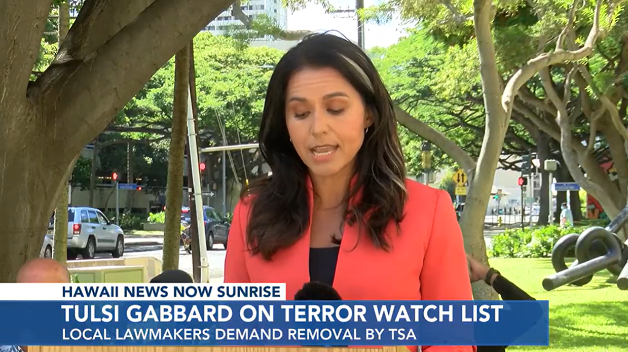
TSA Puts Tulsi Gabbard on “Quiet Skies” Terrorist Watchlist
by Mish Shedlock, Mish Talk:
When I first saw this headline I thought it was a spoof. It’s political retribution, not a spoof.
This came the day after Gabbard criticized the Biden Administration according to the video above.
Please note Lawmakers incensed after former congresswoman placed on terror watch list
Representatives Gene Ward, Diamond Garcia, Davis Alcos and Elijah Pierick sent a letter to the Transportation Security Administration (TSA) asking for answers and calling the move “harassment.”
TRUTH LIVES on at https://sgtreport.tv/
The Air Marshal National Council says whistle-blowers told them that Gabbard is included in the Quiet Skies program, which monitors “elevated risks to aviation security.”
Rep. Burchett Demands Answers from TSA
On his website Rep. Rep. Burchett Demands Answers from TSA
Here is Burchett’s Letter to the TSA.
I write to you today regarding a report concerning former Congresswoman and presidential candidate, Tulsi Gabbard. I have been told Mrs. Gabbard has been placed on a Transportation Security Administration (TSA) watchlist under a program known as “Quiet Skies”.
I find this profoundly troubling for a number of reasons.
I request a meeting with either yourself or the individual at TSA in charge of overseeing the Quiet Skies program. Please reach out to my office to schedule this meeting. Your expeditious response is appreciated.
‘Stress’ from Life Under Surveillance
The Gazette comments Tulsi Gabbard Details ‘Stress’ from Life Under Surveillance
Former Hawaii Rep. Tulsi Gabbard said she and her family are stressed due to increased levels of surveillance after whistleblowers reported multiple air marshals have been on flights with the former congresswoman.
“This is only the information that we know. Obviously, I experienced a significant change in my travel when all of this began on July 23,” Gabbard said on Fox News’s Hannity.
“My real question is, what don’t I know?” she said.
“Given this environment, it’s impossible to feel free,” Gabbard said. “No American deserves this. No American deserves to live in fear of our own government.”
“We know under the Biden-Harris administration, they have no hesitation in weaponizing all means possible, all tools available to them, to target and go after their political opponents, anyone they deem as a threat to their power,” she added.
Originally Posted at https://www.sgtreport.com
Stay Updated with news.freeptomaineradio.com’s Daily Newsletter
Stay informed! Subscribe to our daily newsletter to receive updates on our latest blog posts directly in your inbox. Don’t let important information get buried by big tech.
Current subscribers:

Squad Member Ilhan Omar Wins Reelection in Primary Race
Squad member Rep. Ilhan Omar (R-MN) won her primary race for Minnesota’s 5th Congressional District on Tuesday evening.
Omar received 67,524 votes, or 56.2 percent of the vote, while Don Samuels, a former member of the Minneapolis City Council, received 51,581 votes, or 42.9 percent of the vote, according to the Associated Press (AP).
Another candidate, Abena McKenzie, received 456 votes, or 0.4 percent of the vote, while opponent Nate Schluter received votes 567, or 0.5 percent of the vote.
The Associated Press called the race at 10:39 p.m.
Omar’s win comes after two other Squad members, Rep. Cori Bush (D-MO) and Rep. Jamaal Bowman (D-NY) lost their primary races.
The Minnesota congresswoman previously narrowly defeated Samuels in the last election cycle. Samuels ended up losing by just over two percent of the vote and received 48.2 percent, while Omar received 50.3 percent.
A poll conducted by Lake Research Partners in July found that Omar had a “sizable lead over Samuels” of 27 points, with Omar receiving 60 percent of support, while Samuels led by 33 percent, according to Newsweek. This poll was conducted on behalf of Omar’s campaign.
Another poll conducted in February by Victoria Research & Consulting, this time on behalf of Samuels campaign, found that Omar received 49 percent of support, while Samuels received 30 percent of support, according to the outlet.
Omar has faced criticism regarding her anti-Israel views. Omar, along with fellow Squad members Bowman and Rep. Alexandria Ocasio-Cortez (D-NY), are facing a class-action lawsuit and have been accused of “inciting and encouraging” the anti-Israel protests and encampment that occurred at Columbia University in the spring.
The congresswoman has also supported the withholding of artillery and other weapons to Israel.
In February 2023, Omar was ousted from her position on the Foreign Affairs Committee due to her previous derogatory remarks about Jewish people.
Omar will face Republican candidate Dalia Al-Aqidi in November.
Originally Posted At www.breitbart.com
Stay Updated with news.freeptomaineradio.com’s Daily Newsletter
Stay informed! Subscribe to our daily newsletter to receive updates on our latest blog posts directly in your inbox. Don’t let important information get buried by big tech.
Current subscribers:
Tropical Storm Ernesto Forecast Discussion
733
WTNT45 KNHC 140247
TCDAT5

Tropical Storm Ernesto Discussion Number  10
NWS National Hurricane Center Miami FL       AL052024
1100 PM AST Tue Aug 13 2024

Aircraft data, surface observations, and NWS radar images indicate
Ernesto passed over the Virgin Islands around 00 UTC this evening.
The tropical cyclone remains asymmetric, as NOAA Tail Doppler Radar
data show the strongest winds and heaviest rainfall are generally
confined to the northern and eastern semicircles of the storm. Data
from the NOAA and Air Force Hurricane Hunters indicate the central
pressure of Ernesto has fallen to around 998-999 mb, and an earlier
aircraft pass through the eastern part of the storm found peak
700-mb flight-level winds of 60 kt. Based on these data, the initial
intensity is set at 55 kt, which matches the latest Dvorak current
intensity estimates from TAFB and SAB.

The latest aircraft fixes and radar data show Ernesto has turned
northwestward (305/15 kt). Overnight, Ernesto will move away from
the Virgin Islands and pass to the northeast and north of Puerto
Rico. Then, Ernesto is expected to move northwestward to northward
during the next couple of days toward a break in the subtropical
ridge. By late week, the influence of a deep-layer trough over the
western Atlantic should cause Ernesto to turn north-northeastward,
although the cyclone is forecast to slow down a bit after the trough
passes to its north. There are no notable changes to the NHC track
forecast, with Ernesto forecast to make its closest approach to
Bermuda Friday night into Saturday.

The radar structure of Ernesto indicates it has not yet solidified
an inner core. However, once this occurs, the atmospheric and
oceanic conditions appear conducive for significant strengthening
over the next few days. Most of the hurricane regional models and
statistical guidance show Ernesto becoming a major hurricane over
the western Atlantic late this week, and the global models
(particularly the GFS) show significant deepening of the low. Based
on the latest guidance trends, the NHC intensity forecast has been
raised slightly during the middle portion of the forecast period and
now shows Ernesto becoming a major hurricane on Friday.


Key Messages:

1. Tropical storm conditions are expected to continue over the
Virgin Islands and Puerto Rico through early Wednesday, with
hurricane conditions possible on the Virgin Islands, Culebra, and
Vieques.

2. Heavy rainfall may result in locally considerable flash flooding
and mudslides over the Virgin Islands and into portions of Puerto
Rico tonight through Wednesday.

3. Ernesto is likely to bring impacts to Bermuda late this week,
and interests there should monitor the progress of this system.

4. Swells generated by Ernesto are expected to affect portions of
the Virgin Islands, Puerto Rico, the Dominican Republic, the Turks
and Caicos, and the Bahamas during the next few days, and then reach
the east coast of the United States and Bermuda late this week and
into the weekend. These swells are likely to cause life-threatening
surf and rip current conditions.


FORECAST POSITIONS AND MAX WINDS

INIT  14/0300Z 18.8N  65.3W   55 KT  65 MPH
 12H  14/1200Z 20.3N  66.7W   65 KT  75 MPH
 24H  15/0000Z 22.4N  68.3W   80 KT  90 MPH
 36H  15/1200Z 24.4N  68.8W   90 KT 105 MPH
 48H  16/0000Z 26.3N  68.3W   95 KT 110 MPH
 60H  16/1200Z 28.1N  67.2W  100 KT 115 MPH
 72H  17/0000Z 29.9N  66.2W  100 KT 115 MPH
 96H  18/0000Z 34.0N  64.5W   90 KT 105 MPH
120H  19/0000Z 38.0N  63.0W   85 KT 100 MPH

$$
Forecaster Reinhart
Originally Posted at:
NATIONAL HURRICANE CENTER and CENTRAL PACIFIC HURRICANE CENTER
At The NATIONAL OCEANIC AND ATMOSPHERIC ADMINISTRATION
Stay Updated with news.freeptomaineradio.com’s Daily Newsletter
Stay informed! Subscribe to our daily newsletter to receive updates on our latest blog posts directly in your inbox. Don’t let important information get buried by big tech.
Current subscribers:
Tropical Storm Ernesto Wind Speed Probabilities
945
FONT15 KNHC 140246
PWSAT5

TROPICAL STORM ERNESTO WIND SPEED PROBABILITIES NUMBER  10
NWS NATIONAL HURRICANE CENTER MIAMI FL       AL052024
0300 UTC WED AUG 14 2024

AT 0300Z THE CENTER OF TROPICAL STORM ERNESTO WAS LOCATED NEAR
LATITUDE 18.8 NORTH...LONGITUDE 65.3 WEST WITH MAXIMUM SUSTAINED
WINDS NEAR 55 KTS...65 MPH...100 KM/H.

Z INDICATES COORDINATED UNIVERSAL TIME (GREENWICH)
   ATLANTIC STANDARD TIME (AST)...SUBTRACT 4 HOURS FROM Z TIME
   EASTERN  DAYLIGHT TIME (EDT)...SUBTRACT 4 HOURS FROM Z TIME
   CENTRAL  DAYLIGHT TIME (CDT)...SUBTRACT 5 HOURS FROM Z TIME

WIND SPEED PROBABILITY TABLE FOR SPECIFIC LOCATIONS

CHANCES OF SUSTAINED (1-MINUTE AVERAGE) WIND SPEEDS OF AT LEAST
   ...34 KT (39 MPH... 63 KM/H)...
   ...50 KT (58 MPH... 93 KM/H)...
   ...64 KT (74 MPH...119 KM/H)...
FOR LOCATIONS AND TIME PERIODS DURING THE NEXT 5 DAYS

PROBABILITIES FOR LOCATIONS ARE GIVEN AS OP(CP) WHERE
    OP  IS THE PROBABILITY OF THE EVENT BEGINNING DURING
        AN INDIVIDUAL TIME PERIOD (ONSET PROBABILITY)
   (CP) IS THE PROBABILITY OF THE EVENT OCCURRING BETWEEN
        00Z WED AND THE FORECAST HOUR (CUMULATIVE PROBABILITY)

PROBABILITIES ARE GIVEN IN PERCENT
X INDICATES PROBABILITIES LESS THAN 1 PERCENT
PROBABILITIES FOR 34 KT AND 50 KT ARE SHOWN AT A GIVEN LOCATION WHEN
THE 5-DAY CUMULATIVE PROBABILITY IS AT LEAST 3 PERCENT.
PROBABILITIES FOR 34...50...64 KT SHOWN WHEN THE 5-DAY
64-KT CUMULATIVE PROBABILITY IS AT LEAST 1 PERCENT.


  - - - - WIND SPEED PROBABILITIES FOR SELECTED LOCATIONS - - - -

               FROM    FROM    FROM    FROM    FROM    FROM    FROM
  TIME       00Z WED 12Z WED 00Z THU 12Z THU 00Z FRI 00Z SAT 00Z SUN
PERIODS         TO      TO      TO      TO      TO      TO      TO
             12Z WED 00Z THU 12Z THU 00Z FRI 00Z SAT 00Z SUN 00Z MON

FORECAST HOUR    (12)   (24)    (36)    (48)    (72)    (96)   (120)
- - - - - - - - - - - - - - - - - - - - - - - - - - - - - - - - - -
LOCATION       KT

ILE ST PIERRE  34  X   X( X)   X( X)   X( X)   X( X)   X( X)   3( 3)

BURGEO NFLD    34  X   X( X)   X( X)   X( X)   X( X)   X( X)   3( 3)

PTX BASQUES    34  X   X( X)   X( X)   X( X)   X( X)   X( X)   3( 3)

EDDY POINT NS  34  X   X( X)   X( X)   X( X)   X( X)   X( X)   7( 7)
EDDY POINT NS  50  X   X( X)   X( X)   X( X)   X( X)   X( X)   2( 2)
EDDY POINT NS  64  X   X( X)   X( X)   X( X)   X( X)   X( X)   1( 1)

SYDNEY NS      34  X   X( X)   X( X)   X( X)   X( X)   X( X)   5( 5)

SABLE ISLAND   34  X   X( X)   X( X)   X( X)   X( X)   X( X)  12(12)
SABLE ISLAND   50  X   X( X)   X( X)   X( X)   X( X)   X( X)   4( 4)
SABLE ISLAND   64  X   X( X)   X( X)   X( X)   X( X)   X( X)   2( 2)

HALIFAX NS     34  X   X( X)   X( X)   X( X)   X( X)   X( X)   4( 4)

YARMOUTH NS    34  X   X( X)   X( X)   X( X)   X( X)   X( X)   8( 8)
YARMOUTH NS    50  X   X( X)   X( X)   X( X)   X( X)   X( X)   2( 2)
YARMOUTH NS    64  X   X( X)   X( X)   X( X)   X( X)   X( X)   1( 1)

ST JOHN NB     34  X   X( X)   X( X)   X( X)   X( X)   X( X)   4( 4)

EASTPORT ME    34  X   X( X)   X( X)   X( X)   X( X)   X( X)   4( 4)

HYANNIS MA     34  X   X( X)   X( X)   X( X)   X( X)   X( X)   3( 3)

NANTUCKET MA   34  X   X( X)   X( X)   X( X)   X( X)   X( X)   6( 6)

PROVIDENCE RI  34  X   X( X)   X( X)   X( X)   X( X)   X( X)   3( 3)

BERMUDA        34  X   X( X)   X( X)   X( X)  37(37)  40(77)   5(82)
BERMUDA        50  X   X( X)   X( X)   X( X)  10(10)  34(44)   4(48)
BERMUDA        64  X   X( X)   X( X)   X( X)   5( 5)  20(25)   3(28)

SAN SALVADOR   34  X   X( X)   2( 2)   X( 2)   1( 3)   X( 3)   X( 3)

MAYAGUANA      34  X   4( 4)   3( 7)   1( 8)   X( 8)   X( 8)   X( 8)

GRAND TURK     34  1   5( 6)   3( 9)   2(11)   X(11)   X(11)   1(12)

PUERTO PLATA   34  1   4( 5)   3( 8)   X( 8)   X( 8)   X( 8)   X( 8)

SANTO DOMINGO  34  1   4( 5)   X( 5)   X( 5)   X( 5)   X( 5)   X( 5)

PONCE PR       34  4   3( 7)   X( 7)   X( 7)   X( 7)   X( 7)   X( 7)

AGUADILLA PR   34  5   3( 8)   1( 9)   X( 9)   X( 9)   X( 9)   X( 9)

SAN JUAN PR    34  6   2( 8)   X( 8)   X( 8)   X( 8)   X( 8)   X( 8)

VIEQUES PR     34 27   1(28)   X(28)   X(28)   X(28)   X(28)   X(28)

SAINT THOMAS   34 99   X(99)   X(99)   X(99)   X(99)   X(99)   X(99)
SAINT THOMAS   50  5   X( 5)   X( 5)   X( 5)   X( 5)   X( 5)   X( 5)

SAINT JOHN     34 99   X(99)   X(99)   X(99)   X(99)   X(99)   X(99)
SAINT JOHN     50 34   X(34)   X(34)   X(34)   X(34)   X(34)   X(34)

SAINT CROIX    34 11   2(13)   X(13)   X(13)   X(13)   X(13)   X(13)

SAINT MAARTEN  34  3   1( 4)   X( 4)   X( 4)   X( 4)   X( 4)   X( 4)

SABA           34  3   X( 3)   X( 3)   X( 3)   X( 3)   X( 3)   X( 3)

ST EUSTATIUS   34  3   X( 3)   X( 3)   X( 3)   X( 3)   X( 3)   X( 3)

$$
FORECASTER REINHART
Originally Posted at:
NATIONAL HURRICANE CENTER and CENTRAL PACIFIC HURRICANE CENTER
At The NATIONAL OCEANIC AND ATMOSPHERIC ADMINISTRATION
Stay Updated with news.freeptomaineradio.com’s Daily Newsletter
Stay informed! Subscribe to our daily newsletter to receive updates on our latest blog posts directly in your inbox. Don’t let important information get buried by big tech.
Current subscribers:
Tropical Storm Ernesto Public Advisory
566
WTNT35 KNHC 140245
TCPAT5

BULLETIN
Tropical Storm Ernesto Advisory Number  10
NWS National Hurricane Center Miami FL       AL052024
1100 PM AST Tue Aug 13 2024

...ERNESTO EXPECTED TO STRENGTHEN WHILE IT PASSES NORTHEAST OF
PUERTO RICO OVERNIGHT...


SUMMARY OF 1100 PM AST...0300 UTC...INFORMATION
-----------------------------------------------
LOCATION...18.8N 65.3W
ABOUT 35 MI...55 KM NW OF ST. THOMAS
ABOUT 60 MI...95 KM ENE OF SAN JUAN PUERTO RICO
MAXIMUM SUSTAINED WINDS...65 MPH...100 KM/H
PRESENT MOVEMENT...NW OR 305 DEGREES AT 17 MPH...28 KM/H
MINIMUM CENTRAL PRESSURE...998 MB...29.47 INCHES


WATCHES AND WARNINGS
--------------------
CHANGES WITH THIS ADVISORY:

None.

SUMMARY OF WATCHES AND WARNINGS IN EFFECT:

A Hurricane Watch is in effect for...
* U.S. Virgin Islands
* British Virgin Islands
* Vieques and Culebra

A Tropical Storm Warning is in effect for...
* British Virgin Islands
* U.S. Virgin Islands
* Puerto Rico
* Vieques and Culebra

A Hurricane Watch means that hurricane conditions are possible
within the watch area, in this case through tonight.

A Tropical Storm Warning means that tropical storm conditions are
expected somewhere within the warning area within 36 hours.

Interests in Bermuda should monitor the progress of Ernesto.

For storm information specific to your area in the United
States, including possible inland watches and warnings, please
monitor products issued by your local National Weather Service
forecast office. For storm information specific to your area
outside of the United States, please monitor products issued by
your national meteorological service.


DISCUSSION AND OUTLOOK
----------------------
At 1100 PM AST (0300 UTC), the center of Tropical Storm Ernesto was
located near latitude 18.8 North, longitude 65.3 West. Ernesto is
moving toward the northwest near 17 mph (28 km/h). A turn toward the
north-northwest and north with a gradual decrease in forward speed
is expected on Wednesday night and Thursday. On the forecast track,
the center of Ernesto will pass to the northeast and north of Puerto
Rico through early Wednesday. Ernesto should then move over the
western Atlantic later in the week and approach Bermuda on Friday
and Friday night.

Maximum sustained winds are near 65 mph (100 km/h) with higher
gusts. Strengthening is forecast during the next several days, and
Ernesto is expected to become a hurricane by early Wednesday to the
north of the Virgin Islands and Puerto Rico.

Tropical-storm-force winds extend outward up to 125 miles (205 km)
from the center. Henry E. Rohlsen Airport in St. Croix recently
reported a sustained wind of 36 mph (57 km/h) and a gust of 58 mph
(93 km/h).

The estimated minimum central pressure is 998 mb (29.47 inches).


HAZARDS AFFECTING LAND
----------------------
Key messages for Ernesto can be found in the Tropical Cyclone
Discussion under AWIPS header MIATCDAT5 and WMO header WTNT45 KNHC
and on the web at hurricanes.gov/text/MIATCDAT5.shtml.

RAINFALL: Ernesto is expected to produce total rain accumulations of
4 to 6 inches over the U.S and British Virgin Islands. Rainfall
totals of 6 to 8 inches, with maximum amounts of 10 inches, are
expected across southeastern Puerto Rico, with totals of 2 to 4
inches across northwestern Puerto Rico.

For a complete depiction of forecast rainfall associated with
Ernesto, please see the National Weather Service Storm Total
Rainfall Graphic, available at
hurricanes.gov/graphics_at5.shtml?rainqpf

WIND: Tropical storm conditions will continue spreading across the
Virgin Islands, Puerto Rico, Vieques, and Culebra through the
overnight hours. Hurricane conditions are possible in portions of
the watch area during the next several hours.

STORM SURGE: A storm surge will raise water levels by as much as 1
to 3 feet above ground level for the eastern coast of Puerto Rico
from San Juan to Guayama, including the islands of Culebra and
Vieques and in the U.S. Virgin Islands, including St. Thomas, St.
John, and St. Croix.

A storm surge will raise water levels by as much as 1 to 3 feet
above normal tide levels in the British Virgin Islands. Near the
coast, the surge will be accompanied by large and destructive waves.

SURF: Swells generated by Ernesto are affecting portions of the
Leeward Islands, the Virgin Islands, and Puerto Rico. These swells
will reach the Dominican Republic overnight, the Turks and Caicos
Islands and southeastern Bahamas on Wednesday, and Bermuda and the
rest of the Bahamas on Thursday. Swells are expected to reach the
east coast of the United States Thursday night and continue into the
weekend. These swells are likely to cause life-threatening surf and
rip current conditions. Please consult products from your local
weather office.


NEXT ADVISORY
-------------
Next intermediate advisory at 200 AM AST.
Next complete advisory at 500 AM AST.

$$
Forecaster Reinhart
Originally Posted at:
NATIONAL HURRICANE CENTER and CENTRAL PACIFIC HURRICANE CENTER
At The NATIONAL OCEANIC AND ATMOSPHERIC ADMINISTRATION
Stay Updated with news.freeptomaineradio.com’s Daily Newsletter
Stay informed! Subscribe to our daily newsletter to receive updates on our latest blog posts directly in your inbox. Don’t let important information get buried by big tech.
Current subscribers:
Tropical Storm Ernesto Forecast Advisory
000
WTNT25 KNHC 140245
TCMAT5

TROPICAL STORM ERNESTO FORECAST/ADVISORY NUMBER  10
NWS NATIONAL HURRICANE CENTER MIAMI FL       AL052024
0300 UTC WED AUG 14 2024

TROPICAL STORM CENTER LOCATED NEAR 18.8N  65.3W AT 14/0300Z
POSITION ACCURATE WITHIN  30 NM

PRESENT MOVEMENT TOWARD THE NORTHWEST OR 305 DEGREES AT  15 KT

ESTIMATED MINIMUM CENTRAL PRESSURE  998 MB
MAX SUSTAINED WINDS  55 KT WITH GUSTS TO  65 KT.
50 KT....... 40NE   0SE   0SW   0NW.
34 KT.......110NE 100SE   0SW  70NW.
12 FT SEAS..180NE 120SE   0SW 120NW.
WINDS AND SEAS VARY GREATLY IN EACH QUADRANT.  RADII IN NAUTICAL
MILES ARE THE LARGEST RADII EXPECTED ANYWHERE IN THAT QUADRANT.

REPEAT...CENTER LOCATED NEAR 18.8N  65.3W AT 14/0300Z
AT 14/0000Z CENTER WAS LOCATED NEAR 18.4N  64.7W

FORECAST VALID 14/1200Z 20.3N  66.7W
MAX WIND  65 KT...GUSTS  80 KT.
64 KT... 20NE  10SE   0SW   0NW.
50 KT... 60NE  30SE   0SW  30NW.
34 KT...140NE 130SE  40SW 110NW.

FORECAST VALID 15/0000Z 22.4N  68.3W
MAX WIND  80 KT...GUSTS 100 KT.
64 KT... 25NE  15SE   0SW  10NW.
50 KT... 70NE  50SE  20SW  30NW.
34 KT...150NE 150SE  70SW 120NW.

FORECAST VALID 15/1200Z 24.4N  68.8W
MAX WIND  90 KT...GUSTS 110 KT.
64 KT... 35NE  30SE  10SW  15NW.
50 KT... 80NE  80SE  40SW  50NW.
34 KT...160NE 160SE  90SW 120NW.

FORECAST VALID 16/0000Z 26.3N  68.3W
MAX WIND  95 KT...GUSTS 115 KT.
64 KT... 45NE  50SE  25SW  30NW.
50 KT... 90NE  90SE  60SW  50NW.
34 KT...160NE 160SE 110SW 120NW.

FORECAST VALID 16/1200Z 28.1N  67.2W
MAX WIND 100 KT...GUSTS 120 KT.
50 KT... 90NE  90SE  60SW  50NW.
34 KT...160NE 160SE 130SW 110NW.

FORECAST VALID 17/0000Z 29.9N  66.2W
MAX WIND 100 KT...GUSTS 120 KT.
50 KT... 90NE 100SE  60SW  60NW.
34 KT...170NE 170SE 130SW 120NW.

EXTENDED OUTLOOK. NOTE...ERRORS FOR TRACK HAVE AVERAGED NEAR 125 NM
ON DAY 4 AND 175 NM ON DAY 5...AND FOR INTENSITY NEAR 15 KT EACH DAY

OUTLOOK VALID 18/0000Z 34.0N  64.5W
MAX WIND  90 KT...GUSTS 110 KT.
50 KT... 90NE  90SE  60SW  60NW.
34 KT...170NE 180SE 120SW 130NW.

OUTLOOK VALID 19/0000Z 38.0N  63.0W
MAX WIND  85 KT...GUSTS 105 KT.
50 KT... 90NE  90SE  70SW  80NW.
34 KT...180NE 180SE 120SW 130NW.

REQUEST FOR 3 HOURLY SHIP REPORTS WITHIN 300 MILES OF 18.8N  65.3W

INTERMEDIATE PUBLIC ADVISORY...WTNT35 KNHC/MIATCPAT5...AT 14/0600Z

NEXT ADVISORY AT 14/0900Z

$$
FORECASTER REINHART
Originally Posted at:
NATIONAL HURRICANE CENTER and CENTRAL PACIFIC HURRICANE CENTER
At The NATIONAL OCEANIC AND ATMOSPHERIC ADMINISTRATION
Stay Updated with news.freeptomaineradio.com’s Daily Newsletter
Stay informed! Subscribe to our daily newsletter to receive updates on our latest blog posts directly in your inbox. Don’t let important information get buried by big tech.
Current subscribers:

Tropical Storm Ernesto Public Advisory
000
WTNT35 KNHC 132350
TCPAT5
BULLETIN
Tropical Storm Ernesto Intermediate Advisory Number 9A
NATIONAL WEATHER SERVICE, National Hurricane Center Miami Florida AL052024
8:00 P.M. Atlantic Standard Time Tue Aug 13 2024
- ERNESTO MOVING OVER THE VIRGIN ISLANDS
- EXPECTED TO BECOME A HURRICANE OVERNIGHT WHILE PASSING NORTHEAST OF PUERTO RICO
SUMMARY OF 8:00 P.M. Atlantic Standard Time 00:00 COORDINATED UNIVERSAL TIME INFORMATION
LOCATION 18.4 NORTH 64.7 WEST
ABOUT 20 MILES, 30 KILOMETERS EAST, OF Saint THOMAS
ABOUT 90 MILES, 145 KILOMETERS EAST, OF SAN JUAN PUERTO RICO
MAXIMUM SUSTAINED WINDS 65 MILES PER HOUR, 100 KILOMETERS PER HOUR
PRESENT MOVEMENT WEST NORTHWEST, OR 300 DEGREES AT 18 MILES PER HOUR, 30 KILOMETERS PER HOUR MINIMUM CENTRAL PRESSURE 998 MILLIBAR, 29.47 INCHES
WATCHES AND WARNINGS
-
CHANGES WITH THIS ADVISORY:
The government of France has discontinued the Tropical Storm Warning for Saint Martin and Saint Barthelemy. - The government of Antigua and Barbuda has discontinued the Tropical Storm Warning for Saint Kitts, Nevis, and Anguilla.
- The government of Sint Maarten has discontinued the Tropical Storm Warning for Sint Maarten.
- The government of the Netherlands has discontinued the Tropical Storm Warning for Saba and Saint Eustatius.
SUMMARY OF WATCHES AND WARNINGS IN EFFECT:
A Hurricane Watch is in effect for
- U.S. Virgin Islands
- British Virgin Islands
- Vieques and Culebra
A Tropical Storm Warning is in effect for
- British Virgin Islands
- U.S. Virgin Islands
- Puerto Rico
- Vieques and Culebra
- A Hurricane Watch means that hurricane conditions are possible within the watch area, in this case through tonight.
- A Tropical Storm Warning means that tropical storm conditions are expected somewhere within the warning area within 36 hours.
- Interests in Bermuda should monitor the progress of Ernesto.
- For storm information specific to your area in the United States, including possible inland watches and warnings, please monitor products issued by your local National Weather Service forecast office.
- For storm information specific to your area outside of the United States, please monitor products issued by your national meteorological service.
DISCUSSION AND OUTLOOK
- At 8:00 P.M. Atlantic Standard Time (00:00 COORDINATED UNIVERSAL TIME), the center of Tropical Storm Ernesto was located near latitude 18.4 North, longitude 64.7 West.
- Ernesto is moving toward the west northwest near 18 Miles Per Hour, (30 Kilometers Per Hour).
- A turn toward the northwest with a gradual decrease in forward speed is expected overnight, followed by a turn toward the north northwest and north Wednesday night and Thursday.
- On the forecast track, the center of Ernesto should pass just to the northeast and north of Puerto Rico tonight and on Wednesday.
- Ernesto should then move over the western Atlantic later in the week and approach Bermuda on Friday and Friday night.
- Aircraft data indicate that maximum sustained winds have increased to near 65 Miles Per Hour, (100 Kilometers Per Hour) with higher gusts.
- Strengthening is forecast during the next several days.
- Ernesto is expected to become a hurricane later tonight or early Wednesday to the north of the Virgin Islands and Puerto Rico.
- Tropical storm force winds extend outward up to 115 miles (185 km) from the center.
- A National Ocean Service station in Charlotte Amalie, Saint Thomas, recently reported a wind gust of 43 Miles Per Hour, (69 Kilometers Per Hour).
- The estimated minimum central pressure is 998 Millibar, (29.47 inches) based on Hurricane Hunter aircraft data.
HAZARDS AFFECTING LAND
Key messages for Ernesto can be found in the Tropical Cyclone Discussion under AWIPS header MIATCDAT5 and WMO header WTNT45 KNHC and on the web at
hurricanes.gov/text/MIATCDAT5.shtml
RAINFALL:
- Tropical Storm Ernesto is expected to produce total rain accumulations of 4 to 6 inches over portions of the Leeward Islands from Saint Kitts and Nevis to Saint Martin and across the U.S. and British Virgin Islands.
- Rainfall totals of 6 to 8 inches, with maximum amounts of 10 inches, are expected across southeastern Puerto Rico, with totals of 2 to 4 inches across northwestern Puerto Rico.
- For a complete depiction of forecast rainfall associated with Tropical Storm Ernesto, please see the National Weather Service Storm Total Rainfall Graphic, available at
hurricanes.gov/graphics_at5.shtml?rainqpf
WIND:
- Tropical storm conditions are occurring over the Virgin Islands and will spread over Puerto Rico, Vieques, and Culebra during the next several hours.
- Hurricane conditions are possible over the Virgin Islands, Vieques, and Culebra tonight.
STORM SURGE:
- A storm surge will raise water levels by as much as 1 to 3 feet above ground level for the eastern coast of Puerto Rico from San Juan to Guayama, including the islands of Culebra and Vieques and in the U.S. Virgin Islands, including Saint Thomas, St. John, and Saint Croix.
- A storm surge will raise water levels by as much as 1 to 3 feet above normal tide levels in the British Virgin Islands.
- Near the coast, the surge will be accompanied by large and destructive waves.
SURF:
- Swells generated by Ernesto are affecting portions of the Leeward Islands, the Virgin Islands, and Puerto Rico.
- These swells will reach the Dominican Republic tonight, the Turks and Caicos Islands and southeastern Bahamas on Wednesday, and Bermuda and the rest of the Bahamas on Thursday.
- Swells are also expected to reach the east coast of the United States Thursday night and continue into the weekend.
- These swells are likely to cause life threatening surf and rip current conditions.
- Please consult products from your local weather office.
NEXT ADVISORY
Next complete advisory at 11:00 P.M. Atlantic Standard Time.
$$
Forecaster Reinhart
Originally Posted at:
NATIONAL HURRICANE CENTER and CENTRAL PACIFIC HURRICANE CENTER
At The NATIONAL OCEANIC AND ATMOSPHERIC ADMINISTRATION
Stay Updated with news.freeptomaineradio.com’s Daily Newsletter
Stay informed! Subscribe to our daily newsletter to receive updates on our latest blog posts directly in your inbox. Don’t let important information get buried by big tech.
Current subscribers:

Tesla’s 1950s-Style Drive-In Supercharger In Hollywood Takes Shape
The next generation of Tesla Supercharger stations could feature a restaurant, drive-in movie theater, and dozens of charging bays. Tesla seems eager to spice up the currently dull charging experience and possibly open up new revenue streams for the company.
Auto blog Drive Tesla Canada has been tracking the progress of Tesla’s Hollywood Diner and Supercharger project, located at 7001 Santa Monica Boulevard in West Hollywood.

“Plans reveal the company is building unique destination for Tesla owners, including a two-story restaurant with seating for over 200 diners and a separate theater area that accommodates up to 77 guests,” Drive Tesla Canada said, adding, “Those guests, and Tesla owners plugged in at one of the Supercharger posts, will be able to watch movies on two towering 45-foot LED screens located in the parking lot.”

Construction began about one year ago, and as the project draws closer to completion, Tesla recently published its first job opening for the diner.

A video published days ago by YouTuber JoshWest247 shows the 1950s-esque drive-in Supercharging station has taken shape.
This new deluxe Tesla charging station prototype could eventually be rolled out across major metro areas, enhancing the charging experience for drivers and creating a new revenue stream for the company.
Loading…
Originally Posted at; https://www.zerohedge.com//
Stay Updated with news.freeptomaineradio.com’s Daily Newsletter
Stay informed! Subscribe to our daily newsletter to receive updates on our latest blog posts directly in your inbox. Don’t let important information get buried by big tech.
Current subscribers:

Greatest Olympic performance ever? Boeing lost in space? Senior citizen debanked?
Originally Posted At aPauling News
Just stuff I find amusing and horrific.
News Theme 2 by Audionautix is licensed under a Creative Commons Attribution 4.0 licence.
Artist: http://audionautix.com
If you want to contact me:
Then Poke This Already!
Stay Updated with news.freeptomaineradio.com’s Daily Newsletter
Stay informed! Subscribe to our daily newsletter to receive updates on our latest blog posts directly in your inbox. Don’t let important information get buried by big tech.
Current subscribers:

Putin, Zelensky blame each other for fire at Russian-occupied Zaporizhzhia nuclear plant
Russian President Vladimir Putin and Ukrainian President Volodymyr Zelensky have both blamed each other for a fire that broke out at Europe’s largest nuclear power plant on Sunday.
Kyiv said that Russian forces had started the fire at the Moscow-occupied Zaporizhzhia. However, Zaporizhzhia’s Kremlin-installed governor insisted that Ukrainian artillery was the source of the fire, BBC reports. Ukrainian troops have launched a large-scale invasion across the border into southern Russia’s Kursk region beginning last Tuesday. They have gained control of much of the area as tens of thousands of civilians have been evacuated. The BBC calls it “the deepest and most significant incursion since Moscow began its full-scale invasion in February 2022.”
Yevgeny Balitsky, Zaporizhzhia’s governor, reported on Sunday that there was a fire at the cooling towers of the power plant but urged people to remain “calm” as no radiation spike had been detected around the plant. While he said Ukrainian shelling was to blame, Zelensky accused the Kremlin of purposefully starting the fire to try and “blackmail” Kyiv.
UN nuclear watchdog the International Atomic Energy Agency (IAEA) posted to X: “IAEA experts witnessed strong dark smoke coming from ZNPP’s northern area following multiple explosions heard in the evening. Team was told by ZNPP of an alleged drone attack today on one of the cooling towers located at the site. No impact has been reported for nuclear safety.”
It later stated: “The IAEA team at Ukraine’s Zaporizhzhya NPP viewed evidence provided today that continues to indicate that Monday’s fire did not start at the base of the cooling tower.”
This Story originally came from humanevents.com
Stay Updated with news.freeptomaineradio.com’s Daily Newsletter
Stay informed! Subscribe to our daily newsletter to receive updates on our latest blog posts directly in your inbox. Don’t let important information get buried by big tech.
Current subscribers: