

- Click here to visit Dr. John Campbell’s Youtube Channel
- LinkedIn profile
- Twitter Or X Account
- Facebook page
Representative Pramila Jayapal (D-WA) said Monday on MSNBC’s “The Rachel Maddow Show” that she was training Americans to help take down a potential “dictatorship” of President Donald Trump.
The post Jayapal: We’re Training Americans to Take Down Potential Trump Dictatorship appeared first on Breitbart.

US Must Be Ready For A 2027 Chinese Invasion Of Taiwan; Rep. Perry
Authored by Lily Zhou via The Epoch Times,
The United States must act as if the Chinese regime’s ambition to annex Taiwan by 2027 is a “realistic potential,” Rep. Scott Perry (R-Pa.) said late last week.
It follows a recent remark by the commander of U.S. Strategic Command, Gen. Anthony J. Cotton, at an annual defense conference that Chinese leader Xi Jinping’s goal to invade Taiwan in 2027 has driven the Chinese Communist Party’s (CCP’s) investment “in land, sea, and air based nuclear delivery platforms, and infrastructure necessary to support a major buildup of their nuclear forces.”
Meanwhile, rumors of escalated purges within the People’s Liberation Army (PLA) in the past weeks have raised questions on how the CCP’s internal power struggle will impact the regime’s decision-making on Taiwan.
Speaking to The Epoch Times, Perry said taking Taiwan by 2027 has always been the CCP’s goal, and the world “needs to take that seriously” rather than assuming the CCP will be unable or unwilling to carry out the plan.
“We have to proceed in everything that we do and say, in every decision we make, as though that’s a realistic potential,” he said.
Perry, a member of the House Permanent Select Committee on Intelligence and a retired Army brigadier general, is among the 28 lawmakers who backed a resolution in February calling for normalized diplomatic relations between the United States and Taiwan.
“We ought to signal very loudly that we do not accept China’s narrative and China’s coercion to try and get—slowly—the rest of the world to just accept that China is going to take over Taiwan,” he said, adding that the United States should “publicly” recognize “the diplomatic efforts and the sovereignty of Taiwan.”
Taiwan’s official name, the Republic of China, was the name of mainland China between 1912 and 1949, before the Kuomintang government lost the civil war to the CCP and was forced to retreat to Taiwan.
The CCP has never ruled Taiwan, but it aims to “unify” with the island, by peaceful means or by force. The regime has sabotaged Taiwan’s diplomatic relations and blocked its participation in international organizations. It insists the world should follow its “One China” principle, which claims that the communist regime is the only legitimate government on both sides of the Taiwan Strait.
Washington holds an alternative “One China” policy that acknowledges but doesn’t endorse the CCP’s position.
Since Taiwan’s President Lai Ching-te took office last year, the Chinese regime has stepped up its rhetoric against so-called Taiwan separatists, and declared that “diehard” support of Taiwan independence can be punishable by death.
It has also ramped up military and patrol activities in the Taiwan Strait in recent years, sending PLA or coast guard aircraft and ships to the Strait nearly on a daily basis.
In 2023, then-CIA Director William Burns cited U.S. intelligence, saying Xi had ordered the PLA to be ready for invading Taiwan by 2027.
In an email interview with The Epoch Times, retired U.S. Army Reserve Colonel Lawrence Sellin said…
President Donald Trump said Monday that Americans want him to run for another term, a step banned by the US constitution but which he continues describing as possible. “People are asking me to run,” Trump told reporters in the Oval Office when asked about the possibility of a third term. “I don’t know. I never […]
The post Trump says Americans want him to run yet again appeared first on Insider Paper.

Dane County Circuit Judge Susan Crawford and Waukesha County Circuit Court Judge Brad Schimel are neck and neck in the upcoming election to serve on the Wisconsin Supreme Court, according to a recent Trafalgar Group/InsiderAdvantage survey.
The post Poll: Trump-Endorsed Brad Schimel Neck and Neck with ‘Radical Left Liberal’ Susan Crawford in Wisconsin Supreme Court Race appeared first on Breitbart.

“We honor our past, we honor our heritage, but at the same time, we actually have to deliver for the future.”
Trade Options Like Wall Street Professionals With These Two New Tools
Trump’s “Liberation Day” tariff deadline (April 2) is looming, with big implications for traders. This wildcard event could tip sector flows, shift hedging activity, and force institutions to adjust, fast. Yet this market catalyst comes with its own set of risks and opportunities. The difference comes down to how well you can see a setup before it happens.
For those still trading based on valuation or headlines alone, that’s like playing checkers on a chessboard. Successful traders have long known that there is much more behind market movements.
Just take a look at SPX, one of the most liquid market instruments in the world. What caused price to violently retract from intraday highs on March 19 and 20? And why did price suddenly become particularly stable on March 24 after a tumultuous prior two weeks? As our derivative expert friends from SpotGamma write, it’s clear that something else is behind this market — something we’ve been tracking for years: options flows.
So, as part of our ongoing partnership with SpotGamma, and ahead of SpotGamma’s launch of their new and powerful tools – the Synthetic OI Lens and Compass Screener – both of which offer readers option-trading tools which until now were reserved only for Wall Street professionals, they present five options-driven trading insights to “weaponize” right now for those who want to stay sharp, trade with precision, and frontrun the herd.
1. Growth in Options Trading Isn’t Just a Fad. It’s the Market Now.
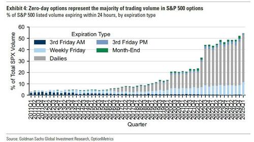
Next expiry options — better known as 0DTEs — aren’t just for a handful of meme stock speculators anymore. They make up more than 50% of all SPX options volume, up from just 17% in 2020. That means intraday flows are influencing price action more than ever.
And here’s the kicker: 88.5% of all options trading is happening on-exchange and retail.
Translation? The pros are watching your moves. And if you don’t understand how your trades affect hedging flows, you’re the one getting played.
Trading Edge: Monitor 0DTE gamma positioning before the open. SpotGamma’s HIRO and TRACE tools show where dealers are getting pinned, or forced to chase.
* * *
2. Fundamentals Light the Fuse, Options Flows Decide the Blast Radius
Netflix’s post-earnings jump in January? The market expected a 7% move. It ripped 14% higher, directly toward a $1,000 call wall SpotGamma flagged the day before.
“There are large positions up at $1,000… there is enough gamma that NFLX could move more than just 7%” – SpotGamma Founder Brent Kochuba, January 21, 2025
Why was this?
By reading the options market, it was clear that options flows could exacerbate any price movement — with no overhead resistance until the $1,000 strike for NFLX.
Trading Edge: Use SpotGamma’s Equity Hub to track support/resistance levels defined by options open interest — not lagging technicals. If there’s a wall of gamma, you’d better believe price will bounce or stall there.
* * *
3. Market Makers Are the Real Movers
Every option trade needs a hedge, and that hedge moves markets. If 100,000 calls are…

Alliance for Uniting Romanians leader George Simion received 35 percent.

“The US role in this is larger than anyone has officially confirmed up until this point.”

Warren Buffett is well-known for his investment acumen, and he often makes public statements in favor of capitalism. But his loyalty to the fiat monetary system undermines everything else that he claims to represent.