

- Click here to visit Dr. John Campbell’s Youtube Channel
- LinkedIn profile
- Twitter Or X Account
- Facebook page
How The Ukraine Minerals Deal Supports US Strategy And Ukrainian Security
Authored by Milo Austin and WIlson Beaver via The Epoch Times (emphasis ours),
China currently has a significant advantage over the United States in terms of critical minerals.
These minerals are “critical” for the production of green energy technology, the semiconductors used in consumer electronics, and military hardware—including missiles, aircraft, and ammunition.
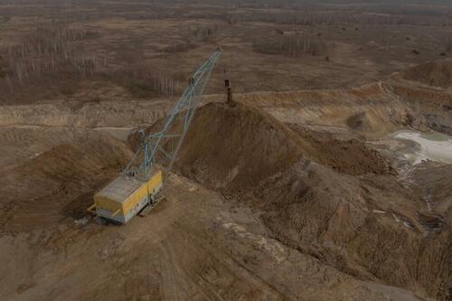
An aerial view shows a dragline excavator operating in an open-pit titanium mine in the Zhytomyr region, Ukraine, on Feb. 28, 2025. Roman Pilipey/AFP via Getty Images
The PRC controls over 90 percent of the world’s production of gallium, over 80 percent of the production of magnesium, tungsten, and bismuth, and over 70 percent of the production of graphite. China also controls between 40 and 50 percent of the world’s supply of refined rare earth elements. Domestic production of critical minerals is comparatively weak, and the construction of new mines was repeatedly blocked by the Department of the Interior and the Environmental Protection Agency under President Joe Biden.
If we are to successfully counter Chinese influence in the Indo-Pacific, it is imperative that we secure new sources of critical minerals and grow our ability to refine them.
In light of these challenges, President Donald Trump has indicated his intent to promote the production of critical minerals both at home and abroad.
The Ukraine minerals deal, which will set up a “reconstruction investment fund” with the revenues from Ukrainian government-owned natural resources, is a significant step in the right direction.
The deal accomplishes several important goals.
First, it provides capital for the reconstruction of Ukraine’s devastated infrastructure and is designed to attract additional private sector investment, giving Ukraine a path toward financial recovery from the war.
Second, it compensates the U.S. for billions of dollars’ worth of military and financial assistance provided to Ukraine since the beginning of the invasion.
Third, it will create Western buy-in for the region’s stability that could deter future Russian aggression in lieu of a formal security guarantee.
Finally, and most importantly, it will give the U.S. a new source of the critical minerals and rare earth elements needed to expand semiconductor production and rebuild and modernize the military.
Ukraine is of particular importance because it is one of the most resource-rich countries in Europe. The Ukrainian government estimates that the country contains 5 percent of the world’s critical minerals, with large deposits of graphite, titanium, lithium, beryllium, uranium, and rare earth elements. Moreover, because of a lack of capital and sophisticated mining technology, only 15 percent of deposits were being exploited when the invasion began in 2022.
According to the director of a Ukrainian graphite factory, 70 percent of Ukraine’s critical minerals have not been mined. Up to $350 billion worth of these minerals are found in areas under Russian occupation, but the remainder are still accessible to foreign and domestic mining interests.
The deal is good for both Ukraine and for the United States, and ought to move forward.
Reprinted by permission from The Daily Signal, a publication of The Heritage Foundation.
Views expressed in this article are opinions of the author and do not necessarily reflect the views of The Epoch Times…
Ukrainian President Volodymyr Zelensky urged US counterpart Donald Trump on Sunday to visit his country to better understand the devastation wrought by Russia’s invasion. “Please, before any kind of decisions, any kind of forms of negotiations, come to see people, civilians, warriors, hospitals, churches, children destroyed or dead,” he said according to a transcript of […]
The post Zelensky urges Trump to visit Ukraine to see war devastation: CBS appeared first on Insider Paper.

“I cannot understand why they think they can attempt to intimidate parents in this way.”
A federal judge on Friday ordered President Donald Trump’s U.S. Department of Agriculture (USDA) to unfreeze federal funding to Maine, as the administration continues to battle the Democrat-run state over transgender athletes.
The post Federal Judge Orders USDA to Unfreeze Funding to Maine as Trans Athletes Dispute Continues appeared first on Breitbart.

Pennsylvania Gov. Josh Shapiro (D) revealed on Sunday that an arsonist had “set fire” to the Governor’s Residence in Harrisburg, adding that his family had been evacuated from the residence.
The post Pennsylvania Gov. Josh Shapiro Reveals Arsonist ‘Set Fire’ to Governor’s Mansion appeared first on Breitbart.

Man ‘Erroneously Deported’ Is Alive In El Salvador Prison: Official
Kilmar Abrego Garcia, the man the US government has acknowledged erroneously deporting, is alive in a prison in El Salvador, according to a new State Department court filing.
Kilmar Abrego Garcia in a file photo. Abrego Garcia Family/Handout via Reuters
“It is my understanding based on official reporting from our Embassy in San Salvador that Abrego Garcia is currently being held in the Terrorism Confinement Center in El Salvador,” said State Dept. official Michael Kozak in a sworn declaration to a federal judge in Washington. “He is alive and secure in that facility. He is detained pursuant to the sovereign, domestic authority of El Salvador.”
The filing is the first since a federal judge overseeing the Abrego Garcia case ordered the Trump administration to provide daily updates on how they’re effectuating his return to the United States.
Abrego Garcia, an El Salvadorian national, was illegally residing in the United States when he was arrested and deported to El Salvador in March due to what US authorities claim was a “prominent role” in the MS-13 gang.
While an immigration judge had previously ruled that there was strong evidence the man was a member of MS-13, a different judge issued a withholding of removal – preventing his deportation to his home country over concerns that he would not be safe there.
The US government subsequently admitted that the deportation was due to an administrative error.
On April 10, the US Supreme Court ruled that the government must “facilitate” the release of Garcia from El Salvadorian custody, and make sure his case “is handled as it would have been had he not been improperly sent to El Salvador.”
Meanwhile, President Donald Trump said on April 11 that he will honor the Supreme Court order.
As the Epoch Times notes further, when asked about the court ruling, Trump told reporters aboard Air Force One: “If the Supreme Court said bring somebody back, I would do that.”
“I respect the Supreme Court,” the president added.
The federal government removed illegal immigrant Kilmar Armando Abrego Garcia from the United States to El Salvador on March 15. He is now detained at the Center for Terrorism Confinement, a maximum security prison in Tecoluca, El Salvador, the Supreme Court noted in its April 10 opinion. The opinion was unsigned. No justices dissented.
The Trump administration agreed a month ago to pay El Salvador $6 million to detain about 300 alleged members of the Venezuelan Tren de Aragua gang and two alleged members of the MS-13 gang in its prisons for one year. The United States has designated both criminal gangs as foreign terrorist organizations.
The government has acknowledged that Abrego Garcia was subject to a withholding order and that his deportation took place because of an “administrative error.” The government has also acknowledged that his removal to El Salvador was “illegal,” the court said.
After an immigration judge signs a deportation order, he then has discretion to issue an order withholding removal, which prevents the government from moving forward with the deportation. The…

Originally posted at MenNeedToBeHeard YouTube Channel
About
Raising Awareness on the many issues affecting men & boys in today’s society
including the societal and media bias against men, the issues father’s face, dating & relationships, men’s mental health issues, & other issues that affect men such as men’s mental health, homelessness, family court bias, & sadly men un-aliving themselves
Join our Brotherhood of Men Patreon Group: https://www.patreon.com/MenNeedToBeHeard
Follow us:
Instagram: https://www.instagram.com/menneedtobeheard/
Tik Tok: https://www.tiktok.com/@menneedtobeheard3
Twitter: https://twitter.com/MenNeed2BeHeard
Facebook: https://www.facebook.com/MenNeedToBeHeard/
Don’t Forget to Subscribe!
Disclaimer:
Some of these links go to one of my websites and some are affiliate links where I’ll earn a small commission if you make a purchase at no additional cost to you.
The information provided on this website or in any video does not, and is not intended to, constitute legal or theraputic advice.
Links:
Patreon Group
patreon.com/MenNeedToBeHeard
TikTok
tiktok.com/@menneedtobeheardtoo
Instagram
instagram.com/menneedtobeheard
Twitter
twitter.com/MenNeed2BeHeard
Facebook
facebook.com/MenNeedToBeHeard

Prime Minister Keir Starmer called the special sitting, one of only six held on a Saturday since World War II, to prevent the Chinese-owned Jingye Group from closing down the two blast furnaces at the British Steel site.